
File:Motilla del Azuer (29425303165).jpg

Size of this preview: 668 × 600 pixels. Other resolutions: 267 × 240 pixels | 535 × 480 pixels | 856 × 768 pixels | 1,141 × 1,024 pixels | 2,282 × 2,048 pixels | 3,469 × 3,114 pixels.
Original file (3,469 × 3,114 pixels, file size: 2.38 MB, MIME type: image/jpeg)
| This is a file from the Wikimedia Commons. Information from its description page there is shown below. Commons is a freely licensed media file repository. You can help. |
.jpg)
Summary
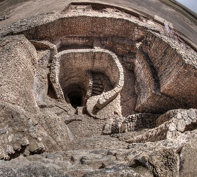
| Description | Las "motillas" son yacimientos fortificados de la Edad del Bronce datados en el periodo entre los años 2200 y 1500 a.C. Son específicos de zona de La Mancha, donde se ha localizado una veintena. La Motilla del Azuer es la única visitable en este omento. Está en Daimiel y es una construcción compleja con varias murallas, pasillo tortuosos y un gran patio donde se ubica un pozo, descubierto y excavado recientemente.El poblado es exterior a las murallas y dentro de la motilla aparecen estancias que sirvieron de almacenes de grano. Posiblemente se trataba de una estructura de refugio y defensa, no preparada para ser usada como vivienda durante largos periodos. La foto muestra el pozo desde la torre central. |
| Date | |
| Source | Motilla del Azuer |
| Author | Ángel M. Felicísimo from Mérida, España |
| Camera location | | View this and other nearby images on: OpenStreetMap |
|---|
.jpg¶ms=039.043309_N_-003.497386_E_globe:Earth_type:camera_source:Flickr_&language=en)
Licensing
This file is licensed under the Creative Commons Attribution 2.0 Generic license.
- You are free:
- to share – to copy, distribute and transmit the work
- to remix – to adapt the work
- Under the following conditions:
- attribution – You must give appropriate credit, provide a link to the license, and indicate if changes were made. You may do so in any reasonable manner, but not in any way that suggests the licensor endorses you or your use.
| This image was originally posted to Flickr by Á. M. Felicísimo at https://flickr.com/photos/8146925@N08/29425303165 (archive). It was reviewed on 21 August 2018 by FlickreviewR 2 and was confirmed to be licensed under the terms of the cc-by-2.0. |
File history
Click on a date/time to view the file as it appeared at that time.
| Date/Time | Thumbnail | Dimensions | User | Comment | |
|---|---|---|---|---|---|
| current | 20:29, 21 August 2018 | | 3,469 × 3,114 (2.38 MB) | Tm | Transferred from Flickr via #flickr2commons |
File usage
The following pages on the English Wikipedia use this file (pages on other projects are not listed):
Global file usage
The following other wikis use this file:
- Usage on de.wikipedia.org
- Usage on es.wikipedia.org
- Usage on fr.wikipedia.org
- Usage on hy.wikipedia.org
- Usage on it.wikipedia.org
- Usage on www.wikidata.org
.jpg)