
File:NABATAEAN TRADE ROUTES.png
Original file (886 × 727 pixels, file size: 334 KB, MIME type: image/png)
| This is a file from the Wikimedia Commons. Information from its description page there is shown below. Commons is a freely licensed media file repository. You can help. |
Summary
| Description |
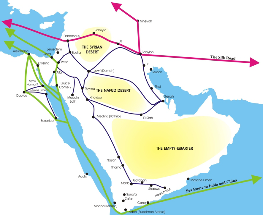
British English: Many historians have puzzled over the early trade routes of the Nabataeans. Since there were no distinctive Nabataean cities at this time, most discussion on this topic disintegrates into vague generalities. However, in my book, The Nabataeans, Builders of Petra, I examine the Nabataean people in the light of their social standing, and present a case for seeing the Nabataeans as a people who were traditionally scorned and scoffed at. I point out that because of their low social standing, at least in their early history; they developed their own trade routes and watering systems in the Arabian desert. In the book I also compare them to modern day gypsies and Turkomen who quietly conduct trade in the Middle East to this very day, following the patterns set down by very ancient traders and merchants.
This paper is not focused on any particular theory, but rather presents a number of topics that should be considered when considering Nabataean trade. It starts by outlining the chronological development of Nabataean trade in very broad lines. It then moves on to examine various aspects of Nabataean trade. Chronological Over View of Nabataean Trade Early History 1900 BC - 600 BC In my paper "A Short History of the Tribes of Northern Arabia" I point out that from 1900 BC to 600 BC, the Nabataeans were known as an Arab tribe that engaged in trading. While their brother tribe, the Qedarites, were known for their military prowess, the Nabataeans seem to be content with running camel caravans in the interior of what is Saudi Arabia today. Acting as merchants they linked Arabia, the Hagarites, Mesopotamia and Edom. I believe that this trade was shared with the other sons of Ishmael, who also were tribes conducting trade in Arabia at the same time. During this period, the Nabataeans established small colonies in tent communities on the outskirts of many of the major centers of Arabia, Mesopotamia, and the Levant. Some examples of these communities are: Meda'in Saleh near Dedan the Lihyanite capital, Jenysos south of Gaza, Selah near Busheira, the Edomite Capital. During this period, the major Arabian trade routes included: 1. The Central Arabian Desert Route. Goods traveled from Southern Arabia (Yemen) through the Arabian Peninsula to the land of Edom. From Edom goods moved north to Damascus or west to Egypt. 2. The Eastern Arabian Desert Route. Goods traveled from Southern Arabia (Oman) along the eastern coast by boat by Gerrhean merchants to ports in Mesopotamia. From here goods made their way to Babylon where they joined the Silk Road. Goods then traveled through Damascus to the Phoenicians on the Mediterranean Sea. 600 - 250 BC In the period from 600 BC - 250 BC the Nabataeans first began using boats to pirate on the Red Sea and later on the Mediterranean Sea, from the port of Gaza. This story is recorded for us by Diodorus. There is no evidence that they engaged in maritime trade at this time. Diodorus tells us: "After one has sailed past this country, the Laeanites Gulf comes next, about which are many inhabited villages of Arabs who are known as Nabataeans. This tribe occupies a large part of the coast and not a little of the country which stretches inland, and it has a people beyond telling and flocks and herds in multitude beyond belief. Now in ancient times these men observed justice and were content with the food which they received from their flocks, but later, after the kings of Alexandria had made the ways of the sea navigable for their merchants, these Arabs not only attacked the shipwrecked, but fitting out pirate ships and preyed upon the voyagers, imitating in their practice the savage and lawless ways of the Tauri of the Pontusl. Some time afterwards, however, they were caught on the high seas by some quadriremes and punished as they deserved." (III.43.4) According to the Zenon Papyri, the Nabataeans were competing with the Mineans and the Gerrheans for the incense trade. These traders were using the overland routes. 250 - 100 BC Three kingdoms existed in southern Arabia. The two inside kingdoms faced the desert, and handled all of the contact with Arab traders. They did not allow frankincense to be moved by boat as the frankincense field lay between them and the coast. However, some of the states along the shore started using boats anyway. They would carry the frankincense to an island and Nabataean boats would pick it up and bringing it north to their new port at Leuce Come. From Leuce Come goods would travel up the coast to Aila, and then inland through the newly developing Nabataean Empire to Egypt, Damascus, Mesopotamia, Greece, and Rome. During this period, the Ptolemies in Egypt built a series of ports down the African coast to facilitate the importing of elephants from around the African Horn. Nabataean boats carrying cargos from South Yemen to Leuce Come also added the Egyptian port of Berenike to their route. From Berenike goods were sent across the land bridge to Alexandria. During this time Indian and Chinese goods also started arriving at Arabia ports. They were also transported across land to the Mediterranean port of Alexandria where ships carried them to the various civilizations around the Mediterranean Sea. This Foreign trade became so intense that China and India sent trade ambassadors to the Middle East during this time. For example, trade embassies which were exchanged between Philadelphos of Alexandria and the great Asoka of India. This clearly testifies to tentative direct relations between the Ptolemies of Egypt and India. (Kortenbeutel, op. cit., p29). Along with this, an envoy of Chinese Emperor Wu-ti, of the Chinese Han dynasty made a visit to the Middle East in 138 - 122 BC. This envoy, Chang Ch'ien mentions a gift from the Arab king of jugglers from Rekeem, (the Nabataean name for Petra). During this time the Himyarite kingdom in south Arabia began to grow significantly, as the Nabataeans increased their maritime trade with them. It appears that eventually the Nabataeans allied themselves with the Himyarites against the other kingdoms of South Arabia.. 100 BC - 85 BC The Nabataean port city of Gaza seemed to be loosing its importance. Most Nabataean Arabian and Asian trade seemed to be passing through Alexandria. Gaza was eventually lost to Jewish control. The Nabataeans continued their expansion northwards at the expense of Gaza. They gained control of the ancient city of Damascus in 85 BC. This allowed them to completely dominate the land and sea routes from the east. The Nabataeans now controlled the Silk Road, the Frankincense Road, the King's Highway, and the maritime trade routes with India and Sri Lanka. The Nabataeans suddenly emerged as a world class economic power. At this point they then began to work hard on projecting a global image or wealth, opulence and honor. One of these projects was the construction of a world class capital city, Petra. 20-30 BC During the Roman campaign to south Yemen to discover the source of frankincense, the Nabataeans not only managed to destroy the Roman army through deception, they effectively used the Romans against the Hadramites and the Mineans. While they did not defeat these kingdoms, they severely weakened them so that the following year the Himyarites began to conquer them. Eventually the Himyarites took control of frankincense production, and all frankincense trade was hereafter conducted by ships to Nabataea, causing the Gerrhean civilization to crumble. 106 AD At this point in history the Roman Empire acquired (not conquered) the Nabataean Empire. It appears that the Nabataeans sold their Empire to the Romans in order to gain Roman citizenship for their nobility, and also to gain monopoly over the East Asia trade. |
| Date | |
| Source | http://nabataea.net/trader.html |
| Author | Gibson's book: Qur'anic Geography |
Licensing
- You are free:
- to share – to copy, distribute and transmit the work
- to remix – to adapt the work
- Under the following conditions:
- attribution – You must give appropriate credit, provide a link to the license, and indicate if changes were made. You may do so in any reasonable manner, but not in any way that suggests the licensor endorses you or your use.
- share alike – If you remix, transform, or build upon the material, you must distribute your contributions under the same or compatible license as the original.
File history
Click on a date/time to view the file as it appeared at that time.
| Date/Time | Thumbnail | Dimensions | User | Comment | |
|---|---|---|---|---|---|
| current | 10:35, 13 January 2017 | | 886 × 727 (334 KB) | Hen6666 | User created page with UploadWizard |
File usage
Global file usage
The following other wikis use this file:
- Usage on cs.wikipedia.org
- Usage on es.wikipedia.org
- Usage on fr.wikipedia.org
- Usage on he.wikipedia.org
- Usage on it.wikipedia.org
- Usage on ja.wikipedia.org
- Usage on ka.wikipedia.org
- Usage on sl.wikipedia.org