
File:New Mexico Presidential Election Results 2020.svg

Size of this PNG preview of this SVG file: 600 × 600 pixels. Other resolutions: 240 × 240 pixels | 480 × 480 pixels | 768 × 768 pixels | 1,024 × 1,024 pixels | 2,048 × 2,048 pixels | 810 × 810 pixels.
Original file (SVG file, nominally 810 × 810 pixels, file size: 17 KB)
| This is a file from the Wikimedia Commons. Information from its description page there is shown below. Commons is a freely licensed media file repository. You can help. |
Summary
| Description |
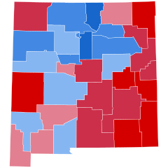
English: State election results in New Mexico, by county (presidential election 2020)
Source: https://www.nytimes.com/interactive/2020/11/03/us/elections/results-new-mexico.html |
| Date | |
| Source | Own work |
| Author | KyleReese64 |
Licensing
I, the copyright holder of this work, hereby publish it under the following license:
This file is licensed under the Creative Commons Attribution-Share Alike 4.0 International license.
- You are free:
- to share – to copy, distribute and transmit the work
- to remix – to adapt the work
- Under the following conditions:
- attribution – You must give appropriate credit, provide a link to the license, and indicate if changes were made. You may do so in any reasonable manner, but not in any way that suggests the licensor endorses you or your use.
- share alike – If you remix, transform, or build upon the material, you must distribute your contributions under the same or compatible license as the original.
File history
Click on a date/time to view the file as it appeared at that time.
| Date/Time | Thumbnail | Dimensions | User | Comment | |
|---|---|---|---|---|---|
| current | 22:47, 10 June 2023 | | 810 × 810 (17 KB) | Putitonamap98 | shapes |
| 02:29, 15 January 2023 |  | 744 × 744 (103 KB) | Putitonamap98 | fix | |
| 05:06, 14 January 2023 |  | 744 × 744 (103 KB) | Gordfather69 | Reverted to version as of 16:15, 25 December 2022 (UTC) | |
| 16:24, 25 December 2022 |  | 744 × 744 (107 KB) | Putitonamap98 | fix | |
| 16:15, 25 December 2022 |  | 744 × 744 (103 KB) | Putitonamap98 | shapes | |
| 21:48, 5 September 2022 |  | 744 × 744 (107 KB) | Elli | Reverted to version as of 06:19, 13 May 2022 (UTC) undo reverts to worse maps | |
| 03:38, 28 August 2022 |  | 208 × 215 (23 KB) | TylerKutschbach | Reverted to version as of 01:50, 8 November 2021 (UTC) Back to standard map, please keep it like this to have consistency with all previous maps. | |
| 06:19, 13 May 2022 |  | 744 × 744 (107 KB) | Kingofthedead | Reverted to version as of 04:19, 5 November 2021 (UTC) | |
| 01:50, 8 November 2021 |  | 208 × 215 (23 KB) | Putitonamap98 | Reverted to version as of 06:49, 8 November 2020 (UTC) back to standard style please reach a consensus first before making such a change | |
| 04:19, 5 November 2021 |  | 744 × 744 (107 KB) | Fluffy89502 | county lines |
File usage
The following pages on the English Wikipedia use this file (pages on other projects are not listed):
Global file usage
The following other wikis use this file:
- Usage on fr.wikipedia.org
- Usage on simple.wikipedia.org