
File:Orontid Armenia -250-en.svg

Size of this PNG preview of this SVG file: 800 × 470 pixels. Other resolutions: 320 × 188 pixels | 640 × 376 pixels | 1,024 × 601 pixels | 1,280 × 751 pixels | 2,560 × 1,503 pixels | 2,717 × 1,595 pixels.
Original file (SVG file, nominally 2,717 × 1,595 pixels, file size: 766 KB)
| This is a file from the Wikimedia Commons. Information from its description page there is shown below. Commons is a freely licensed media file repository. You can help. |
Summary
| Description |
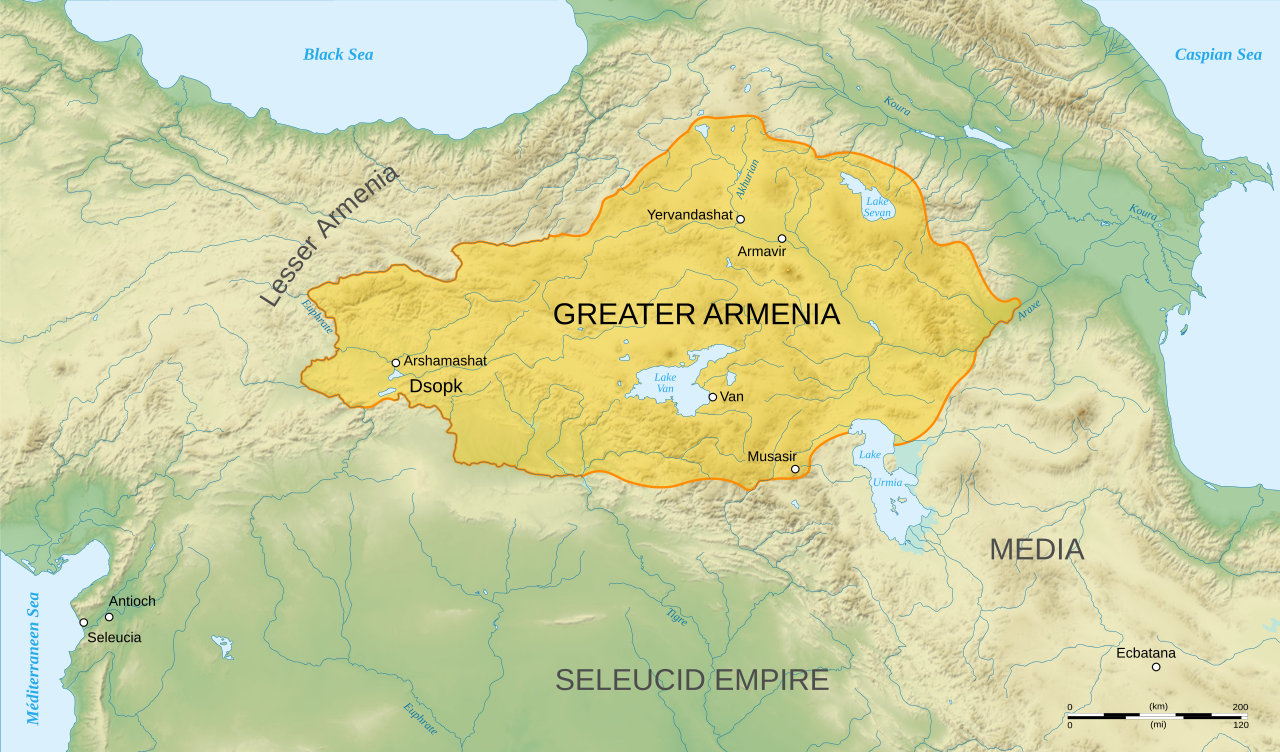
English: Map of Orontid Armenia, around the year 250 BCE.
Français : Carte en anglais de l'Arménie sous la dynastie orontide, vers l'an -250. |
||
| Date | |||
| Source |
Own work.
Sources :
Software used :
Autres données :
|
||
| Author | Sémhur | ||
| Other versions |
[]
| ||
| Attribution (required by the license) | © Sémhur / Wikimedia Commons / | ||
| SVG | W3C-validity not checked.
|
||
| Atelier graphique |


| Camera location | | View this and other nearby images on: OpenStreetMap |
|---|
Licensing
I, the copyright holder of this work, hereby publish it under the following licenses:
| Copyleft: This work of art is free; you can redistribute it and/or modify it according to terms of the Free Art License. You will find a specimen of this license on the Copyleft Attitude site as well as on other sites. |
This file is licensed under the Creative Commons Attribution-Share Alike 4.0 International, 3.0 Unported, 2.5 Generic, 2.0 Generic and 1.0 Generic license.
- You are free:
- to share – to copy, distribute and transmit the work
- to remix – to adapt the work
- Under the following conditions:
- attribution – You must give appropriate credit, provide a link to the license, and indicate if changes were made. You may do so in any reasonable manner, but not in any way that suggests the licensor endorses you or your use.
- share alike – If you remix, transform, or build upon the material, you must distribute your contributions under the same or compatible license as the original.
You may select the license of your choice.
File history
Click on a date/time to view the file as it appeared at that time.
| Date/Time | Thumbnail | Dimensions | User | Comment | |
|---|---|---|---|---|---|
| current | Orontid Armenia, around the year -250 AD.}} {{fr| Carte en anglais de l'Arménie sous la dynastie orontide , vers l'an -250.}} |Source=Own work. { |
File usage
The following pages on the English Wikipedia use this file (pages on other projects are not listed):
Global file usage
The following other wikis use this file:
- Usage on ar.wikipedia.org
- Usage on avk.wikipedia.org
- Usage on azb.wikipedia.org
- Usage on fa.wikipedia.org
- Usage on hy.wikipedia.org
- Տիգրան Մեծ
- Հայեր
- Տրդատ Գ
- Արտաշեսյաններ
- Երվանդունիներ
- Արշակունիներ
- Վաղարշակ Ա
- Ռուբեն Ա
- Արտավազդ Ա
- Արտավազդ Գ
- Արտավազդ Դ
- Արտավազդ Ե
- Արտավազդ Բ
- Արտաշես Ա Բարեպաշտ
- Արտաշես Դ
- Վռամշապուհ
- Արտաշես Բ
- Արշակ Ա
- Արշակ Գ
- Արշակ Բ
- Պապ թագավոր
- Աշոտ Ա Մեծ
- Աշոտ Գ Ողորմած
- Աշոտ Դ Քաջ
- Գագիկ Բ
- Հովհաննես-Սմբատ
- Հեթում Ա
- Ֆիլիպ (Կիլիկիայի թագավոր)
- Հեթում Բ
- Հեթումյաններ
- Օշին Ա
- Տրդատ Բ
- Տրդատ Ա
- Խոսրով Ա
- Վաղարշ Ա
- Սոհեմոս
- Վաղարշ Բ
- Լևոն Ե
- Լևոն Դ
View more global usage of this file.