
File:Palestine governorates.png
Size of this preview: 515 × 599 pixels. Other resolutions: 206 × 240 pixels | 413 × 480 pixels | 755 × 878 pixels.
Original file (755 × 878 pixels, file size: 23 KB, MIME type: image/png)
| This is a file from the Wikimedia Commons. Information from its description page there is shown below. Commons is a freely licensed media file repository. You can help. |
Summary
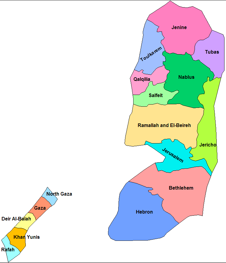
| Description | Map of the governorates of Palestine. Created by Rarelibra 21:51, 17 April 2007 (UTC) for public domain use, using MapInfo Professinal v8.5 and various mapping resources. |
| Date | 17 April 2007 (original upload date) |
| Source | No machine-readable source provided. Own work assumed (based on copyright claims). |
| Author | No machine-readable author provided. Rarelibra assumed (based on copyright claims). |
Licensing
| I, the copyright holder of this work, release this work into the public domain. This applies worldwide. In some countries this may not be legally possible; if so: I grant anyone the right to use this work for any purpose, without any conditions, unless such conditions are required by law. |
File history
Click on a date/time to view the file as it appeared at that time.
| Date/Time | Thumbnail | Dimensions | User | Comment | |
|---|---|---|---|---|---|
| current | 00:37, 3 July 2007 | | 755 × 878 (23 KB) | Timeshifter | Cropped image of original creator/uploader to eliminate white space to left and right. Original creator released image under <nowiki>{{PD-self}}</nowiki> |
| 21:51, 17 April 2007 |  | 1,281 × 878 (26 KB) | Rarelibra | Map of the governorates of Palestine (Palestinian Occupied Territory). Created by ~~~~ for public domain use, using MapInfo Professinal v8.5 and various mapping resources. |
File usage
The following pages on the English Wikipedia use this file (pages on other projects are not listed):
- Bethlehem Governorate
- Deir al-Balah Governorate
- Gaza Governorate
- Governorates of Palestine
- Hebron Governorate
- Jenin Governorate
- Jericho Governorate
- Jerusalem Governorate
- Khan Yunis Governorate
- Nablus Governorate
- North Gaza Governorate
- Qalqilya Governorate
- Rafah Governorate
- Ramallah and al-Bireh Governorate
- Salfit Governorate
- Tubas Governorate
- Tulkarm Governorate
- User:Falcaorib
- User:Kharbaan Ghaltaan/sandbox
- Template:Governorates of the State of Palestine
- Template talk:Governorates of the State of Palestine
Global file usage
The following other wikis use this file:
- Usage on arz.wikipedia.org
- Usage on ast.wikipedia.org
- Usage on ca.wikipedia.org
- Franja de Gaza
- Cisjordània
- Estat de Palestina
- Governació de Gaza Nord
- Plantilla:Governacions Palestina
- Governació de Gaza
- Governació de Deir al-Balah
- Governació de Khan Yunis
- Governació de Rafah
- Governació de Jerusalem
- Governació de Betlem
- Governació d'Hebron
- Governació de Ramal·lah i al-Bireh
- Governació de Jericó
- Governació de Salfit
- Governació de Nablus
- Governació de Qalqilya
- Governació de Tubas
- Governació de Tulkarem
- Governació de Jenin
- Governacions de Palestina
- Usage on es.wikipedia.org
- Usage on eu.wikipedia.org
- Gazako Gobernazioa
- Kategoria:Palestinako gobernazioak
- Hebrongo Gobernazioa
- Jerusalemgo Gobernazioa
- Rafahko Gobernazioa
- Palestina Estatuko lurralde-antolaketa
- Tubasko Gobernazioa
- Salfitko Gobernazioa
- Khan Yunisko Gobernazioa
- Jeningo Gobernazioa
- Tulkaremgo Gobernazioa
- Nablusko Gobernazioa
- Jerikoko Gobernazioa
- Ramalla eta al-Birehko Gobernazioa
- Qalqiliyako Gobernazioa
- Betleemgo Gobernazioa
- Ipar Gazako Gobernazioa
- Deir al-Balahko Gobernazioa
- Txantiloi:Palestinako gobernazioak
- Usage on fa.wikipedia.org
View more global usage of this file.