
File:Paris Metro Ligne 1.svg

Size of this PNG preview of this SVG file: 512 × 197 pixels. Other resolutions: 320 × 123 pixels | 640 × 246 pixels | 1,024 × 394 pixels | 1,280 × 493 pixels | 2,560 × 985 pixels.
Original file (SVG file, nominally 512 × 197 pixels, file size: 13 KB)
| This is a file from the Wikimedia Commons. Information from its description page there is shown below. Commons is a freely licensed media file repository. You can help. |
Summary
| Description |
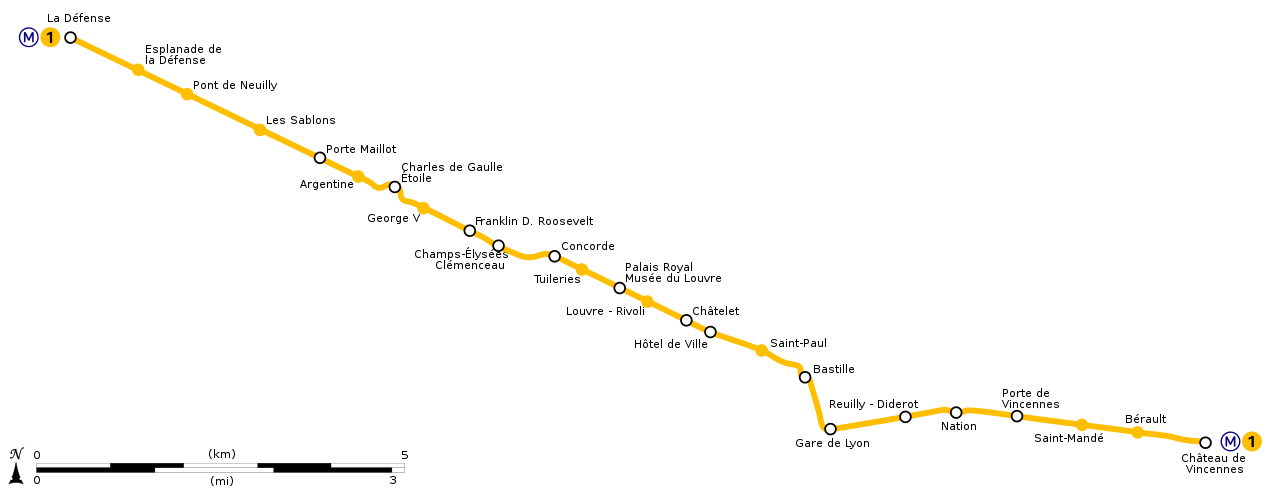
English: Geographically accurate path of Paris Métro Line 1. Français : Plan géographique de la ligne 1 du métro de Paris. |
||
| Date | (UTC) | ||
| Source | File:Ligne 1.gif by Metropolitan under licence Public Domain | ||
| Author | Sémhur (talk) | ||
| Other versions | |||
| SVG |
|
||
| Graphic Lab |

| Object location | | View this and other nearby images on: OpenStreetMap |
|---|
Licensing
I, the copyright holder of this work, hereby publish it under the following license:
| This file is made available under the Creative Commons CC0 1.0 Universal Public Domain Dedication. | |
| The person who associated a work with this deed has dedicated the work to the public domain by waiving all of their rights to the work worldwide under copyright law, including all related and neighboring rights, to the extent allowed by law. You can copy, modify, distribute and perform the work, even for commercial purposes, all without asking permission.
|
File history
Click on a date/time to view the file as it appeared at that time.
| Date/Time | Thumbnail | Dimensions | User | Comment | |
|---|---|---|---|---|---|
| current | 17:53, 17 July 2020 | 512 × 197 (13 KB) | Teo.raff | Metro and line icons and colours update | |
| 23:21, 12 October 2018 | 2,166 × 834 (40 KB) | AlexBurn44 | corres | ||
| 12:14, 13 March 2015 | 2,166 × 834 (41 KB) | Sémhur | REmove black line | ||
| 16:47, 28 December 2014 | 2,166 × 834 (37 KB) | Sémhur | == {{int:filedesc}} == {{Information |Description={{Multilingual description |en= Geographically accurate path of en:Paris Métro Line 1. |fr= Plan géographique de la fr:ligne 1 du métro de Paris. }} |Source=File:Ligne 1.gif by [[:en... |
File usage
The following pages on the English Wikipedia use this file (pages on other projects are not listed):
Global file usage
The following other wikis use this file:
- Usage on bs.wikipedia.org
- Usage on cs.wikipedia.org
- Usage on dsb.wikipedia.org
- Usage on eo.wikipedia.org
- Usage on es.wikipedia.org
- Usage on fr.wikipedia.org
- Usage on it.wikipedia.org
- Usage on ja.wikipedia.org
- Usage on ko.wikipedia.org
- Usage on lb.wikipedia.org
- Usage on nl.wikipedia.org
- Usage on no.wikipedia.org
- Usage on oc.wikipedia.org
- Usage on pl.wikipedia.org
- Usage on ru.wikipedia.org
- Usage on sk.wikipedia.org
- Usage on tr.wikipedia.org
- Usage on uk.wikipedia.org
- Usage on zh-min-nan.wikipedia.org
- Usage on zh.wikipedia.org