
File:Picoduartemap.jpg

Size of this preview: 643 × 599 pixels. Other resolutions: 258 × 240 pixels | 515 × 480 pixels | 824 × 768 pixels | 1,099 × 1,024 pixels | 2,197 × 2,048 pixels | 3,280 × 3,057 pixels.
Original file (3,280 × 3,057 pixels, file size: 1.5 MB, MIME type: image/jpeg)
| This is a file from the Wikimedia Commons. Information from its description page there is shown below. Commons is a freely licensed media file repository. You can help. |
Summary

|
This file was moved to Wikimedia Commons from en.wikipedia using a bot script. All source information is still present. It requires review. Additionally, there may be errors in any or all of the information fields; information on this file should not be considered reliable and the file should not be used until it has been reviewed and any needed corrections have been made. Once the review has been completed, this template should be removed. For details about this file, see below. Check now!
|
| Description |
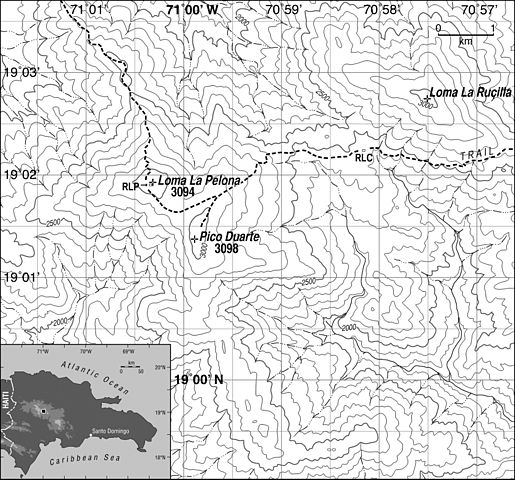
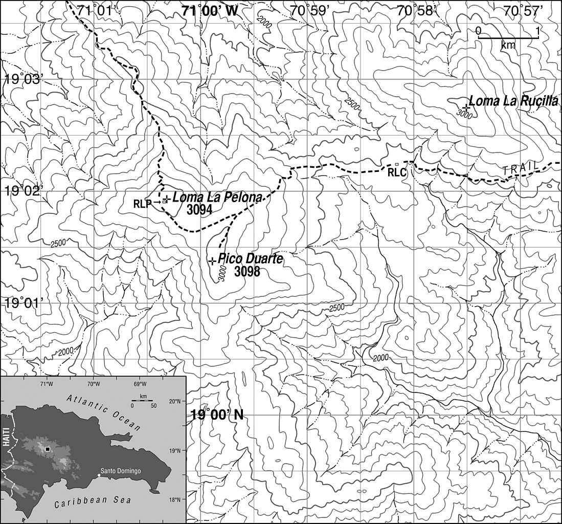
English: Map general area surrounding Pico Duarte. Contour interval is 100 m. RLP: Refugio La Pelona. RLC: Refugio La Compartición. Inset shows Dominican Republic with location of main map highlighted. Datum is WGS 84; projection is Universal Transverse Mercator (19N). Trails and shelters were mapped using GPS and aerial photography; topography and streams were adjusted from the Lamedero (NW, 1969), Manabao (NE, 1969), Juan de Herrera (SW, 1969) and Gajo de Monte (SE, 1962) 1:50000 scale topographic quadrangles published by the U.S. Army Map Service and compiled by that group in collaboration with the Instituto Cartográfico Militar, the Instituto Cartográfico Universitario and the Inter-American Geodetic Survey. |
| Date | |
| Source | Kenneth H. Orvis |
| Author | Kenneth H. Orvis |
| Permission (Reusing this file) |
Use is allowed if attribution of author is given |
| Other versions | Other versions are copyrighted by the journals they were published in. Version used is author's own initial sketch. |
Licensing
This file is licensed under the Creative Commons Attribution 1.0 Generic license.
Attribution: Image may be used if name of author is given
- You are free:
- to share – to copy, distribute and transmit the work
- to remix – to adapt the work
- Under the following conditions:
- attribution – You must give appropriate credit, provide a link to the license, and indicate if changes were made. You may do so in any reasonable manner, but not in any way that suggests the licensor endorses you or your use.
Original upload log
Transferred from en.wikipedia to Commons by IngerAlHaosului using CommonsHelper.
The original description page was here. All following user names refer to en.wikipedia.
- 2008-04-04 11:29 Cuyaya 3280×3057× (1571739 bytes) {{Information |Description=Map showing locations discussed in text. Contour interval is 100 m. RLP: Refugio La Pelona. RLC: Refugio La Compartición. Inset shows Dominican Republic with location of main map highlighted. Datum is WGS 84; projection is Univ
File history
Click on a date/time to view the file as it appeared at that time.
| Date/Time | Thumbnail | Dimensions | User | Comment | |
|---|---|---|---|---|---|
| current | 13:28, 31 January 2010 | | 3,280 × 3,057 (1.5 MB) | File Upload Bot (Magnus Manske) | {{BotMoveToCommons|en.wikipedia|year={{subst:CURRENTYEAR}}|month={{subst:CURRENTMONTHNAME}}|day={{subst:CURRENTDAY}}}} {{Information |Description={{en|Map general area surrounding en:Pico Duarte. Contour interval is 100 m. RLP: Refugio La Pelona. R |
File usage
The following pages on the English Wikipedia use this file (pages on other projects are not listed):
Global file usage
The following other wikis use this file:
- Usage on el.wikipedia.org
- Usage on pt.wikipedia.org