| Source |
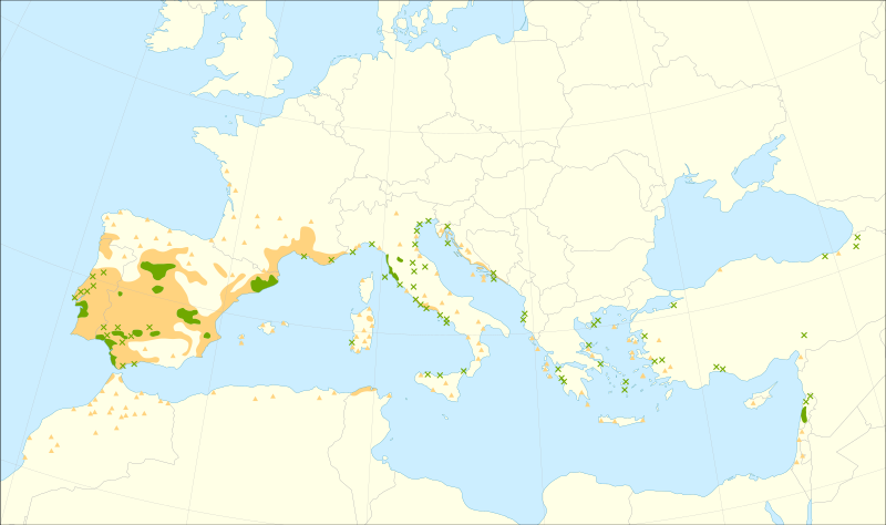
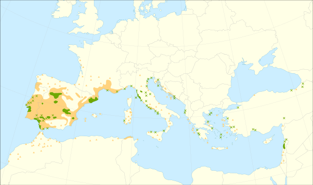
Caudullo, G., Welk, E., San-Miguel-Ayanz, J., 2017. Chorological maps for the main European woody species. Data in Brief 12, 662-666. DOI: 10.1016/j.dib.2017.05.007
Data: https://doi.org/10.6084/m9.figshare.5113951
References:
- Abbas, K., Belhout, T., 2019. Etude de l’activité hypolipidémiante des polyphenols des graines de Pinus pinea L sur des rats hyperlipidémiques induit par le Triton X-100. Master Thesis, Université Akli Mohand Oulhadj Bouira, Alegeria: p. 92.
- Agrimi, M., Ciancio, O., 1993. Le pin pignon (Pinus pinea L.). FAO - Silva Mediterranea, Comité des questions forestières méditerranéennes, Larnaca, Chipre: p. 173.
- Akyol, A., & Örücü, Ö. K., 2019. Investigation and evaluation of stone pine (Pinus pinea L.) current and future potential distribution under climate change in Turkey. Cerne, 25(4), 415-423.
- Alía Miranda, R., García del Barrio, J. M., Iglesias Sauce, S., Mancha Núñez, J. A., de Miguel y del Ángel, J., Nicolás Peragón, J. L., Pérez Martín, F., Sánchez de Ron, D., 2009. Regiones de procedencia de especies forestales en España. Organismo Autónomo Parques Nacionales, Madrid.
- Babac, M. T., Uslu, E., Bakis, Y. TÜBİVES - Turkish Plants Data Service. Accessed in September 2016.
- Bruno, D., Solène, R., 2016. INPN - Données flore des CBN agrégées par la FCBN. Version 1.2. UMS PatriNat (OFB-CNRS-MNHN), Paris. Accessed via GBIF.org. DOI: https://doi.org/10.15468/dl.gkp7wm
- Cambria, S. Flora e vegetazione della Sicilia. Accessed in September 2016.
- Carrasquinho, I., Gonçalves, E., 2013. Genetic variability among Pinus pinea L. provenances for survival and growth traits in Portugal. Tree Genetics & Genomes, 9(3), 855-866.
- CeDoc of Plant Biodiversity (CeDocBIV), Univ. Barcelona, 2009. Sistema de Información de la vegetación Ibérica y Macaronésica. Accessed via GBIF.org. DOI: https://doi.org/10.15468/dl.m8zdd8
- Coşkun, M., Gök, M., Coşkun, S., 2016. An Example of Non-Wood Forest Products in Turkey: Production of Pine Nuts. Journal of Forests, 3(2), 7-15.
- Critchfield, W. B., Little, E. L., 1966. Geographic distribution of the pines of the world. No. 991. U.S. Dept. of Agriculture, Forest Service, Washington, D.C.
- Dobignard, A. Flore du Maroc. Accessed in May 2020.
- EUFORGEN, 2004. Distribution map of Italian stone pine (Pinus pinea). www.euforgen.org
- European Information System on Forest Genetic Resources. EUFGIS database. Accessed in September 2016.
- Farjon, A., 2016. Conifer of the world. Online Database, Department of Plant Sciences, University of Oxford. Accessed in September 2016.
- Flora Ionica Working Group. Flora Ionica – An inventory of ferns and flowering plants of the Ionian Islands (Greece). Accessed in May 2020.
- Font Castell, X., 2018. FloraCAT: Banco de datos de los cormófitos de Cataluña. Version 2.2. Banc de dades de biodiversitat de Catalunya. Accessed via GBIF.org. DOI: https://doi.org/10.15468/dl.biuda7
- Instituto Nacional de Investigación y Tecnología Agraria y Alimentaria INIA. Mapas de distribución de las especies forestales incluidas en el RD289/03. Accessed May 2020.
- Israel Nature and Parks Authority. Israel Nature and Parks Authority. Accessed via GBIF.org. DOI: https://doi.org/10.15468/dl.yaszkm
- Jalas, J., Suominen, J., 1973. Atlas Florae Europaeae: distribution of vascular plants in Europe Vol. 2 Gymnospermae (Pinaceae to Ephedraceae). Committee for Mapping the Flora of Europe and Societas Biologica Fennica Vanamo, Helsinki.
- Kildisheva, O. A., Aghai, M. M., Bouazza, K., Davis, A. S., 2017. Improving restoration success through research-driven initiatives: case studies targeting Pinus pinea reforestation stock development in Lebanon. Plant Ecology, 218(1), 39-53.
- Martínez, F., Montero, G., 2004. The Pinus pinea L. woodlands along the coast of South-western Spain: data for a new geobotanical interpretation. Plant Ecology, 175(1), 1.
- Marín Solís, F. M., 2019. Cartografía de vegetación a escala de detalle 1:10.000 de la masa forestal de Andalucía. Environmental Information Network of Andalusia (REDIAM), Regional Ministry for the Environment, Regional Government of Andalusia. Accessed via GBIF.org. DOI: https://doi.org/10.15468/dl.v7k8vy
- Medina Domingo, L., Aedo Pérez, C., 2019. CSIC-Real Jardín Botánico-Anthos. Sistema de Información de las Plantas de España. Version 1.17. CSIC-Real Jardín Botánico. Accessed via GBIF.org. DOI: https://doi.org/10.15468/dl.9uo7is
- Nikolić, T. (Ed.), 2015. Flora Croatica Database. Faculty of Science, University of Zagreb. Accessed in May 2020.
- Ranz, J., 2017. Banco de Datos de la Biodiversidad de la Comunitat Valenciana. Biodiversity data bank of Generalitat Valenciana. Accessed via GBIF.org. DOI: https://doi.org/10.15468/dl.iru4gq
- Sbay, H., Hajib, S., 2016. Le pin pignon, Une espèce de choix dans le contexte des changements climatiques. Haut Commissariat aux Eaux et Forets et à la Lutte Contre La desertification, Centre de Recherche Forestière, Maroc: p. 77. ISBN 9789954383612
- Sociedade Portuguesa de Botânica. Flora-On: Flora de Portugal interactiva. Accessed in May 2020.
- Sofia, S., Αrgyro, Τ., Vassilios, N., Theodoros, G., 2007. Comparative study of protected areas in Greece: the case-study of three littoral Pinus pinea (stone pine) forests. Fresenius Environmental Bulletin, 16(11a): 1335-1344.
- Strid, A., Tan, K. (eds.), 1997. Flora Hellenica, vol I. Koeltz Scientific Books, Königstein. ISBN: 9783874293914
- Tahar, S., Marc, P., Salah, G., Antonio, B. J., Youssef, A., Miriam, P., 2012. Modeling dominant height growth in planted Pinus pinea stands in Northwest of Tunisia. International Journal of Forestry Research, 2012.
- Tela Botanica. eFlore. Accessed in May 2020.
- Toromani, E., Pasho, E., Alla, A. Q., Mine, V., Çollaku, N., 2015. Radial growth responses of Pinus halepensis Mill. and Pinus pinea L. forests to climate variability in Western Albania. Geochronometria, 42(1): 91-99.
- Varol, O., Tel, A. Z., 2010. Ecological features of the Pinus pinea forests in the north-west region of Turkey (Yalova). Ekoloji, 19(76), 95-101.
|


