
File:Protestant France.svg

Size of this PNG preview of this SVG file: 512 × 410 pixels. Other resolutions: 300 × 240 pixels | 600 × 480 pixels | 959 × 768 pixels | 1,279 × 1,024 pixels | 2,558 × 2,048 pixels.
Original file (SVG file, nominally 512 × 410 pixels, file size: 1.18 MB)
| This is a file from the Wikimedia Commons. Information from its description page there is shown below. Commons is a freely licensed media file repository. You can help. |
Summary
| Description |
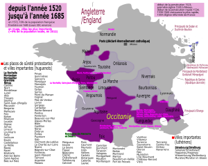
Français : Description de l'étendue approximative des territoires controlés par la noblesse huguenotte (calviniste/réformée) et la noblesse catholique, ainsi que de leurs territoires mutuellement contestés, pendant les Guerres de Religion (1562-1598). La partie à majorité luthérienne (concentrée en Alsace germanophone, en Moselle germanophone et autour de Montbéliard) appartenait au Saint Empire Romain à l'époque.
Légende : Controlé par la noblesse huguenotte
Contesté entre huguenots et catholiques
Controlé par la noblesse catholique
Région à majorité luthérienne |
| Date | |
| Source | Own work |
| Author | Ernio48 |
Licensing
I, the copyright holder of this work, hereby publish it under the following license:
This file is licensed under the Creative Commons Attribution-Share Alike 4.0 International license.
- You are free:
- to share – to copy, distribute and transmit the work
- to remix – to adapt the work
- Under the following conditions:
- attribution – You must give appropriate credit, provide a link to the license, and indicate if changes were made. You may do so in any reasonable manner, but not in any way that suggests the licensor endorses you or your use.
- share alike – If you remix, transform, or build upon the material, you must distribute your contributions under the same or compatible license as the original.
File history
Click on a date/time to view the file as it appeared at that time.
| Date/Time | Thumbnail | Dimensions | User | Comment | |
|---|---|---|---|---|---|
| current | 00:53, 18 March 2024 | | 512 × 410 (1.18 MB) | Ernio48 | Highlighting major cities. |
| 15:52, 24 December 2020 |  | 512 × 410 (1.18 MB) | Ernio48 | Little corrections. | |
| 15:46, 24 December 2020 |  | 512 × 410 (1.07 MB) | Ernio48 | +Foreign actors. | |
| 11:42, 19 December 2020 |  | 512 × 410 (1.07 MB) | Ernio48 | The most important cities that have a significant Reformed population <5%. | |
| 13:55, 14 December 2020 |  | 512 × 410 (970 KB) | Ernio48 | Further corrections to the border. | |
| 22:00, 13 December 2020 |  | 512 × 410 (973 KB) | Ernio48 | Corrections to the border. | |
| 18:52, 13 December 2020 |  | 512 × 410 (979 KB) | Ernio48 | Boundaries as of 1685. | |
| 15:29, 13 December 2020 |  | 512 × 410 (1,020 KB) | Ernio48 | Adding some details (with Paris). | |
| 22:30, 12 December 2020 |  | 512 × 410 (1.01 MB) | Ernio48 | Adding missed places de sûreté protestante | |
| 21:56, 12 December 2020 |  | 512 × 410 (960 KB) | Ernio48 | Error fix 2. Rendering text into path. |
File usage
The following pages on the English Wikipedia use this file (pages on other projects are not listed):
- Ancient Diocese of Alais
- Ancient Diocese of Lavaur
- Camisards
- French Wars of Religion
- Huguenot rebellions
- Huguenots
- Occitania
- Protestantism in France
- Quebec French profanity
- Reformed Church of France
- Religion in France
- Roman Catholic Diocese of Maillezais
- Roman Catholic Diocese of Montauban
- Roman Catholic Diocese of Oloron
- Roman Catholic Diocese of Saint-Pons-de-Thomières
- Siege of La Rochelle
Global file usage
The following other wikis use this file:
- Usage on ar.wikipedia.org
- Usage on azb.wikipedia.org
- Usage on cs.wikipedia.org
- Usage on cy.wikipedia.org
- Usage on de.wikipedia.org
- Usage on es.wikipedia.org
- Usage on fr.wikipedia.org
- Usage on hi.wikipedia.org
- Usage on it.wikipedia.org
- Usage on pl.wikipedia.org
- Usage on pnb.wikipedia.org
- Usage on ro.wikipedia.org
- Usage on ru.wikipedia.org
- Usage on sk.wikipedia.org
- Usage on sl.wikipedia.org
- Usage on sr.wikipedia.org
- Usage on stq.wikipedia.org
- Usage on uk.wikipedia.org
- Usage on ur.wikipedia.org
- Usage on zh.wikipedia.org