
File:Rue des Jardins - Quebec 09.jpg

Size of this preview: 800 × 600 pixels. Other resolutions: 320 × 240 pixels | 640 × 480 pixels | 1,024 × 768 pixels | 1,280 × 960 pixels | 2,560 × 1,920 pixels | 4,608 × 3,456 pixels.
Original file (4,608 × 3,456 pixels, file size: 1.91 MB, MIME type: image/jpeg)
| This is a file from the Wikimedia Commons. Information from its description page there is shown below. Commons is a freely licensed media file repository. You can help. |
Summary
| Description |
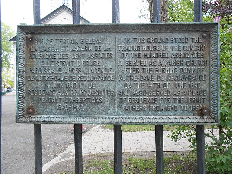
Français : Plaque apposée à la clôture d'un terrain appartenant au diocèse anglican de Québec. On peut y lire : « Sur ce terrain s'élevait la maison et magasin de la Compagnie des Cent Associés. Elle servit d'église paroissiale après l'incendie de Notre-Dame de Recouvrance 14 juin 1640, et de résidence aux RR. PP. Jésuites pendant dix-sept ans 1640-1657. » |
| Date | |
| Source | Own work |
| Author | Jean Gagnon |
| Camera location | | View this and other nearby images on: OpenStreetMap |
|---|
Licensing
I, the copyright holder of this work, hereby publish it under the following license:
This file is licensed under the Creative Commons Attribution-Share Alike 3.0 Unported license.
- You are free:
- to share – to copy, distribute and transmit the work
- to remix – to adapt the work
- Under the following conditions:
- attribution – You must give appropriate credit, provide a link to the license, and indicate if changes were made. You may do so in any reasonable manner, but not in any way that suggests the licensor endorses you or your use.
- share alike – If you remix, transform, or build upon the material, you must distribute your contributions under the same or compatible license as the original.
File history
Click on a date/time to view the file as it appeared at that time.
| Date/Time | Thumbnail | Dimensions | User | Comment | |
|---|---|---|---|---|---|
| current | 23:16, 19 September 2013 | | 4,608 × 3,456 (1.91 MB) | Jeangagnon | {{Information |Description=Plaque apposée à la clôture d'un terrain appartenant au diocèse anglican de Québec. |Source={{own}} |Date=2013-05-26 |Author=Jean Gagnon |Permission= |other_versions= }} {{location dec|46.812677|-71.20745}} [[Category:R... |
File usage
The following pages on the English Wikipedia use this file (pages on other projects are not listed):
Global file usage
The following other wikis use this file:
- Usage on fr.wikipedia.org
- Usage on ru.wikipedia.org