File:Russian Occupation of Mykolaiv Oblast.svg

Page contents not supported in other languages.
This is a file from the Wikimedia Commons
Source: Wikipedia, the free encyclopedia.

Original file(SVG file, nominally 1,134 × 1,043 pixels, file size: 107 KB)

Render this image in .

Summary

This file may be updated to reflect new information.
If you wish to use a specific version of the file without new updates being mirrored, please upload the required version as a separate file.
Description
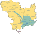
English: Map of Mykolaiv Oblast showing the rough zones of occupation during the southern offensive of the 2022 Russian invasion of Ukraine, as of August 2022. Ukraine (    ) has maintained control over the north of the oblast. The Russian occupation (    ) currently controls the whole of Kinburn Peninsula; in which includes the village of Vasylivka. Russian Armed Forces also formerly occupied large parts of Mykolaiv Raion including some parts of Mykolaiv, the capital city of the Oblast, as well as some border areas of Bashtanka Raion and also areas of Voznesensk Raion. These areas however would soon be recaptured by Ukraine. Russia occupied the areas around Snihurivka and most of the extreme southeast of the oblast until November 2022, when they were liberated as part of the Ukrainian southern counteroffensive. (    )
Date
Source

Own work, derivate of

Author
Physeters
Other versions

[edit]

SVG Maps
  • Autonomous Republic of Crimea
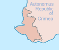
    Autonomous Republic of Crimea
  • Chernihiv Oblast
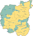
    Chernihiv Oblast
  • Donetsk Oblast
    Donetsk Oblast
  • Kharkiv Oblast
    Kharkiv Oblast
  • Kherson Oblast
    Kherson Oblast
  • Kherson Oblast Hatched
    Kherson Oblast Hatched
  • Kyiv Oblast
    Kyiv Oblast
  • Luhansk Oblast
    Luhansk Oblast
  • Mykolaiv Oblast
    Mykolaiv Oblast
  • Sumy Oblast
    Sumy Oblast
  • Zaporizhzhia Oblast
    Zaporizhzhia Oblast
  • Zaporizhzhia Oblast Hatched
    Zaporizhzhia Oblast Hatched
  • Zhytomyr Oblast
    Zhytomyr Oblast
PNG Maps
  • Autonomous Republic of Crimea
    Autonomous Republic of Crimea
  • Chernihiv Oblast
    Chernihiv Oblast
  • Chernihiv Oblast Peak
    Chernihiv Oblast Peak
  • Dnipropetrovsk Oblast
    Dnipropetrovsk Oblast
  • Dnipropetrovsk Oblast
    Dnipropetrovsk Oblast
  • Dnipropetrovsk & Poltava Oblasts
    Dnipropetrovsk & Poltava Oblasts
  • Donetsk Oblast
    Donetsk Oblast
  • Donetsk Oblast
    Donetsk Oblast
  • Kharkiv Oblast
    Kharkiv Oblast
  • Kharkiv Oblast Control Evolution
    Kharkiv Oblast Control Evolution
  • Kharkiv Oblast
    Kharkiv Oblast
  • Kherson Oblast
    Kherson Oblast
  • Kherson Oblast
    Kherson Oblast
  • Kyiv City
    Kyiv City
  • Kyiv Oblast
    Kyiv Oblast
  • Kyiv Oblast
    Kyiv Oblast
  • Luhansk Oblast
    Luhansk Oblast
  • Luhansk Oblast
    Luhansk Oblast
  • Mykolaiv Oblast
    Mykolaiv Oblast
  • Mykolaiv Oblast Control Evolution
    Mykolaiv Oblast Control Evolution
  • Mykolaiv Oblast
    Mykolaiv Oblast
  • Odesa Oblast
    Odesa Oblast
  • Poltava Oblast
    Poltava Oblast
  • Poltava Oblast
    Poltava Oblast
  • Sevastopol
    Sevastopol
  • Sumy Oblast
    Sumy Oblast
  • Sumy Oblast
    Sumy Oblast
  • Zaporizhzhia Oblast
    Zaporizhzhia Oblast
  • Zaporizhzhia Oblast
    Zaporizhzhia Oblast
  • Zaporizhzhia Oblast Frontline
    Zaporizhzhia Oblast Frontline
  • Zhytomyr Oblast
    Zhytomyr Oblast
  • Zhytomyr Oblast
    Zhytomyr Oblast
  • Zhytomyr Oblast
    Zhytomyr Oblast
This file is translated using SVG <switch> elements. All translations are stored in the same file! Learn more.

For most Wikipedia projects, you can embed the file normally (without a lang parameter). The Wikipedia will use its language if the SVG file supports that language. For example, the German Wikipedia will use German if the SVG file has German. To embed this file in a particular language use the lang parameter with the appropriate language code, e.g. [[File:Russian Occupation of Mykolaiv Oblast.svg|lang=en]] for the English version. Do not specify a lang parameter if it is not needed. The parameter may prevent the use of a subsequent translation.

To translate the text into your language, you can use the

Graphics Lab
if you're not sure how to do this.

Licensing

I, the copyright holder of this work, hereby publish it under the following license:
w:en:Creative Commons
attribution share alike
This file is licensed under the Creative Commons Attribution-Share Alike 4.0 International license.
You are free:
  • to share – to copy, distribute and transmit the work
  • to remix – to adapt the work
Under the following conditions:
  • attribution – You must give appropriate credit, provide a link to the license, and indicate if changes were made. You may do so in any reasonable manner, but not in any way that suggests the licensor endorses you or your use.
  • share alike – If you remix, transform, or build upon the material, you must distribute your contributions under the same or compatible license as the original.

Captions

Map of Russian occupation zones in Mykolaiv Oblast

Items portrayed in this file

depicts

31 August 2022

image/svg+xml

File history

Click on a date/time to view the file as it appeared at that time.

(newest | oldest) View (newer 10 | ) (10 | 20 | 50 | 100 | 250 | 500)
Date/TimeThumbnailDimensionsUserComment
current15:53, 11 November 2022Thumbnail for version as of 15:53, 11 November 20221,134 × 1,043 (107 KB)Basque mappingUpdate per https://liveuamap.com/
01:02, 11 November 2022Thumbnail for version as of 01:02, 11 November 20221,134 × 1,043 (107 KB)DinoSoupCanadaReverted to version as of 00:47, 11 November 2022 (UTC)
01:01, 11 November 2022Thumbnail for version as of 01:01, 11 November 20222,497 × 2,458 (1.27 MB)DinoSoupCanadaUpdate
00:47, 11 November 2022Thumbnail for version as of 00:47, 11 November 20221,134 × 1,043 (107 KB)PhysetersReverted to version as of 00:29, 11 November 2022 (UTC) Good faith edit, but as of Thursday evening, there is no confirmation that the Russians have completely withdrawn from this part of Mykolaiv Oblast
00:32, 11 November 2022Thumbnail for version as of 00:32, 11 November 20221,134 × 1,043 (106 KB)TimetorockknowlegeUpdated to reflect the withdrawal from the Oblast with the exception of Vasylivka east of the Dnipro
00:29, 11 November 2022Thumbnail for version as of 00:29, 11 November 20221,134 × 1,043 (107 KB)PhysetersUpdates per ISW
00:16, 10 November 2022Thumbnail for version as of 00:16, 10 November 20221,134 × 1,043 (108 KB)PhysetersUpdates per the ISW & detailed map
04:39, 8 October 2022Thumbnail for version as of 04:39, 8 October 20221,134 × 1,043 (107 KB)Physeterssmall update per ISW
00:47, 4 October 2022Thumbnail for version as of 00:47, 4 October 20221,134 × 1,043 (107 KB)Physetersadd Pervomaiske
20:39, 16 September 2022Thumbnail for version as of 20:39, 16 September 20221,134 × 1,043 (106 KB)PhysetersUpdates per ISW
(newest | oldest) View (newer 10 | ) (10 | 20 | 50 | 100 | 250 | 500)
The following pages on the English Wikipedia use this file (pages on other projects are not listed):

Global file usage

Metadata