
File:Second Fitna Territorial Control Map ca 686.svg

Size of this PNG preview of this SVG file: 800 × 521 pixels. Other resolutions: 320 × 209 pixels | 640 × 417 pixels | 1,024 × 667 pixels | 1,280 × 834 pixels | 2,560 × 1,668 pixels | 1,880 × 1,225 pixels.
Original file (SVG file, nominally 1,880 × 1,225 pixels, file size: 1.67 MB)
| This is a file from the Wikimedia Commons. Information from its description page there is shown below. Commons is a freely licensed media file repository. You can help. |
Summary
| Description |
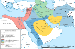
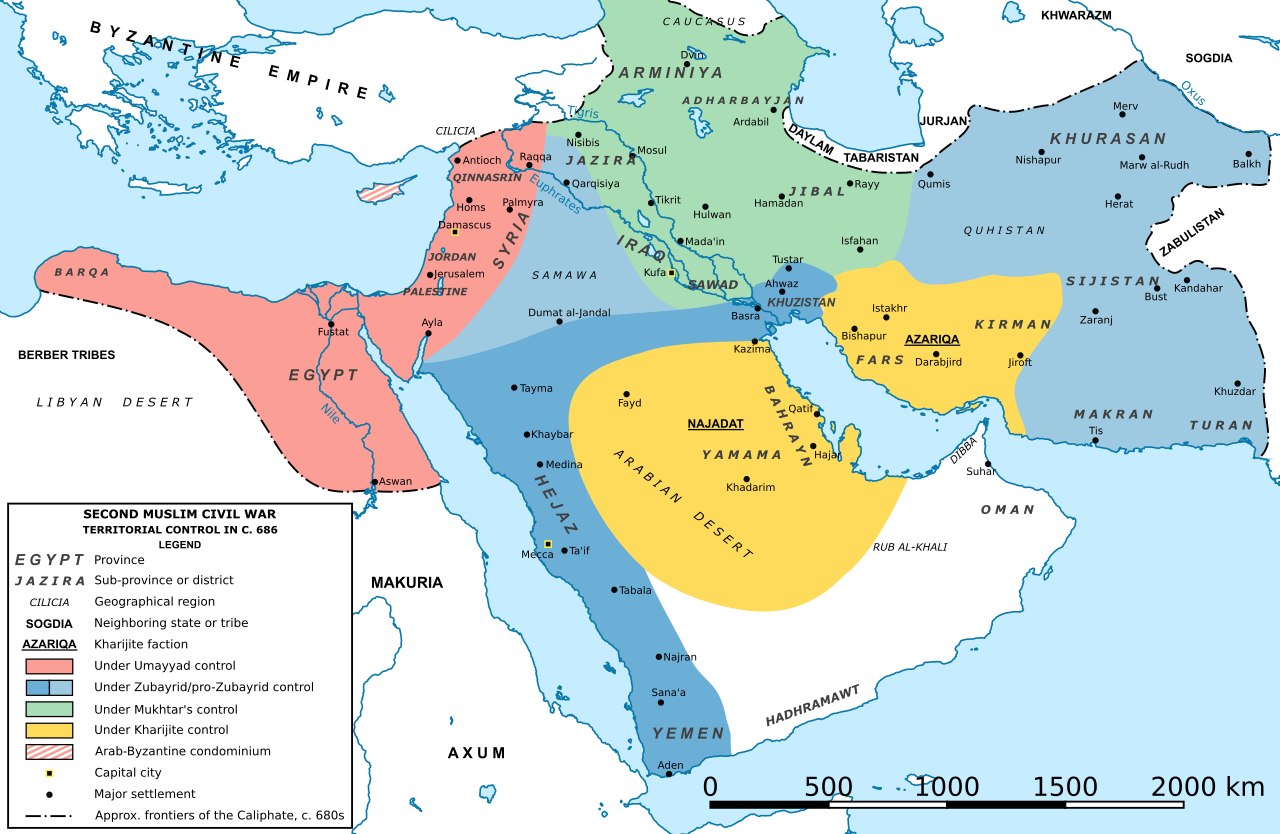
English: Map of the Caliphate during the Second Fitna (Second Muslim Civil War), showing the approximate areas of control of:
Français : Carte du califat durant la fr:Deuxième Fitna. |
| Date | |
| Source | Own work based on: Second Fitna Territorial Control Map ca 686.png by Al Ameer son. For description and sources, cf. there. |
| Author | original map by Al Ameer son; SVG version by Konstantinos Plakidas |
| Other versions |


Licensing
I, the copyright holder of this work, hereby publish it under the following license:
This file is licensed under the Creative Commons Attribution-Share Alike 4.0 International license.
- You are free:
- to share – to copy, distribute and transmit the work
- to remix – to adapt the work
- Under the following conditions:
- attribution – You must give appropriate credit, provide a link to the license, and indicate if changes were made. You may do so in any reasonable manner, but not in any way that suggests the licensor endorses you or your use.
- share alike – If you remix, transform, or build upon the material, you must distribute your contributions under the same or compatible license as the original.
File history
Click on a date/time to view the file as it appeared at that time.
| Date/Time | Thumbnail | Dimensions | User | Comment | |
|---|---|---|---|---|---|
| current | 15:02, 22 August 2022 | | 1,880 × 1,225 (1.67 MB) | Ravenpuff | Make land white instead of transparent – conventional and allows for greater versatility |
| 09:21, 8 November 2019 |  | 1,880 × 1,225 (1.67 MB) | Cplakidas | fixing stripes in Cyprus | |
| 19:37, 7 October 2019 |  | 1,880 × 1,225 (1.66 MB) | Cplakidas | User created page with UploadWizard |
File usage
The following pages on the English Wikipedia use this file (pages on other projects are not listed):
- 680s
- 685
- Abd al-Malik ibn Marwan
- Ibn al-Ash'ath
- Islamic history of Yemen
- Kharijites
- List of revolutions and rebellions
- Marwan I
- Mukhtar al-Thaqafi
- Mus'ab ibn al-Zubayr
- Rashidun cavalry
- Second Fitna
- Umayyad Caliphate
- Urwa ibn al-Zubayr
- Zufar ibn al-Harith al-Kilabi
- User:Falcaorib
- Wikipedia:Featured and good topic candidates/Featured log/February 2020
- Wikipedia:Featured and good topic candidates/Good log/February 2020
- Wikipedia:Featured and good topic candidates/Second Fitna/archive1
- Wikipedia:Featured topics/Second Fitna
- Wikipedia:Good topics/Warfare
- Wikipedia:Main Page history/2020 November 25
- Wikipedia:Main Page history/2020 November 25b
- Wikipedia:Main Page history/2022 August 25
- Wikipedia:Main Page history/2022 August 25b
- Wikipedia:Today's featured article/August 2022
- Wikipedia:Today's featured article/August 25, 2022
- Wikipedia:Today's featured article/November 2020
- Wikipedia:Today's featured article/November 25, 2020
- Wikipedia talk:Featured article candidates/Marwan I/archive1
- Wikipedia talk:Featured article candidates/Zufar ibn al-Harith al-Kilabi/archive1
Global file usage
The following other wikis use this file:
- Usage on bn.wikipedia.org
- Usage on ca.wikipedia.org
- Usage on de.wikipedia.org
- Usage on es.wikipedia.org
- Usage on fa.wikipedia.org
- Usage on fr.wikipedia.org
- Usage on id.wikipedia.org
- Marwan bin al-Hakam
- Khawarij
- Perang Saudara Islam II
- Wikipedia:Artikel pilihan/Jadwal/Usulan/2020
- Wikipedia:Artikel pilihan/Jadwal/Usulan/2020/Periode 3
- Wikipedia:Artikel pilihan/Daftar artikel pilihan 2020
- Wikipedia:Artikel Pilihan/12 2020
- Wikipedia:Arsip halaman utama/2020/03/16
- Wikipedia:Arsip halaman utama/2020/03/17
- Wikipedia:Arsip halaman utama/2020/03/18
- Wikipedia:Arsip halaman utama/2020/03/19
- Wikipedia:Arsip halaman utama/2020/03/20
- Wikipedia:Arsip halaman utama/2020/03/21
- Wikipedia:Arsip halaman utama/2020/03/22
- Usage on it.wikipedia.org
- Usage on ja.wikipedia.org
- Usage on ka.wikipedia.org
- Usage on mk.wikipedia.org
- Usage on nl.wikipedia.org
- Usage on pnb.wikipedia.org
- Usage on ru.wikipedia.org
- Usage on sv.wikipedia.org
- Usage on tr.wikipedia.org
- Usage on uk.wikipedia.org
- Usage on ur.wikipedia.org
- Usage on uz.wikipedia.org
- Usage on www.wikidata.org
- Usage on zh.wikipedia.org