
File:Sg-map.png
No higher resolution available.
Sg-map.png (324 × 348 pixels, file size: 9 KB, MIME type: image/png)
| This is a file from the Wikimedia Commons. Information from its description page there is shown below. Commons is a freely licensed media file repository. You can help. |

|
This locator map image could be re-created using vector graphics as an SVG file. This has several advantages; see Commons:Media for cleanup for more information. If an SVG form of this image is available, please upload it and afterwards replace this template with
{{vector version available|new image name}}.
It is recommended to name the SVG file “Sg-map.svg”—then the template Vva ) does not need the new image name parameter. |
| Description |
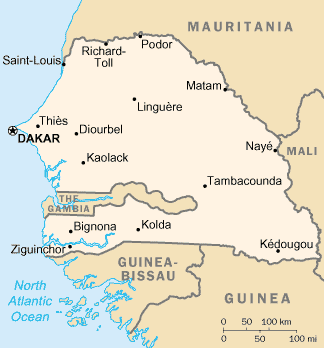
English: senegal map |
| Date | |
| Source | CIA Worldfactory |
| Author | Dubaduba |
| Other versions |
Derivative works of this file: Sg-map-sv.png - |
This image is in the public domain because it contains materials that originally came from the United States Central Intelligence Agency's World Factbook.
|
 |
File history
Click on a date/time to view the file as it appeared at that time.
| Date/Time | Thumbnail | Dimensions | User | Comment | |
|---|---|---|---|---|---|
| current | 01:48, 20 May 2014 | | 324 × 348 (9 KB) | Ras67 | cropped |
| 19:36, 13 June 2005 |  | 328 × 354 (10 KB) | Dubaduba~commonswiki | {{PD-USGov-CIA-WF}} Category:Senegal |
File usage
The following pages on the English Wikipedia use this file (pages on other projects are not listed):
Global file usage
The following other wikis use this file:
- Usage on am.wikipedia.org
- Usage on ar.wikipedia.org
- Usage on ast.wikipedia.org
- Usage on azb.wikipedia.org
- Usage on bg.wikipedia.org
- Usage on bs.wikipedia.org
- Usage on ca.wikipedia.org
- Resolució 294 del Consell de Seguretat de les Nacions Unides
- Resolució 178 del Consell de Seguretat de les Nacions Unides
- Resolució 204 del Consell de Seguretat de les Nacions Unides
- Resolució 273 del Consell de Seguretat de les Nacions Unides
- Resolució 321 del Consell de Seguretat de les Nacions Unides
- Usage on dsb.wikipedia.org
- Usage on eo.wikipedia.org
- Usage on es.wikipedia.org
- Usage on et.wikipedia.org
- Usage on fa.wikipedia.org
- Usage on fi.wikipedia.org
- Usage on fi.wikivoyage.org
- Usage on fr.wikipedia.org
- Usage on he.wikipedia.org
- Usage on hu.wikipedia.org
- Usage on hu.wiktionary.org
- Usage on is.wikipedia.org
- Usage on it.wikipedia.org
- Usage on ja.wikipedia.org
- Usage on ka.wikipedia.org
- Usage on kk.wikipedia.org
- Usage on lb.wikipedia.org
- Usage on lt.wikipedia.org
- Usage on mdf.wikipedia.org
- Usage on ml.wikipedia.org
- Usage on ms.wikipedia.org
- Usage on nl.wikipedia.org
- Usage on no.wikipedia.org
- Usage on pl.wikipedia.org
- Usage on pt.wikipedia.org
- Usage on ro.wikipedia.org
- Usage on ru.wikipedia.org
View more global usage of this file.