
Search results
The page "File:South Cape Mendocino" does not exist. You can ask for it to be uploaded, but consider checking the search results below to see whether the topic is already covered.
 DescriptionSouth Cape Mendocino SMR Rosy Rockfish (16287600674).jpg CDFW Photo taken from the ROV Beagle - South Cape Mendocino State Marine Reserve 2014...(2,592 × 1,944 (2.41 MB)) - 14:32, 19 June 2024
 DescriptionSouth Cape Mendocino SMR Basket Star (16908412312).jpg CDFW Photo taken from the ROV Beagle - South Cape Mendocino State Marine Reserve 2014...(2,592 × 1,944 (2.49 MB)) - 10:42, 20 May 2024
 DescriptionSouth Cape Mendocino SMR Kelp Greenling (16702686977).jpg CDFW Photo taken from the ROV Beagle - South Cape Mendocino State Marine Reserve...(2,592 × 1,944 (1.83 MB)) - 12:52, 26 June 2024
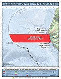 DescriptionSouth Cape Mendocino & Sugarloaf Island.jpeg English: A map of the South Cape Mendocino State Marine Reserve and Sugarloaf Island, California...(1,700 × 2,200 (342 KB)) - 15:49, 3 October 2020
 History of Mendocino and Lake counties, California, with biographical sketches of the leading, men and women of the counties who have been identified...(845 × 1,212 (57.39 MB)) - 19:31, 21 May 2024
 Description English: [Cape Mendocino] Bound sheet. Col. ms. Additional Places: California. From a book of sailing directions of 110ff: 'The South Sea Waggoner...(6,756 × 5,314 (102.71 MB)) - 03:21, 1 February 2024
 Hand-book and directory of Napa, Lake, Sonoma and Mendocino counties, including a map of each county .. ( ) Author Paulson, L. L. (Luther L.), comp...(902 × 1,502 (45.95 MB)) - 22:18, 27 May 2022
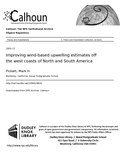 North and South America ( ) Author Pickett, Mark H. Title Improving wind-based upwelling estimates off the west coasts of North and South America Publisher...(1,275 × 1,650 (5.77 MB)) - 06:15, 27 September 2020
 Description English: [Cape Mendocino]Bound sheet. Col. ms. Additional Places: California. >From a book of sailing directions of 110ff: 'The South Sea Waggoner...(1,280 × 1,031 (374 KB)) - 03:21, 1 February 2024
 File:Numerical simulations of the California Current- filament formation as related to baroclinic instability. (IA numericalsimulat00oliv).pdf (matches file content)made to identify the factor(s) responsible for filament formation south of Cape Mendocino by numerically simulating the California Current System using a...(1,152 × 1,554 (4.38 MB)) - 23:10, 14 May 2024
 File:Wind stress and wind stress curl over the California current. (IA windstresswindst00nels).pdf (matches file content)to 1.0 offshore from Cape Blanco. Near Cape Mendocino, this ratio varies between 0.02 and 0.10. values adjacent to the coast south of 40° N latitude...(1,266 × 1,652 (9.71 MB)) - 19:44, 2 May 2024
 currents between Cape Mendocino and Point Arena; and a region of maximum eddy kinetic energy inshore of tilde 125 deg W between Cape Mendocino and Point Arena...(1,168 × 1,620 (4.07 MB)) - 06:22, 19 December 2021
 western boundary, an exaggerated response of the surface circulation to the Mendocino escarpment and the absence of a significant poleward surface current along...(1,200 × 1,616 (3.72 MB)) - 20:18, 22 July 2022
 File:Forest tree seed collection zones in California (IA foresttreeseedco51fowe).pdf (matches file content)hemlock, Sitka spruce, grand fir, and Port Orford white cedar. South of Cape Mendocino the redwood stands are generally of lower site and contain principally...(1,077 × 1,508 (330 KB)) - 21:45, 19 January 2022
 File:Evaluation of COAMPS performance forecasting along coast wind events during a frontal passage (IA evaluationofcoam109452281).pdf (matches file content)frontal case. The four points chosen were (going from North to South) were Cape Mendocino, Point Reyes, Point Sur, and Point Conception. Figure 2. Chart...(1,275 × 1,650 (1.84 MB)) - 15:43, 16 October 2020
 Current, seasonal variability off Baja California, and the meandering jet south of Cape Blanco. The model includes a realistic coastline and is forced from...(1,179 × 1,608 (6.17 MB)) - 22:22, 14 May 2024
 The Admiralty list of lights in South America and on the western coast of North America [microform] : corrected to January, 1867 ( ) Author Dunsterville...(1,125 × 1,333 (873 KB)) - 06:39, 9 March 2022
 northern boundary increases in horizontal and vertical scale as it meanders south through the domain. Cyclones and anticyclones are shown to have preferred...(1,275 × 1,650 (29 MB)) - 18:25, 3 May 2024
 File:The Gull (IA v21n5gullv21ngold).pdf (matches file content)Petrolia to Capetown, the road borders a fine beach for several miles south of Cape Mendocino, an austere headland. After nearing Capetown, we were in (to us)...(979 × 1,568 (248 KB)) - 13:53, 3 December 2022
 File:1. Submarine valleys on the Pacific Coast of the United States. 2. Standard geodetic data. 3. Early Spanish voyages of discovery on the coast of California (IA 1submarinevalley00davirich).pdf (matches file content)as little as forty or fifty miles of the Coast to the southward of Cape Mendocino. The descent to these profound depths is not uniform, however, except...(881 × 1,354 (1.56 MB)) - 19:13, 16 December 2023
.jpg)
.jpg)
.jpg)


