
File:Staines West railway station.jpg
No higher resolution available.
Staines_West_railway_station.jpg (640 × 480 pixels, file size: 77 KB, MIME type: image/jpeg)
| This is a file from the Wikimedia Commons. Information from its description page there is shown below. Commons is a freely licensed media file repository. You can help. |
Summary
| Description |
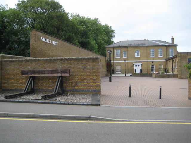
English: The former Staines West railway station, Middlesex (now Surrey), seen from the north. The station had one platform, which was on the left and had a canopy that ran part of the length of the high wall. There was a second track parallel to the platform that was not used for trains in passenger service. The buffer stop on the left is not in its original position. Some rails are embedded in the car park surface, but not in their original positions. |
| Date | |
| Source | From geograph.org.uk |
| Author | Nigel Cox |
| Attribution (required by the license) | Nigel Cox / Staines: Former Staines West railway station (2) / |
| Camera location | | View this and other nearby images on: OpenStreetMap |
|---|
_heading:180.00&language=en)
| Object location | | View this and other nearby images on: OpenStreetMap |
|---|
_heading:180.00&language=en)
Licensing

|
This image was taken from the
Creative Commons Attribution-ShareAlike 2.0 license. |
This file is licensed under the Creative Commons Attribution-Share Alike 2.0 Generic license.
Attribution: Nigel Cox
- You are free:
- to share – to copy, distribute and transmit the work
- to remix – to adapt the work
- Under the following conditions:
- attribution – You must give appropriate credit, provide a link to the license, and indicate if changes were made. You may do so in any reasonable manner, but not in any way that suggests the licensor endorses you or your use.
- share alike – If you remix, transform, or build upon the material, you must distribute your contributions under the same or compatible license as the original.
File history
Click on a date/time to view the file as it appeared at that time.
| Date/Time | Thumbnail | Dimensions | User | Comment | |
|---|---|---|---|---|---|
| current | 09:57, 1 October 2010 | | 640 × 480 (77 KB) | Lamberhurst | == {{int:filedesc}} == {{Information |description={{en|1=This is the rear of {{w|Staines West railway station}}. Nick Catford's great website has an image of the station in 1968, three years after closure here Link Evidently the railway was double-tracked |
File usage
The following pages on the English Wikipedia use this file (pages on other projects are not listed):