
File:Stone circle on Moel Ty-uchaf - geograph.org.uk - 385370.jpg
No higher resolution available.
Stone_circle_on_Moel_Ty-uchaf_-_geograph.org.uk_-_385370.jpg (640 × 451 pixels, file size: 143 KB, MIME type: image/jpeg)
| This is a file from the Wikimedia Commons. Information from its description page there is shown below. Commons is a freely licensed media file repository. You can help. |
Summary
| Description |
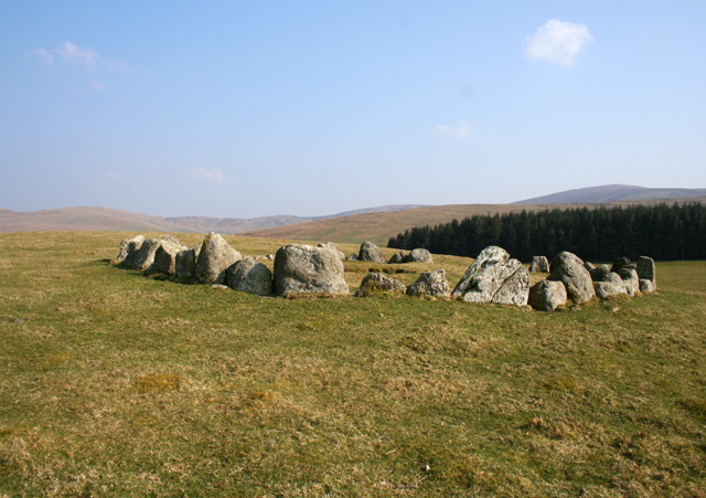
English: Stone circle on Moel Ty-uchaf, near to Llandrillo, Denbighshire/Sir Ddinbych, Wales.
A well-preserved ring of 41 stones on the summit of the hill of Moel Ty-uchaf (440m); the gap (far side, right) is thought to be the original entrance to the circle. Several cairns also surround the south-west flanks of the hill (not visible). Coed Gerynant plantation is on the right, with the ridge up to Cadair Bronwen (right) on the horizon |
| Date | |
| Source | From geograph.org.uk; transferred by User:svejk74 using geograph_org2commons. |
| Author | Espresso Addict |
| Permission (Reusing this file) |
Creative Commons Attribution Share-alike license 2.0 |
| Camera location | | View this and other nearby images on: OpenStreetMap |
|---|
| Object location | | View this and other nearby images on: OpenStreetMap |
|---|
_region:GB-GBN_heading:157.00&language=en)
Licensing

|
This image was taken from the
Creative Commons Attribution-ShareAlike 2.0 license. |
This file is licensed under the Creative Commons Attribution-Share Alike 2.0 Generic license.
Attribution: Espresso Addict
- You are free:
- to share – to copy, distribute and transmit the work
- to remix – to adapt the work
- Under the following conditions:
- attribution – You must give appropriate credit, provide a link to the license, and indicate if changes were made. You may do so in any reasonable manner, but not in any way that suggests the licensor endorses you or your use.
- share alike – If you remix, transform, or build upon the material, you must distribute your contributions under the same or compatible license as the original.
File history
Click on a date/time to view the file as it appeared at that time.
| Date/Time | Thumbnail | Dimensions | User | Comment | |
|---|---|---|---|---|---|
| current | 19:26, 25 October 2010 | | 640 × 451 (143 KB) | File Upload Bot (Magnus Manske) |
File usage
The following pages on the English Wikipedia use this file (pages on other projects are not listed):
Global file usage
The following other wikis use this file:
- Usage on cy.wikipedia.org
- Usage on de.wikipedia.org
- Usage on el.wikipedia.org
- Usage on fr.wikipedia.org