
File:Surface map NE US CANADA 2013122018.gif
No higher resolution available.
Surface_map_NE_US_CANADA_2013122018.gif (750 × 562 pixels, file size: 28 KB, MIME type: image/gif)
| This is a file from the Wikimedia Commons. Information from its description page there is shown below. Commons is a freely licensed media file repository. You can help. |
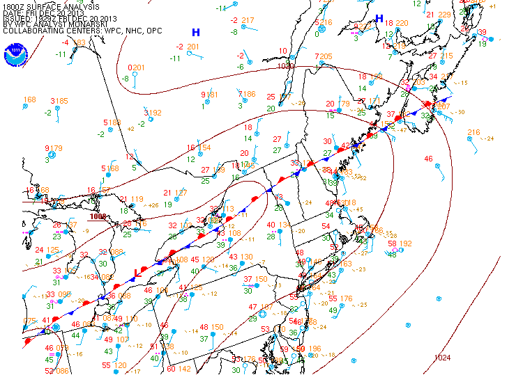
Summary
| Description |
English: Surface weather map of Dsecember 20, 2013, at 18 UTC for the 2013 Central and Eastern Canada ice storm.
Français : Carte météorologique de surface pour 18 UTC le 20 décembre 2013 lors du Verglas massif de décembre 2013 dans le nord-est de l'Amérique du Nord. |
| Date | |
| Source | http://nomads.ncdc.noaa.gov/ncep/NCEP |
| Author | National Centers for Environmental Prediction (NCEP) from NOAA |
Licensing
This image is in the public domain because it contains materials that originally came from the U.S. National Oceanic and Atmospheric Administration, taken or made as part of an employee's official duties.
|
File history
Click on a date/time to view the file as it appeared at that time.
| Date/Time | Thumbnail | Dimensions | User | Comment | |
|---|---|---|---|---|---|
| current | 2013 Central and Eastern Canada ice storm .}} {{fr|1=Carte météorologique de surface pour 18 UTC le 20... |
File usage
The following pages on the English Wikipedia use this file (pages on other projects are not listed):
Global file usage
The following other wikis use this file:
- Usage on fr.wikipedia.org