
File:Tectonic map Europe.jpg
Size of this preview: 505 × 599 pixels. Other resolutions: 202 × 240 pixels | 404 × 480 pixels | 647 × 768 pixels | 1,270 × 1,507 pixels.
Original file (1,270 × 1,507 pixels, file size: 757 KB, MIME type: image/jpeg)
| This is a file from the Wikimedia Commons. Information from its description page there is shown below. Commons is a freely licensed media file repository. You can help. |
Summary
| Description |
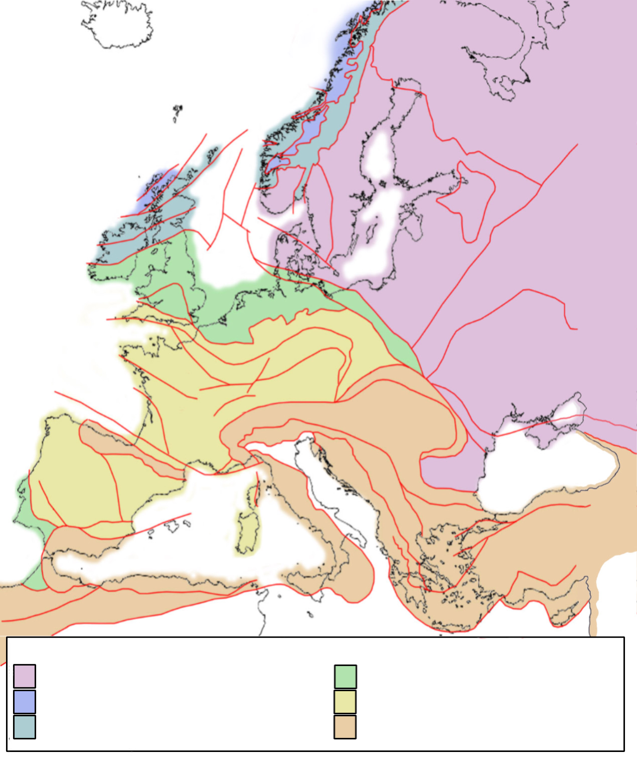
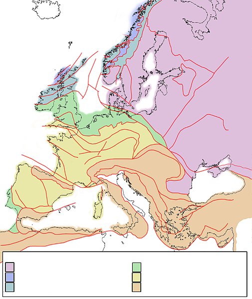
English: Tectonic framework map of Europe, showing the major tectonic provinces. Purple = Baltica crust; blue = Laurentia crust, deformed by Caledonian orogeny; greenblue = Baltica crust, deformed by Caledonian orogeny; green = Avalonia crust; yellow = terrains deformed by Hercynian/Variscan orogeny; orange = terrains deformed by Alpine orogeny. NOTE: see discussion page how to add text to this map. |
| Date | |
| Source | Own work |
| Author | Woudloper |
| Other versions | Derivative works of this file: Tectonic Map of Europe noleg.jpg |
Licensing
| I, the copyright holder of this work, release this work into the public domain. This applies worldwide. In some countries this may not be legally possible; if so: I grant anyone the right to use this work for any purpose, without any conditions, unless such conditions are required by law. |
File history
Click on a date/time to view the file as it appeared at that time.
| Date/Time | Thumbnail | Dimensions | User | Comment | |
|---|---|---|---|---|---|
| current | 11:27, 18 September 2022 | | 1,270 × 1,507 (757 KB) | Рагин1987 | Extended map |
| 11:58, 30 July 2008 |  | 1,270 × 1,506 (332 KB) | Woudloper | {{Information |Description={{en|1=Tectonic framework map of Europe, showing the major tectonic provinces. Purple = Baltica crust; blue = Laurentia crust, deformed by Caledonian orogeny; greenblue = Baltica crust, deformed by Caledonian orogeny; green = Av | |
| 10:50, 30 July 2008 |  | 1,270 × 1,506 (333 KB) | Woudloper | == Summary == {{Information |Description={{en|1=Tectonic framework map of Europe, showing the major tectonic provinces. Purple = Baltica crust; blue = Laurentia crust, deformed by Caledonian orogeny; greenblue = Baltica crust, deformed by Caledonian oroge | |
| 10:11, 30 July 2008 |  | 1,270 × 1,270 (360 KB) | Woudloper | {{Information |Description={{en|1=Tectonic framework map of Europe, showing the major tectonic provinces. Purple = Baltica crust; blue = Laurentia crust, deformed by Caledonian orogeny; greenblue = Baltica crust, deformed by Caledonian orogeny; green = Av |
File usage
The following pages on the English Wikipedia use this file (pages on other projects are not listed):
Global file usage
The following other wikis use this file:
- Usage on da.wikipedia.org
- Usage on de.wikipedia.org
- Usage on es.wikipedia.org
- Usage on gl.wikipedia.org
- Usage on it.wikipedia.org
- Usage on nl.wikipedia.org
- Usage on ru.wikipedia.org
- Usage on sv.wikipedia.org
- Usage on uk.wikipedia.org