
File:The ruins of Plean House - geograph.org.uk - 160341.jpg
No higher resolution available.
The_ruins_of_Plean_House_-_geograph.org.uk_-_160341.jpg (640 × 480 pixels, file size: 375 KB, MIME type: image/jpeg)
| This is a file from the Wikimedia Commons. Information from its description page there is shown below. Commons is a freely licensed media file repository. You can help. |
Summary
| Description |
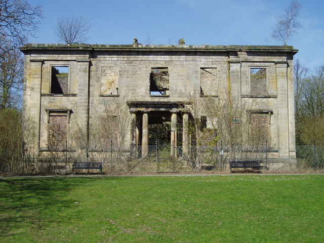
English: The ruins of Plean House. This ruin which was built around 1800 and destroyed by fire in 1972, sits within Plean Country Park which was established in the 1980's. The ruin is now unsafe but was originally built by Francis Simpson who was a Ship's Captain with The Honourable East India Company. |
| Date | |
| Source | From geograph.org.uk |
| Author | Kevin Rae |
| Attribution (required by the license) | Kevin Rae / The ruins of Plean House / |
| Camera location | | View this and other nearby images on: OpenStreetMap |
|---|
_heading:45.00&language=en)
| Object location | | View this and other nearby images on: OpenStreetMap |
|---|
_heading:45.00&language=en)
Licensing

|
This image was taken from the
Creative Commons Attribution-ShareAlike 2.0 license. |
This file is licensed under the Creative Commons Attribution-Share Alike 2.0 Generic license.
Attribution: Kevin Rae
- You are free:
- to share – to copy, distribute and transmit the work
- to remix – to adapt the work
- Under the following conditions:
- attribution – You must give appropriate credit, provide a link to the license, and indicate if changes were made. You may do so in any reasonable manner, but not in any way that suggests the licensor endorses you or your use.
- share alike – If you remix, transform, or build upon the material, you must distribute your contributions under the same or compatible license as the original.
File history
Click on a date/time to view the file as it appeared at that time.
| Date/Time | Thumbnail | Dimensions | User | Comment | |
|---|---|---|---|---|---|
| current | 12:53, 31 January 2010 | | 640 × 480 (375 KB) | GeographBot | == {{int:filedesc}} == {{Information |description={{en|1=The ruins of Plean House. This ruin which was built around 1800 and destroyed by fire in 1972, sits within Plean Country Park which was established in the 1980's. The ruin is now unsafe but was orig |
File usage
The following pages on the English Wikipedia use this file (pages on other projects are not listed):
Global file usage
The following other wikis use this file:
- Usage on de.wikipedia.org
- Usage on sco.wikipedia.org
- Usage on www.wikidata.org