
File:UNsierraleone.PNG

Original file (2,293 × 2,895 pixels, file size: 1.71 MB, MIME type: image/png)
| This is a file from the Wikimedia Commons. Information from its description page there is shown below. Commons is a freely licensed media file repository. You can help. |
Summary
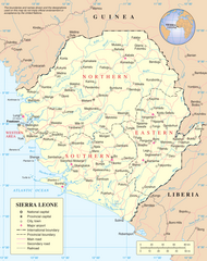
Map of Sierra Leone.
Source: http://www.un.org/Depts/Cartographic/map/profile/sierrale.pdf
| This image is a map derived from a United Nations map.
Unless stated otherwise, UN maps are to be considered in the public domain. This applies worldwide. UN maps are, in principle, open source material and you can use them in your work or for making your own map. UN requests however that you delete the UN name, logo and reference number upon any modification to the map. Content of your map will be your responsibility. You can state in your publication, if you wish, something like: based on UN map … (map name, map number, revision number and date). See: Geospatial Information Section. And: Geospatial, location data for a better world. |
 |
File history
Click on a date/time to view the file as it appeared at that time.
| Date/Time | Thumbnail | Dimensions | User | Comment | |
|---|---|---|---|---|---|
| current | 14:04, 8 July 2023 | | 2,293 × 2,895 (1.71 MB) | Lojwe | Cropped 2 % horizontally, 2 % vertically using CropTool with precise mode. |
| 02:11, 23 October 2007 |  | 2,349 × 2,947 (1.7 MB) | Jeroen | Much higher resolution. | |
| 00:57, 9 January 2006 |  | 615 × 773 (176 KB) | Taichi | Map of Sierra Leone. Source: http://www.un.org/Depts/Cartographic/map/profile/sierrale.pdf {{PD-UN}} Category:Sierra Leone |
File usage
- List of cities in Sierra Leone
- Mano, Sierra Leone
- Operation Barras
- Outline of Sierra Leone
- Sierra Leone
- United Nations Security Council Resolution 1132
- United Nations Security Council Resolution 1270
- United Nations Security Council Resolution 1688
- User:MarioGom/sandbox/Missing P21 German
- User:Northamerica1000/Topics
- Portal:Sierra Leone/Selected picture
- Portal:Sierra Leone/Selected picture/6
Global file usage
The following other wikis use this file:
- Usage on ar.wikipedia.org
- Usage on avk.wikipedia.org
- Usage on azb.wikipedia.org
- Usage on az.wikipedia.org
- Usage on bg.wikipedia.org
- Usage on bn.wikipedia.org
- Usage on ca.wikipedia.org
- Sierra Leone
- Guerra Civil de Sierra Leone
- Resolució 1132 del Consell de Seguretat de les Nacions Unides
- Resolució 1270 del Consell de Seguretat de les Nacions Unides
- Resolució 1299 del Consell de Seguretat de les Nacions Unides
- Resolució 1400 del Consell de Seguretat de les Nacions Unides
- Resolució 1492 del Consell de Seguretat de les Nacions Unides
- Resolució 1508 del Consell de Seguretat de les Nacions Unides
- Resolució 1537 del Consell de Seguretat de les Nacions Unides
- Resolució 1610 del Consell de Seguretat de les Nacions Unides
- Missió de les Nacions Unides a Sierra Leone
- Resolució 1620 del Consell de Seguretat de les Nacions Unides
- Oficina Integral de les Nacions Unides a Sierra Leone
- Resolució 1829 del Consell de Seguretat de les Nacions Unides
- Oficina de les Nacions Unides per a la Consolidació de la Pau a Sierra Leone
- Resolució 1940 del Consell de Seguretat de les Nacions Unides
- Usage on ckb.wikipedia.org
- Usage on el.wikipedia.org
- Usage on es.wikipedia.org
- Usage on fa.wikipedia.org
- Usage on fi.wikipedia.org
- Usage on fr.wikipedia.org
- Usage on he.wikipedia.org
- Usage on id.wikipedia.org
- Usage on is.wikipedia.org
- Usage on it.wikipedia.org
View more global usage of this file.