
File:United Kingdom police areas map.svg

Size of this PNG preview of this SVG file: 405 × 599 pixels. Other resolutions: 162 × 240 pixels | 324 × 480 pixels | 519 × 768 pixels | 692 × 1,024 pixels | 1,384 × 2,048 pixels | 871 × 1,289 pixels.
Original file (SVG file, nominally 871 × 1,289 pixels, file size: 2.64 MB)
| This is a file from the Wikimedia Commons. Information from its description page there is shown below. Commons is a freely licensed media file repository. You can help. |
| Description |
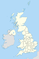
Map showing the Police areas of the United Kingdom in 2011. Equirectangular map projection on WGS 84 datum, with N/S stretched 170% Geographic limits:
|
| Date | |
| Source |
Ordnance Survey OpenData Boundary-Line:
|
| Author | Nilfanion, created using Ordnance Survey data |
| Permission (Reusing this file) |
This file is licensed under the Creative Commons Attribution-Share Alike 3.0 Unported license. Attribution: Contains Ordnance Survey data © Crown copyright and database right
|
| Other versions |
Derivative works of this file: |
File history
Click on a date/time to view the file as it appeared at that time.
| Date/Time | Thumbnail | Dimensions | User | Comment | |
|---|---|---|---|---|---|
| current | 14:15, 18 February 2023 | | 871 × 1,289 (2.64 MB) | Turbo Slayer 2021 | Oops, I found the Wrong Map, my appologies :( |
| 14:13, 18 February 2023 |  | 871 × 1,289 (2.39 MB) | Turbo Slayer 2021 | Reverted to version as of 11:33, 12 October 2011 (UTC) | |
| 10:49, 20 April 2013 |  | 871 × 1,289 (2.64 MB) | Aight 2009 | police scotland is established | |
Police areas of the United Kingdom in 2011. Equirectangular map projection on WGS 84 datum, with N/S stretched 170% Geographic limits: *West: 11.0W *East: 2.2E *North: 61.0N *South: 49.0N |So |
File usage
The following pages on the English Wikipedia use this file (pages on other projects are not listed):