
File:Vancouver Skytrain and Seabus Map.svg

Size of this PNG preview of this SVG file: 512 × 295 pixels. Other resolutions: 320 × 184 pixels | 640 × 369 pixels | 1,024 × 590 pixels | 1,280 × 738 pixels | 2,560 × 1,475 pixels.
Original file (SVG file, nominally 512 × 295 pixels, file size: 980 KB)
| This is a file from the Wikimedia Commons. Information from its description page there is shown below. Commons is a freely licensed media file repository. You can help. |
Summary
| Description |
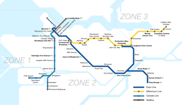
English: A map of the rapid transit network of Metro Vancouver with RapidBus and West Coast Express transfers |
| Date | |
| Source | Own work |
| Author | Zacharycmango |
Licensing
I, the copyright holder of this work, hereby publish it under the following license:
This file is licensed under the Creative Commons Attribution-Share Alike 4.0 International license.
- You are free:
- to share – to copy, distribute and transmit the work
- to remix – to adapt the work
- Under the following conditions:
- attribution – You must give appropriate credit, provide a link to the license, and indicate if changes were made. You may do so in any reasonable manner, but not in any way that suggests the licensor endorses you or your use.
- share alike – If you remix, transform, or build upon the material, you must distribute your contributions under the same or compatible license as the original.
File history
Click on a date/time to view the file as it appeared at that time.
| Date/Time | Thumbnail | Dimensions | User | Comment | |
|---|---|---|---|---|---|
| current | 21:14, 20 January 2024 | | 512 × 295 (980 KB) | Deathying | Added R6 Scott Road to the diagram, new RapidBus connection introduced Jan 2024. |
| 01:33, 29 May 2022 |  | 512 × 295 (972 KB) | Zacharycmango | Uploaded own work with UploadWizard |
File usage
The following pages on the English Wikipedia use this file (pages on other projects are not listed):
Global file usage
The following other wikis use this file:
- Usage on fi.wikipedia.org
- Usage on ku.wikipedia.org
- Usage on pl.wikipedia.org
- Usage on zh-yue.wikipedia.org