
File:Verwaltung Kanton Zürich 17.png

Size of this preview: 410 × 599 pixels. Other resolutions: 164 × 240 pixels | 329 × 480 pixels.
Original file (800 × 1,168 pixels, file size: 331 KB, MIME type: image/png)
| This is a file from the Wikimedia Commons. Information from its description page there is shown below. Commons is a freely licensed media file repository. You can help. |
Summary
| Description |
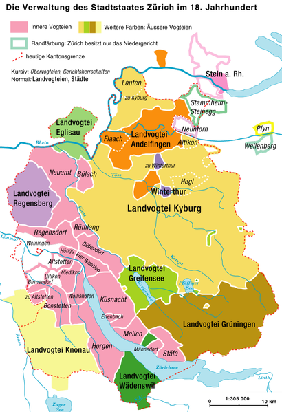
Deutsch: Die Verwaltungsgliederung des Staatstaates Zürich im 18. Jahrhundert |
|
| Date | ||
| Source | Own work | |
| Author | Marco Zanoli (sidonius 13:20, 20 January 2007 (UTC)) | |
| Permission (Reusing this file) |
|
|
| Other versions |
 |
File history
Click on a date/time to view the file as it appeared at that time.
| Date/Time | Thumbnail | Dimensions | User | Comment | |
|---|---|---|---|---|---|
| current | 05:07, 4 July 2010 | | 800 × 1,168 (331 KB) | DcoetzeeBot | Remove watermark, add author and license data to image metadata, decrease filesize with pngcrush |
| 14:58, 8 April 2008 |  | 800 × 1,168 (404 KB) | Sidonius | ||
| 16:20, 7 April 2008 |  | 800 × 1,168 (406 KB) | Sidonius | kleine Korrekturen, farblich überarbeitet | |
| 13:20, 20 January 2007 |  | 800 × 1,168 (309 KB) | Sidonius | {{Information |Description={{de|Die Verwaltungsgliederung des Staatstaates Zürich im 18. Jahrhundert}} |Source=own work |Date=20.1.2007 |Author=Marco Zanoli (~~~~) |Permission={{Attribution sidonius}} |other_versions= }} [[Category:Maps o |
File usage
The following pages on the English Wikipedia use this file (pages on other projects are not listed):
Global file usage
The following other wikis use this file:
- Usage on de.wikipedia.org
- Usage on fr.wikipedia.org
- Usage on ps.wikipedia.org
- Usage on sl.wikipedia.org