
File:West Florida Map 1767.svg

Size of this PNG preview of this SVG file: 115 × 79 pixels. Other resolutions: 320 × 220 pixels | 640 × 440 pixels | 1,024 × 703 pixels | 1,280 × 879 pixels | 2,560 × 1,759 pixels.
Original file (SVG file, nominally 115 × 79 pixels, file size: 539 KB)
| This is a file from the Wikimedia Commons. Information from its description page there is shown below. Commons is a freely licensed media file repository. You can help. |
Summary
| Description |
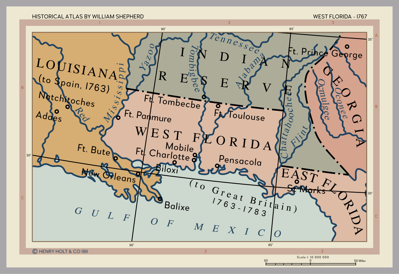
English: Cropped from the map 'The British Colonies in North America, 1763-1775' from the Historical Atlas by William Shepherd (1911) - available from the Perry-Castañeda Library Map Collection [1]. |
| Date | |
| Source | Own work |
| Author | Rattyrattery |
Licensing
I, the copyright holder of this work, hereby publish it under the following license:
| This file is made available under the Creative Commons CC0 1.0 Universal Public Domain Dedication. | |
| The person who associated a work with this deed has dedicated the work to the public domain by waiving all of their rights to the work worldwide under copyright law, including all related and neighboring rights, to the extent allowed by law. You can copy, modify, distribute and perform the work, even for commercial purposes, all without asking permission.
|
File history
Click on a date/time to view the file as it appeared at that time.
| Date/Time | Thumbnail | Dimensions | User | Comment | |
|---|---|---|---|---|---|
| current | 18:47, 31 March 2021 | | 115 × 79 (539 KB) | Rattyrattery | Font families changed |
| 18:07, 31 March 2021 |  | 115 × 79 (286 KB) | Rattyrattery | Converted bold text to objects | |
| 18:04, 31 March 2021 |  | 115 × 79 (234 KB) | Rattyrattery | Converted text on paths to objects, extended several rivers | |
| 17:54, 31 March 2021 |  | 115 × 79 (128 KB) | Rattyrattery | Uploaded own work with UploadWizard |
File usage
The following pages on the English Wikipedia use this file (pages on other projects are not listed):
Global file usage
The following other wikis use this file:
- Usage on ar.wikipedia.org
- Usage on arz.wikipedia.org
- Usage on br.wikipedia.org
- Usage on ca.wikipedia.org
- Usage on da.wikipedia.org
- Usage on de.wikipedia.org
- Usage on es.wikipedia.org
- Usage on fr.wikipedia.org
- Usage on gl.wikipedia.org
- Usage on he.wikipedia.org
- Usage on id.wikipedia.org
- Usage on it.wikipedia.org
- Usage on ja.wikipedia.org
- Usage on ko.wikipedia.org
- Usage on mk.wikipedia.org
- Usage on mt.wikipedia.org
- Usage on no.wikipedia.org
- Usage on pt.wikipedia.org
- Usage on ro.wikipedia.org
- Usage on ru.wikipedia.org
- Usage on sv.wikipedia.org
- Usage on vi.wikipedia.org
- Usage on zh.wikipedia.org