
File:Ynys Gifftan - geograph.org.uk - 142069.jpg
No higher resolution available.
Ynys_Gifftan_-_geograph.org.uk_-_142069.jpg (640 × 480 pixels, file size: 71 KB, MIME type: image/jpeg)
| This is a file from the Wikimedia Commons. Information from its description page there is shown below. Commons is a freely licensed media file repository. You can help. |
Summary
| Description |
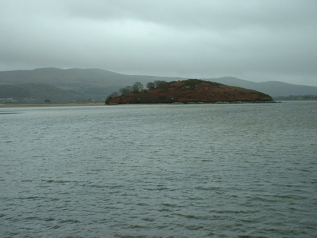
English: Ynys Gifftan. This is an island near the south east shore of Traeth Bach, the Dwyryd estuary. There is a public footpath to it across the estuary, but passable only at low tide - and even then, the water is usually at or above knee level. It's an exciting expedition to visit this now uninhabited island. There is a derelict farmhouse there, and some sheep grazing is still used. |
| Date | |
| Source | From geograph.org.uk |
| Author | David Medcalf |
| Attribution (required by the license) | David Medcalf / Ynys Gifftan / |
| Camera location | | View this and other nearby images on: OpenStreetMap |
|---|
_&language=en)
| Object location | | View this and other nearby images on: OpenStreetMap |
|---|
_&language=en)
Licensing

|
This image was taken from the
Creative Commons Attribution-ShareAlike 2.0 license. |
This file is licensed under the Creative Commons Attribution-Share Alike 2.0 Generic license.
Attribution: David Medcalf
- You are free:
- to share – to copy, distribute and transmit the work
- to remix – to adapt the work
- Under the following conditions:
- attribution – You must give appropriate credit, provide a link to the license, and indicate if changes were made. You may do so in any reasonable manner, but not in any way that suggests the licensor endorses you or your use.
- share alike – If you remix, transform, or build upon the material, you must distribute your contributions under the same or compatible license as the original.
File history
Click on a date/time to view the file as it appeared at that time.
| Date/Time | Thumbnail | Dimensions | User | Comment | |
|---|---|---|---|---|---|
| current | 11:12, 31 January 2010 | | 640 × 480 (71 KB) | GeographBot | == {{int:filedesc}} == {{Information |description={{en|1=Ynys Gifftan. This is an island near the south east shore of Traeth Bach, the Dwyryd estuary. There is a public footpath to it across the estuary, but passable only at low tide - and even then, the |
File usage
The following pages on the English Wikipedia use this file (pages on other projects are not listed):
Global file usage
The following other wikis use this file:
- Usage on cy.wikipedia.org
- Usage on fr.wikipedia.org
- Usage on www.wikidata.org