
File:ZDF-Hochhaus Mainz 20211105 HOF0779900001020211121 RAW-Exportcens.jpg

Size of this preview: 489 × 599 pixels. Other resolutions: 196 × 240 pixels | 392 × 480 pixels | 627 × 768 pixels | 836 × 1,024 pixels | 1,672 × 2,048 pixels | 4,784 × 5,861 pixels.
Original file (4,784 × 5,861 pixels, file size: 15.6 MB, MIME type: image/jpeg)
| This is a file from the Wikimedia Commons. Information from its description page there is shown below. Commons is a freely licensed media file repository. You can help. |
Summary
| Description |
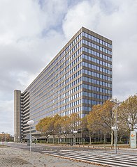
Deutsch: Ansicht des ZDF-Hochhauses im ZDF-Sendezentrum in Mainz-Lerchenberg an einem bewölkten Herbsttag.
English: View of the ZDF high-rise building at the ZDF broadcasting center in Mainz-Lerchenberg on a cloudy autumn day.
日本語: 秋の曇り空の日、マインツ・レルヒェンベルグにあるZDF放送局センターのZDF高層ビルの風景。
Español: Vista del rascacielos de la ZDF en el centro de emisión de la ZDF en Maguncia-Lerchenberg en un día nublado de otoño.
中文:秋天多云的日子里,位于美因茨-莱辛堡的ZDF广播中心的ZDF高层建筑的景色。
Svenska: Vy över ZDF:s höghus vid ZDF:s sändningscenter i Mainz-Lerchenberg en molnig höstdag.
Русский: Вид на высотное здание вещательного центра ZDF в Майнц-Лерхенберге в пасмурный осенний день. |
| Date | |
| Source | Own work |
| Author | PantheraLeo1359531 |
| Camera location | | View this and other nearby images on: OpenStreetMap |
|---|
Licensing
I, the copyright holder of this work, hereby publish it under the following license:
This file is licensed under the Creative Commons Attribution 4.0 International license.
- You are free:
- to share – to copy, distribute and transmit the work
- to remix – to adapt the work
- Under the following conditions:
- attribution – You must give appropriate credit, provide a link to the license, and indicate if changes were made. You may do so in any reasonable manner, but not in any way that suggests the licensor endorses you or your use.
This image has been assessed using the Quality image guidelines and is considered a Quality image.
|
File history
Click on a date/time to view the file as it appeared at that time.
| Date/Time | Thumbnail | Dimensions | User | Comment | |
|---|---|---|---|---|---|
| current | 19:39, 12 January 2022 | | 4,784 × 5,861 (15.6 MB) | PantheraLeo1359531 | Fix |
| 19:35, 12 January 2022 |  | 4,784 × 5,861 (15.61 MB) | PantheraLeo1359531 | Zweige rechts entfernt | |
| 13:52, 9 January 2022 |  | 4,784 × 5,861 (15.57 MB) | PantheraLeo1359531 | Crop | |
| 20:25, 22 November 2021 |  | 8,384 × 6,261 (29.68 MB) | PantheraLeo1359531 | Reverted to version as of 20:23, 22 November 2021 (UTC) | |
| 20:25, 22 November 2021 |  | 9,504 × 6,336 (38.76 MB) | PantheraLeo1359531 | Ausgangsfoto | |
| 20:23, 22 November 2021 |  | 8,384 × 6,261 (29.68 MB) | PantheraLeo1359531 | Perspektivkorrektur | |
| 19:58, 22 November 2021 |  | 9,504 × 6,336 (39.55 MB) | PantheraLeo1359531 | Uploaded own work with UploadWizard |
File usage
The following pages on the English Wikipedia use this file (pages on other projects are not listed):
Global file usage
The following other wikis use this file:
- Usage on ar.wikipedia.org
- Usage on ast.wikipedia.org
- Usage on ca.wikipedia.org
- Usage on cs.wikipedia.org
- Usage on de.wikipedia.org
- Usage on diq.wikipedia.org
- Usage on es.wikipedia.org
- Usage on fa.wikipedia.org
- Usage on fi.wikipedia.org
- Usage on fr.wikipedia.org
- Usage on ga.wikipedia.org
- Usage on gl.wikipedia.org
- Usage on hy.wikipedia.org
- Usage on id.wikipedia.org
- Usage on it.wikipedia.org
- Usage on ja.wikipedia.org
- Usage on ko.wikipedia.org
- Usage on lv.wikipedia.org
- Usage on nds.wikipedia.org
- Usage on pt.wikipedia.org
- Usage on ru.wikipedia.org
- Usage on sv.wikipedia.org
- Usage on tr.wikipedia.org
- Usage on uk.wikipedia.org
- Usage on www.wikidata.org
- Usage on zh.wikipedia.org