
File:Zones of Bhutan.svg

Size of this PNG preview of this SVG file: 800 × 435 pixels. Other resolutions: 320 × 174 pixels | 640 × 348 pixels | 1,024 × 557 pixels | 1,280 × 696 pixels | 2,560 × 1,393 pixels | 875 × 476 pixels.
Original file (SVG file, nominally 875 × 476 pixels, file size: 254 KB)
| This is a file from the Wikimedia Commons. Information from its description page there is shown below. Commons is a freely licensed media file repository. You can help. |
| Description | Divisione amministrativa del Bhutan con colorazione degli Dzongdey |
| Date | (UTC) |
| Source | |
| Author |
|
| Other versions | Derivative works of this file: Dzongkha native language districts.svg |
| This is a retouched picture, which means that it has been digitally altered from its original version. Modifications: SVG version. The original can be viewed here: Bhutan-distretti-numerato.png:
|
This file is licensed under the Creative Commons Attribution 3.0 Unported license.
- You are free:
- to share – to copy, distribute and transmit the work
- to remix – to adapt the work
- Under the following conditions:
- attribution – You must give appropriate credit, provide a link to the license, and indicate if changes were made. You may do so in any reasonable manner, but not in any way that suggests the licensor endorses you or your use.
Original upload log
This image is a derivative work of the following images:
- File:Bhutan-distretti-numerato.png licensed with PD-self
- 2010-02-08T08:52:48Z PhiLiP 800x449 (51107 Bytes) new edition
- 2007-12-09T18:38:44Z Ysogo 800x449 (37003 Bytes) {{Information |Description=Divisione amministrativa del Bhutan con colorazione degli Dzongdey |Source=self-made;versione precedente (Made by Nichalp 18:52, August 8, 2005 (UTC) + Modifica di Reddy (inserimento numerazione |Da
Uploaded with derivativeFX
File history
Click on a date/time to view the file as it appeared at that time.
| Date/Time | Thumbnail | Dimensions | User | Comment | |
|---|---|---|---|---|---|
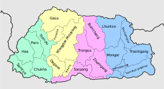
| current | 07:41, 18 October 2010 | | 875 × 476 (254 KB) | Babbage | == {{int:filedesc}} == == {{int:filedesc}} == Zones of Bhutan, color coded in accordance with article text |
| 20:10, 17 October 2010 |  | 900 × 700 (71 KB) | Babbage | {{Information |Description=Divisione amministrativa del Bhutan con colorazione degli Dzongdey |Source=*File:Bhutan-distretti-numerato.png |Date=2010-10-17 20:08 (UTC) |Author=*File:Bhutan-distretti-numerato.png: Ysogo *derivativ |
File usage
The following pages on the English Wikipedia use this file (pages on other projects are not listed):
Global file usage
The following other wikis use this file:
- Usage on bn.wikipedia.org
- Usage on el.wikipedia.org
- Usage on eo.wikipedia.org
- Usage on gn.wikipedia.org
- Usage on ja.wikipedia.org
- Usage on ka.wikipedia.org
- Usage on ru.wikipedia.org
- Usage on tr.wikipedia.org
- Usage on uk.wikipedia.org
- Usage on uz.wikipedia.org
- Usage on zh.wikipedia.org