
Firth of Clyde
This article needs additional citations for verification. (May 2007) |
| Firth of Clyde | |
|---|---|
Isle of Cumbrae |


The Firth of Clyde is the mouth of the River Clyde. It is located on the west coast of Scotland and constitutes the deepest coastal waters in the British Isles (it is 164 metres deep at its deepest).[where?] The firth is sheltered from the Atlantic Ocean by the Kintyre peninsula, which encloses the outer firth in Argyll and Ayrshire. The Kilbrannan Sound is a large arm of the Firth of Clyde, separating the Kintyre Peninsula from the Isle of Arran. Within the Firth of Clyde is another major island – the Isle of Bute. Given its strategic location at the entrance to the middle and upper Clyde, Bute played a vital naval military role during World War II.
Geography
At its entrance, the firth is about 25 miles (40 km) wide.
The geographical (and popular) distinction between the firth and the River Clyde is vague. Some refer to Dumbarton as being "on the Firth of Clyde". At the same time, the residents of Port Glasgow and Greenock often refer to the part of the firth that lies to the north of those areas as "the river". In Scottish Gaelic the landward end of the firth is called Linne Chluaidh (pronounced [ˈʎiɲə ˈxlˠ̪uəj]; meaning the same as the English), while the area around the south of Arran, Kintyre and Ayrshire/Galloway is An Linne Ghlas [ə ˈʎiɲə ˈɣlˠ̪as̪].
The Firth encompasses many
Cowal Peninsula
The Cowal peninsula extends into the Firth of Clyde and forms the main western shoreline of the upper firth.[3] The main town on the Cowal peninsula is Dunoon.
Ferries
Traveling by ferry across the Firth of Clyde saves time compared to traveling "round by road", via
).The service between
Towns and villages along the shoreline

Here is a list of the major towns and some of the numerous villages along the firth (but not along the River Clyde or the connecting lochs):
- Ardrossan, Ayr
- Barassie, Brodick
- Cardross, Carradale
- Dumbarton, Dunoon
- Fairlie
- Gourock, Greenock, Girvan
- Hunter's Quay
- Innellan, Inverkip, Irvine
- Kirn
- Lamlash, Largs, Lochranza
- Millport
- Port Bannatyne, Portencross, Port Glasgow, Prestwick
- Rothesay
- Strone
- Toward, Troon
- Wemyss Bay, West Kilbride, Whiting Bay
Islands in the Clyde
There are many islands in the firth. The largest ones all have thriving communities and regular ferry services connecting them to the mainland. They are:


Sea lochs off the Clyde

- Gare Loch
- Loch Long, and Loch Goil
- The Holy Loch at Sandbank on the Cowal Peninsula
- Loch Striven
- Loch Riddon off the Kyles of Bute
- Loch Fyne, Loch Gilp and Loch Shira
- Loch Ranza
- Campbeltown Loch
- Loch Ryan
- East Loch Tarbert
- Loch Gair
History
The Clyde has been an important sea route from the earliest times. For example, the Battle of Largs, which was fought there in 1263, was a geopolitical turning point: It marked the end of Norse ambitions in Britain.[9] Beginning in the 16th century, the Clyde increasingly became a conduit for commercial and industrial products, including: herring; timber; wine; sugar; tobacco; textiles; iron and steel; coal; oil; industrial chemicals; distillation and brewing; ships, locomotives, and other vehicles; and other manufactured products.
In the middle of the 19th century, the sport of yachting became popular on the Clyde. The area became famous worldwide for its significant contribution to yachting and yachtbuilding with notable designers including: William Fife III; Alfred Mylne; G L Watson; David Boyd. It was also the location of many famous yacht yards. Clyde-built wooden yachts are still known for quality and style today.
With the advent of
The "lower Clyde" shipyards of Greenock and Port Glasgow, most notably Scott Lithgow, played an important historical role in shipbuilding. The PS Comet was the first successful steamboat in Europe, and, until well into the 20th century, a large proportion of the world's ships were built there.
During World War II, Glasgow and the Clyde became the main entry point in Britain for the Allied forces’ merchant shipping, military personnel, and equipment, and for the assembly, despatch, and control of their ocean convoys. The Clyde also hosted the country's largest naval base. In 1942, a submarine oil pipeline that had been laid across the Firth of Clyde was the site of Operation Pluto, the world's first deep-water test of its kind. This was one of many innovations designed to support air, maritime, and territorial combat during World War II.
Today, tourism, sport and recreation, and heritage history continue to attract visitors from across the world. The steam-powered
In recent times, the natural environment of the firth has been compromised in places by a succession of industrial and military developments along the shoreline, including the
-
 Ferguson Shipbuilders, the last shipyard on the Lower Clyde, close by Newark Castle, Port Glasgow, at the upper end of the firth
 -
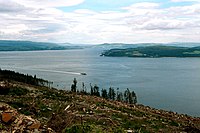 The inner firth seen from the Cowal peninsula near Dunoon, looking northeast to the coast of Inverclyde at Cloch point, south of Gourock and Greenock, and beyond that the Tail of the Bank. PS Waverley can be seen cruising south "doon the watter"


Nature and conservation
| Clyde Sill MPA(NC) | |
|---|---|
Marine Scotland |
On Great Cumbrae, there is a marine biological station, run jointly by the University of Glasgow and the University of London.
are much less common, some were spotted in the upper reaches of the firth in the summer of 2005.Also, in 2005, the firth had the second-highest number of basking shark sightings in Scotland (after the Minch). These huge sharks seem to particularly favour the warm, shallow waters surrounding Pladda.
However, although commercial fishing was at one time intensive in the Firth's many fishing towns, today the only catches of commercial interest remaining in the Clyde waters are prawns, lobsters, herring, mussels, and crayfish.
In September 2008, Scotland's first No Take Zone (NTZ) was introduced in Lamlash Bay, on the Isle of Arran. This was the result of a community effort, led by the Community of Arran Seabed Trust (C.O.A.S.T). The NTZ was introduced specifically to protect delicate marine communities such as maerl. Maerl is a very slow-growing coral-like calcareous red algae (it grows only 1 mm per year). It is an important Scottish species. Maerl beds are reservoirs of biodiversity and are crucial nursery grounds for young scallops and young fish. Studies have shown that both scallop dredging and organic waste from fish farms significantly reduce the live maerl population. Scallop dredging on a maerl bed has been found to kill over 70% of live maerl. Monitoring the bed over the next four years found no discernible recovery, suggesting that maerl beds would require many years free of disturbance in order to recover.
In 2014, 71,200 hectares (712 km2) of sea at the mouth of firth between Kintyre and the Rhins of Galloway was declared a Nature Conservation Marine Protected Area, designated Clyde Sill MPA(NC).[10] The MPA covers a distinctive sill at the mouth of the firth, where the warmer, fresher water of the Clyde mixes with the cooler, more saline water of the North Channel. This is a rich environment for plankton, which provide food for fish that are in turn eaten by higher marine predators and seabirds.[11]
Shipping in the Firth
The Firth of Clyde, like the River Clyde, has historically been an important centre of shipbuilding and shipping. Upriver, there have been shipbuilding and engineering centres at Glasgow, Govan, Clydebank, Dumbarton, and Renfrew. Downriver, there have been major yards at Greenock and Port Glasgow; smaller yards at Irvine, Ardrossan, Troon, and Campbeltown; and various other boatyards, including those at Hunters Quay, Port Bannatyne, and Fairlie. Today, the Ferguson Marine shipbuilding yard, adjacent to Newark Castle, Port Glasgow, is the last merchant shipbuilder on the Clyde, and it is owned by the Scottish Government.[citation needed] In Greenock, the large dry dock and ship-repair facilities at Inchgreen opened in 1964, and were subsequently taken over by Scott Lithgow. The dry dock there is 305 m long and 44 m wide. With the demise of Scott Lithgow, the facilities came under the management of Clydeport, which, along with Cammell Laird, is now part of Peel Ports Group.
The Firth of Clyde has one of the deepest sea-entrance channels in Northern Europe.[clarification needed] It can accommodate the largest Capesize vessels afloat today. As a result, the Clyde was one of the UK's leading ports, handling some 7.5 million tonnes of cargo each year.[citation needed] Hunterston Terminal was constructed to bring in bulk ore, but later mainly dealt with coal imports, and closed in 2016.[12] Supertankers up to 324,000 tonnes travel up the firth to deliver crude oil to Finnart Oil Terminal in Loch Long, which is connected by pipeline to the Grangemouth Refinery on the Firth of Forth. A second pipeline brings back refined oil products for export (in smaller oil tankers) mainly to Northern Ireland.[13]
The Royal Navy has a significant presence on the Clyde, both at HMNB Clyde on the Gare Loch, and on Loch Long, connected to the nuclear storage facilities in Coulport and at Glen Douglas. The dockyard engineering and operations are managed by Babcock International. One of the three main ports that provide marine-services support vessels is located at Greenock, and was previously operated directly by the Royal Maritime Auxiliary Service.
-
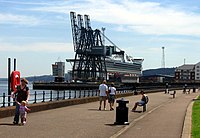
 Atcontainer cranes at Greenock, passing the Caledonian MacBrayne Dunoon ferry. Across the firth MV Kenilworth leaves Kilcreggan for Helensburgh.
 -
 Container cranes at Greenock's Ocean Terminal, with the berth occupied by the cruise shipGolden Princess.
 -
 Container ship mv Encounter (built 2004, callsign PHAO) outbound on the Clyde Estuary, destination Bilbao. Little Cumbrae can be seen on the left.


There are lighthouses at:
- Cloch Point on the Inverclyde coast.[14]
- Toward Point Lighthouse on the Southern tip of the Cowal Peninsula.[15]
- Little Cumbrae[16]
- Pladda[17]
There are navigation beacons at:
- The Gantocks Rocks and Navigation Beacon, off the coast at Dunoon, Cowal Peninsula.[18]
Climate
| Greenock | ||||||||||||||||||||||||||||||||||||||||||||||||||||||||||||
|---|---|---|---|---|---|---|---|---|---|---|---|---|---|---|---|---|---|---|---|---|---|---|---|---|---|---|---|---|---|---|---|---|---|---|---|---|---|---|---|---|---|---|---|---|---|---|---|---|---|---|---|---|---|---|---|---|---|---|---|---|
| Climate chart (explanation) | ||||||||||||||||||||||||||||||||||||||||||||||||||||||||||||
| ||||||||||||||||||||||||||||||||||||||||||||||||||||||||||||
| ||||||||||||||||||||||||||||||||||||||||||||||||||||||||||||
The Firth's maritime climate is considerably milder than contintental locations at the same latitide. Whilst the reason for this mild climate is the subject of debate
See also
References
- Dorling KindersleyLimited. p. 120. Retrieved 27 February 2024.
- ^ C.Michael Hogan. 2011. Irish Sea. eds. P.Saundry & C.Cleveland. Encyclopedia of Earth. National council for Science and the Environment. Washington DC Archived 2 June 2013 at the Wayback Machine
- ^ "Home". visitcowal. 20 June 2014. Retrieved 7 February 2017.
- ^ "CALEDONIAN MARITIME ASSETS LIMITED persons with significant control - Find and update company information - GOV.UK". find-and-update.company-information.service.gov.uk.
- ^ "Corporate". Argyll Ferries Limited. Archived from the original on 2 October 2018. Retrieved 25 June 2020.
- ^ "Train to and from Gourock". www.scotrail.co.uk. Retrieved 1 April 2018.
- ^ "WESTERN FERRIES (CLYDE) LIMITED overview - Find and update company information - GOV.UK". find-and-update.company-information.service.gov.uk.
- ^ "Western Ferries (Clyde) Ltd". www.western-ferries.co.uk. Retrieved 1 April 2018.
- ^ Jon Kelly (8 December 2011). "How Scandinavian is Scotland?". BBC News Magazine. Retrieved 1 March 2019.
- ^ a b "Clyde Sill MPA(NC)". NatureScot. Retrieved 7 October 2020.
- ^ "Clyde Sea Sill Marine Protected Area" (PDF). NatureScot. Archived from the original (PDF) on 10 October 2020. Retrieved 7 October 2020.
- ^ "Hunterston port 'masterplan' revealed promising £140m boost". BBC News. 16 May 2019. Retrieved 16 August 2021.
- ^ Fullarton, Donald (29 July 2011). "Americans built oil terminal". Helensburgh Heritage. Retrieved 23 May 2013.
- ^ Historic Environment Scotland. "Inverkip, The Cloch Lighthouse (123013)". Canmore. Retrieved 7 February 2017.
- ^ Historic Environment Scotland. "Toward Point, Toward Point Lighthouse (68122)". Canmore. Retrieved 7 February 2017.
- ^ Historic Environment Scotland (23 August 1951). "Little Cumbrae Island, New Lighthouse (40680)". Canmore. Retrieved 7 February 2017.
- ^ Historic Environment Scotland (12 July 2010). "Pladda, Lighthouse (40074)". Canmore. Retrieved 7 February 2017.
- ^ Historic Environment Scotland. "The Gantocks, Navigation Beacon (287955)". Canmore. Retrieved 7 February 2017.
- ^ "Climate & Weather Averages in Greenock, Scotland, United Kingdom". Timeanddate.com. Retrieved 9 October 2019.. Data for period 1985–2015.
- ^ "The Gulf Stream Myth". ocp.ldeo.columbia.edu.
- ^ "Weather Facts: Accessory clouds | weatheronline.co.uk". www.weatheronline.co.uk.
Sources
- The Clyde: River and Firth, 1907 and reissued 2010, Neil Munro, with illustrations by Mary Y and Y Young Hunter
- The Firth of Clyde, 1952, George Blake
- Glasgow and the Clyde, 1965, Ward Lock Guide
- Clyde Coast Connections, 2010, Neil Grieves
- From Comet to Cal Mac : Two Centuries of Hebridean and Clyde Shipping, 2011, Donald E Meek and Bruce Peter
- Firth of Clyde: Sailing Directions and Anchorages, 2012, Clyde Cruising Club
- HM Naval Base: Clyde, 2012, Keith Hall
External links
- Map sources for Firth of Clyde
Shipyards of the Clyde | |
|---|---|

Scotts Stephens Fairfield Connell Inglis Denny Beardmore |
| Historic Marine Protected Areas | |
|---|---|
| Nature Conservation MPAs |
|
| Demonstration and Research MPA | |
| International | |
|---|---|
| National | |