
Forbes Creek (Washington)
| Forbes Creek | |
|---|---|
Washington | |
| Region | King County |
| City | Kirkland, Washington |
| Physical characteristics | |
| Source | |
| • coordinates | 47°40′48.5″N 122°10′4″W / 47.680139°N 122.16778°W |
| • elevation | 360 ft (110 m) |
Juanita Bay Park | |
• location | Lake Washington |
• coordinates | 47°41′56″N 122°12′39″W / 47.69889°N 122.21083°W |
• elevation | 16 ft (4.9 m) |
| Length | 2.5 mi (4.0 km) |
| Basin size | 6.6 sq mi (17 km2) |
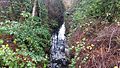
Forbes Creek is a small, moderately sloping creek wholly within the city of Kirkland, Washington.[1] From its headwaters on the Rose Hill moraine to its outlet at Juanita Bay is c. 2 miles (3.2 km) as the crow flies. The northern extent of its basin is a nearly east–west line at NE 116th Street; the eastern boundary is at the Rose Hill ridgeline, roughly north–south at 132nd Avenue NE. The southern extent is irregular trending roughly from Kirkland's high point at the northeast corner of Bridle Trails State Park (535 ft (163 m), 47°39′26″N 122°10′21″W / 47.65722°N 122.17250°W[2]) through South Rose Hill Park, to Lake Washington at 16 feet (4.9 m) above sea level.[3]
Two major branches of the creek rise on Rose Hill between NE 70th Street and NE 85th Street and then run south to north on Rose Hill. One rises in the vicinity of Lake Washington High School and runs north past Costco #008 to Forbes Lake. The other rises slightly to the east in the vicinity of Rose Hill Elementary School then through North Rose Hill Woodlands Park. The two join north of the lake then run west through a two-meter culvert under Interstate 405 near NE 100th Street,[4] under the Cross Kirkland Corridor, into the Forbes Creek Valley and Juanita Bay Wetlands Park. The creek finally empties into Lake Washington at Juanita Bay, less than a kilometer from the mouth of Juanita Creek which empties into the same bay.
Watershed and wetlands
The Forbes Creek watershed is a 1,837-acre (743 ha) drainage basin covering a quarter of Kirkland's total land area.[5] Forbes Creek empties into Lake Washington in the neighborhood of Juanita. Twenty two wetlands exist in the basin, comprising the greatest number and area of wetlands of any creek in Kirkland (there are no rivers).[6]
Plant species
-
 InvasiveHimalayan blackberryand holly in the creekbed mixed with native salal and sword fern undergrowth beneath alder and cedar trees
 -
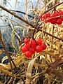 European cranberry on lake shore
 -
 Tree in Forbes Lake Park chewed by beavers
 -
 Beaver in the bay's lily pads
 -
 Birdwatchers on Juanita Bay Park's Lake Washington shoreline


.jpg)

Ice age creation
The landforms and hydrology of the
Forbes Lake
Forbes Lake (47°41′09″N 122°10′47″W / 47.68583°N 122.17972°W) is a 7-acre (2.8 ha), 30-foot (9.1 m) deep

Naming

Forbes Lake is named for the Forbes family of settlers. Dorr Forbes, a Civil War veteran with
Steel mill
Forbes Lake was the site of the
Juanita Bay Park

The wetlands where Forbes Creek enters Lake Washington are Juanita Bay Park, Kirkland's largest city park at 110 acres (45 ha).
The Forbes Creek wetlands are noted as prime urban
The Juanita Bridge, built in 1891 and rebuilt in 1932, carried Market Street wagon traffic, later automobile traffic, across the wetland. It was converted to pedestrian-only use in 1974 when a new bridge was built slightly to the east.[27][28]
References
- ^ Parametrix 2005, p. 19.
- ^ "Kirkland high point". Peakbagger.com. Retrieved December 15, 2016.
- ^ The Watershed Company 1998.
- ^ I-405 Kirkland Nickel Project – Stage 1 Construction Environmental Improvements (Forbes Creek) (PDF), Washington State Department of Transportation, March 2006
- ^ Parametrix 2005, p. 20.
- ^ The Watershed Company 1998, p. 51.
- ^ The Watershed Company 1998, pp. 11, 21, 41, etc..
- ^ Manning, Manning & Spring 2002.
- ^ "Forbes Lake vital statistics", Water and land services small lakes database, King County, Washington, retrieved December 15, 2016
- ^ "A Gift from the Ice Age" interpretive sign, City of Kirkland, 120th Avenue public access on southwest corner of lake.
- ^ U.S. Geological Survey Geographic Names Information System: Forbes Lake
- ^ Worthy and Associates 2009, p. 4.
- ^ "Detail Report: Forbes, Dorr PVT, 33 IL US INF Company E", Illinois Civil War database, Illinois Secretary of State, record 84767, retrieved December 24, 2016
- ^ https://www.kirklandwa.gov/files/sharedassets/public/parks-amp-comm-services/online-parks-guide/pdfs/juanitabeachpark_history.pdf
- ^ Juanita "remember when" map 1900-1918, derived from records and oral history, at Kirkland branch map file, King County Library System
- ^ a b King County Historic Preservation 2002.
- ^ Matthew McCauley, Juanita's First Family, Kirkland Heritage Society
- ^ Ely 1975.
- ^ Manning 1995, p. 61.
- ^ Park guide, City of Kirkland
- ^ Cathy McDonald (January 19, 2011), "Juanita Bay Park is a popular winter walk, well-interpreted", The Seattle Times
- ^ Manning, Manning & Spring 2002, p. 76.
- ^ City of Kirkland 2011.
- ^ Alderfer 2006, p. 12.
- ^ Dolezal 2007, p. 44.
- ^ Stevens & Weber 2016, p. 73.
- ^ Kirkland Historical Tour, Eastside Heritage Center, 2006
- Museum of History and Industry, image 1998.10.39 – via University of Washington digital collections
Bibliography
- Alderfer, Jonathan (2006), National Geographic Field Guide to Birds: Washington & Oregon, National Geographic Books, ISBN 9780792253136
- Dolezal, Robert J. (2007), Where the Birds Are: A Travel Guide to Over 1,000 Parks, Preserves, and Sanctuaries, Reader's Digest Association, ISBN 9780762108602
- Ely, Arline (1975), Our Foundering Fathers (PDF), Kirkland Public Library
- Juanita Bay Park: An Urban Wildlife Habitat (PDF), City of Kirkland, February 1, 2011
- King County Historic Preservation Program (c. 2002), Juanita Beach Park History (PDF) – via City of Kirkland
- ISBN 9780898868227
- Manning, Harvey (1995), Walks and Hikes in the Foothills and Lowlands Around Puget Sound, Mountaineers Books, ISBN 9780898864311
- Parametrix (2005), "Existing Conditions and Problems in Kirkland's Watersheds", Surface Water Master Plan, City of Kirkland, archived from the original on March 7, 2015 (Chapter 3 Archived 2017-02-11 at the Wayback Machine)
- Stevens, Bryce; Weber, Andrew (2016), 60 Hikes Within 60 Miles: Seattle: Including Bellevue, Everett, and Tacoma, Menasha Ridge Press, ISBN 9781634040181
- The Watershed Company (July 1998), "Forbes Creek Basin", Kirkland's Streams, Wetlands and Wildlife Study, pp. 48–58, archived from the original on March 28, 2015 – via City of Kirkland
- Worthy and Associates (March 2009), Forbes Lake Trail and Park Improvements Plan (PDF) – via City of Kirkland
External links
- Forbes Lake Trail and Park Improvements Project Archived 2017-01-18 at the Wayback Machine at Kirkland Parks
- Stream report at King County Department of Natural Resources