
Fort Denison
| Fort Denison | |
|---|---|
Mattewanye ( castellated style | |
| Location | Sydney Harbour |
| Address | North of Woolloomooloo |
| Construction started | 1841 |
| Completed | 14 November 1857 |
| Closed | circa 1930s |
| Height | |
| Observatory | Martello tower |
| Technical details | |
| Material | Sydney sandstone |
 Fort Denison with its Martello tower | |
 Location in Sydney | |
| Location | Port Jackson, Sydney Harbour National Park |
| Nearest city | Sydney |
| Coordinates | 33°51′18″S 151°13′32″E / 33.8549°S 151.2255°E |
| Operator | NSW National Parks & Wildlife Service |
| fortdenison | |
| Official name | Fort Denison; Pinchgut; Mattewanye (Eora name) |
| Type | State heritage (built) |
| Designated | 2 April 1999 |
| Reference no. | 985 |
| Type | Fortification |
| Category | Defence |
| Builders | William Randle |
| Official name | Fort Denison, Sydney, NSW, Australia |
| Designated | 21 March 1978 |
| Reference no. | 1856 |
| References | |
| [1] | |
Fort Denison, part of the
The site contains time gun, navigational aids and tide gauge facilities. Correctional and military facilities were designed by George Barney and built from 1840 to 1862 by William Randle. The property is owned by the Office of Environment & Heritage, an agency of the Government of New South Wales. It was added to the New South Wales State Heritage Register on 2 April 1999.[2] In 1978 the former fortress was listed on the (now defunct) Register of the National Estate,[1] and is currently used as a national park, nature reserve, tourist facility, and as a function space.
History
Prior to European settlement, the island had the Eora name Mattewanye (sometimes Mallee’wonya).[citation needed]
Prison
 | |
| Location | Sydney Harbour, New South Wales, Australia |
|---|---|
| Status | Closed |
| Security class | Maximum; isolation |
| Opened | 1788 |
| Former name | Rock Island |
| Managed by | New South Wales Colonial Government |
After the First Fleet arrived in 1788, Governor Phillip and his advocate-general used the name "Rock Island". In 1788, a convict named Thomas Hill was sentenced to a week on bread and water in irons there. The island came to be known as "Pinchgut".[3] Once a 15-metre (49 ft) high or higher sandstone islet, the rock was levelled by convicts under the command of Captain George Barney, the civil engineer for the colony, who quarried it for sandstone to construct nearby Circular Quay.
In late 1796 the Governor had installed a
Military fortress
In 1839, two American warships entered the harbour at night and circled Pinchgut Island. Concern with the threat of foreign attack caused the government to review the harbour's inner defences. Barney, who had earlier reported that Sydney's defences were inadequate, recommended that the government establish a fort on Pinchgut Island to help protect Sydney Harbour from attack by foreign vessels. Fortification of the island began in 1841 but was not completed. Construction resumed in 1855 because of fear of a Russian naval attack during the Crimean War, and was completed on 14 November 1857. The newly built fort then took its current name from Sir William Thomas Denison, the Governor of New South Wales from 1855 to 1861.
The fortress features a distinctive
Eventually all the guns were removed, except for the three 8-inch (200 mm) muzzle-loading cannons in the gun room in the tower, which were installed before construction was complete. The passages within the tower are too narrow to permit these to be removed. However, from the beginning the three cannons were of limited utility. The embrasures for the cannons were too small to use the guns effectively and by the time a cannon was loaded the ship it was to fire on would have sailed past. Lastly, the guns' recoil was too powerful for the small room.[citation needed]
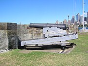
In 1906, a saluting gun (pictured below) was transferred from Dawes Point to Fort Denison.
In 1913 a lighthouse beacon built in Birmingham, England, and shipped to Sydney, replaced the 10-inch (250 mm) gun on the roof of the tower. The light is called Fort Denison Light, which is still in use.

In May 1942, three Japanese
Explosive prank
In October 1900, as the
Current use
Recent restorative works
Since 1992, the NSW National Parks & Wildlife Service, which manages the site, has spent around A$2m conserving and upgrading the facilities. EnergyAustralia also made a significant contribution for the work via the Foundation for National Parks and Wildlife.[8]
Following publication of a conservation plan, further renovation commenced in 1999 and was completed in 2001. The conservation and adaptive re-use of the island was awarded the NSW Royal Australian Institute of Architects (RAIA) Conservation Award; a Commendation in the National RAIA Awards; and a National Trust Heritage Award in 2001.
Increased harbour traffic has already destroyed the slipway. Furthermore, the porous sandstone drinks in the salt right down to the fort's foundations. In 2007 the government announced a $1.5 million rescue package. Fort Denison is now home to more than 100 birds.

Fort Denison is now a museum, tourist attraction, restaurant, and popular location for wedding receptions and corporate events. The tourist facility contains an exhibition of the island's history from Aboriginal times. Access to Fort Denison is via a
In 2004 the NSW National Parks & Wildlife Service restored the lighthouse beacon, which is still in use and supports operation of a Harbour Navigational Facility, with tide gauge, navigation channel markers, foghorn and beacon, established in the mid-19th century. The Bureau of Meteorology operates a weather facility from the island and publishes observations at half-hourly intervals on its website.[9]
The custom of firing a gun daily at 1pm began in 1906 to enable sailors to set their ship's chronometers correctly. The daily gun continued until World War II when the authorities stopped it for fear of alarming residents. The practice recommenced in 1986.[10]
Restaurant on the Island
The Fort Denison Restaurant was opened on the island in 2006, although the restaurant lease expired in June 2017 and is yet to be renewed. Throughout the years since it has been voted in the top five waterfront restaurants worldwide by The Sydney Morning Herald, and was open for lunch seven days a week year round, dinners on a Sunday, and for special events and occasions which can be found on their website.[11] Bookings for major occasions, such as New Year's Eve, were coveted.
Popular culture
Fort Denison was the location of the 1959 film
Description
Fort Denison on Sydney Harbour is within the visual catchment of the Sydney Opera House, the Sydney Harbour Bridge, the Royal Botanic Garden and the Sydney Harbour Naval Precinct.[12][2] Fort Denison is the only Sydney Harbour island which is no longer described as an island. Even Garden Island, now visually part of the mainland (and anything but a garden) is still known as an island. The island known as Mattewanye (small rocky island) to Aborigines and Rock Island to the first settlers, is now popularly known as Fort Denison and viewed as a built artefact rather than an island.[2]
From a distance no evidence of its original island character is apparent, except perhaps scattered rocks at low tide. However, on close inspection the sandstone bedrock visible below the south west battery reveals part of the rock of the island, particularly when combined with the pictorial evidence provided by drawings such as that by Barrington in 1802.[2]
- The Fort
- The visual impact of the fort is a combination of the strong vertical mass of the Martello tower and the equally strong horizontal lines of the low barrack and battery buildings. The two distinct building forms reflects the history of the staged Fort construction; which progressed from the original horizontal form of the battery, and later construction of the barracks and Martello tower. The tower, which only lost its dominant role in marking the water entrance to the city with the construction of the Sydney Opera House, was built with an open gun platform (terreplein) which surmounted two internal levels. A section through the tower, shows the navigational light which replaced the upper cannon in 1913. The lower internal level contained rooms for the storage of gunpowder and provisions and the middle level still houses the three original cannons. Internal tower circulation is via a spiralling staircase that connects the three tower levels. External access to the tower is through a single external door from the upper terrace level battery and bastion.[2]
Three major elements comprise the strong horizontal section of the fort; the battery and bastion, the barracks and terrace.[2] - Gun Battery and Bastion
- The outward facing defensive side of the fort known as the gun battery and bastion confronted incoming ships. It is constructed out of the island's sandstone bedrock. The battery consists of an open working area which services a series of nine gun placements and corresponding slanted firing openings which are equally positioned along the raised parapet wall of the battery. An underground water tank has been cut into the bedrock of the battery. The bastion located at the southern end of the battery was constructed to house a single cannon set behind a raised stone parapet. The cannon was located on a raised circular revolving mount to maximise the cannon's aim of fire.[2]
- Wet Ditch and Breakwater
- A wet ditch and breakwater formed by sandstone blocks separates the fort from the open harbour channel. Beyond this is a breakwater which surrounds the whole island which moderates the wave action against the stone fabric of the fort.[2]
- Barrack
- The main single storey building is the barrack, its eight chimneys indicate its original accommodation purpose. The barracks are built into cut back bedrock and contain a row of single rooms used for military bunk-style accommodation for the lower ranks as well as accommodation for two separate officers' quarters. A central breezeway and vault covered staircase allows access from the barracks and lower terraces to the upper terrace battery, bastion and Martello tower. The two end rooms adjoining the barracks, known as the Tide Gauge Room to the north and the West Room to the south, were constructed soon after the completion of the barracks. The loopholes, or angled openings, were designed to enable the defensive fire whilst defending against enemy attack.[2]
- Terrace
- The lower north west facing terrace is constructed on the same level as the barracks. It was probably built on rubble fill which is contained by a low stone wall.[2]
The terrace is open and not defensive in nature, as it faces away from the open sea and potential attack. It currently has a bitumen surface and several small planted garden beds. Garden beds were constructed on this terrace during the 20th century as part of the domestication of the fort by the Sydney Harbour Trust and later Maritime Services Board caretakers. Two sewerage treatment units which service the toilets are concealed in the garden beds at either end of the barracks.[2][13] - Plantings
- A Canary Island date palm (
Condition
As at 26 May 2014, the physical condition is excellent. Archaeological potential is high.[2] Published material on such towers in the English speaking world suggests that this may well be the most intact tower.[15][2]
Modifications and dates
The following modifications have been made to Fort Denison:[2]
- 1840–1842 – construction of battery
- 1856–1858 – construction of battery, barrack and tower and bastion
- 1858–1862 – construction of terrace, west room and tide gauge room
- 1917 – construction of slipway
Heritage listing
Fort Denison was listed on the New South Wales State Heritage Register on 2 April 1999 .[2]
Tide gauge
Tides have been measured at Fort Denison since 1857 on completion of the fort, initially using a bench mark cut into the stonework of the Martello Tower. From 1867 successive instruments were used as tide measuring technology developed.[16] (The measurements since 1914 are graphed by Bureau of Meteorology).[17]
The Fort Denison photographs below show float activated tide gauge instruments in a cabinet and the system's stilling well.[18] A wire connected to the upper drum mechanism passes out through the bottom right of the cabinet and runs over a pulley to drop down to the float system in the large pipe in the well. This system is now obsolete at Fort Denison but maintained as a museum exhibit. To the right of the large pipe in the well is an enclosed pipe which rises to the active modern system.
Tide heights and times at Fort Denison are the primary base referent for published tide information for other places in the state of New South Wales.
-
 Tide gauge installation: old and new
 -
 Obsolete instruments
 -
 Historic and current (right) stilling wells.


Gallery of guns
-
 Viewing from tower to southern bastion
 -
 Gun – southern bastion
 -
 Gun inscription: Honi soit qui mal y pense
 -
 Gun at east-facing wall
 -
 Gun room in the Martello tower


See also
References
- ^ a b "Fort Denison (Place ID 1856)". Australian Heritage Database. Australian Government. 21 March 1978. Retrieved 18 June 2016.
- ^ .
- ^ Decisions of the Superior Courts of New South Wales, 1788–1899 R. v. Hill [1788 NSWKR 2; [1788] NSWSupC 2. Accessed 7 January 2015. Archived 29 March 2016 at the Wayback Machine
- ^ Australia Today—Fort Denison (Pinchgut): A Relic of Early Sydney at (Education Notes) Australian Screen website. Accessed 27 March 2013.
- ^ "The Reported Gun Fire at Fort Denison". The Sydney Morning Herald. 12 October 1900. p. 4. Retrieved 9 April 2012 – via National Library of Australia.
- ^ "New South Wales report". The Argus. Melbourne. 12 October 1900. p. 4. Retrieved 27 March 2013 – via National Library of Australia.
- ^ Lightoller, Charles H. (1935). "Chapters 27–28". Titanic and Other Ships (eBook). Australia – via Project Gutenberg.
{{cite book}}: CS1 maint: location missing publisher (link) - ^ "Fort Denison". European Heritage. Foundation for National Parks and Wildlife. 2001. Archived from the original on 12 April 2014. Retrieved 18 June 2016.
- ^ "Latest Weather Observations for Fort Denison". Bureau of Meteorology. Australian Government. 2016. Retrieved 18 June 2016.
- ^ "History of Fort Denison". Fort Denison official website. Archived from the original on 25 August 2014. Retrieved 27 March 2013.
- ^ "Fort Denison". Fort Denison official website. Archived from the original on 2 September 2011. Retrieved 8 February 2017.
- ^ incomplete short citation]
- ^ Fort Denison Conservation Plan 1999 NPWS
- better source needed]
- ^ Kerr 1986, p. 48.
- ^ Refer the interpretive panel installed in the tide room at Fort Denison.
- ^ "Monthly sea levels for Fort Denison (Sydney) – 1914 to 2022".
- ^ "Article of the Month – July 2010". Archived from the original on 30 November 2011. Retrieved 13 February 2019.
Sources
- Kerr, James Semple (1986). Fort Dension Conservation Plan.
Attribution
![]() This Wikipedia article contains material from Fort Denison, entry number 00985 in the New South Wales State Heritage Register published by the State of New South Wales (Department of Planning and Environment) 2018 under CC-BY 4.0 licence, accessed on 2 June 2018.
This Wikipedia article contains material from Fort Denison, entry number 00985 in the New South Wales State Heritage Register published by the State of New South Wales (Department of Planning and Environment) 2018 under CC-BY 4.0 licence, accessed on 2 June 2018.
Further reading
- "Fort Denison – Attraction Homepage". environment.nsw.gov.au. 2007.
- "Plan of Management – Sydney Harbour National Park 2012" (PDF). NSW National Parks & Wildlife Service. 2012.
- Fort Denison Conservation Plan. NSW National Parks & Wildlife Service. 1999.
- "Convict Sydney". Sydney Living Museums. 2017.
- "Fort Denison". Tourism NSW. 2007. Archived from the original on 4 September 2007. Retrieved 9 July 2018.
- National Trust Classification Card – Fort Denison. 1974.
External links
- Official website, NSW National Parks & Wildlife Service
- "Fort Denison heritage tour". NSW National Parks & Wildlife Service.
- Ellmoos, Laila (2008). "Fort Denison". Dictionary of Sydney. Retrieved 27 September 2015. [CC-By-SA]
- NSW Government: "Our Built Heritage Case Study: Fort Denison"
- The Siege of Pinchgut 1959 at IMDb
| International | |
|---|---|
| National | |