Fort Kochi
Fort Kochi
Cochim de Baixo | |
|---|---|
UTC+5:30 (IST) | |
| PIN | 682001 |
| Telephone code | 0484 |
| Vehicle registration | KL-43 |
Fort Kochi (
Fort Kochi is rich in heritage and culture, and is a prominent tourist destination for both domestic and international travellers- being ranked as ninth among the top 25 in National Geographic’s Top Tourist Destinations To Explore In 2020.[3]
Scientific theory
In the
Connectivity
Fort Kochi can be reached from Ernakulam through roadways and water ways. Private buses and government transport buses travel from different parts of the city to Fort Kochi. Owing to the high volume of tourists visiting the place dedicated low floor Volvo buses were introduced to this route by the government. Such buses are in use on the popular routes such as Cochin International Airport (CIAL), Vytila Mobility Hub and Kakanad Info Park.[citation needed]
History
The port at


A mix of old houses built by the Portuguese, Dutch and British in these colonial periods line the streets of Fort Kochi. St Francis Church was built in 1503 by the Portuguese as a Catholic church.
First sources
Since the beginning of the Common Era, Arabian and Chinese traders sourced spices, especially pepper, cinnamon, cardamom, cloves, sandal wood, etc. from the Kochi region. Cultivation and trade of these valuable goods shaped the history of the region. Even today, Kochi is an important centre of spice export. The
Around 600 AD
Written documents about the Malabar Coast show that this region had Hindus, Christians, and a Jewish minority.[8]
Around 1341
The natural harbour of Kochi was created by a flood that also destroyed the harbour of the town Kodungallur. Thereafter, the town developed into one of the most important harbours on the West Coast of India. It concentrated on the spice trade with China and the Middle East.
Around 1500
During this period, Calicut was ruled by king Zamorin and Kochi was ruled by the Maharaja of Cochin. This was the time when the first
Around 1663
At the invitation of a deposed prince of Cochin Royal Family and the hereditary Prime Minister of Cochin, namely the Paliath Achan, the Dutch came to Cochin and conquered Kochi in 1663. The town became the capital of Dutch Malabar and belonged to the worldwide trading network of the Dutch East India Company. The Dutch also destroyed many Catholic institutions in Cochin.[10]
Around 1760
There came uneasy times for Kochi because of trouble between the regional powers. Kochi was devastated by Hyder Ali, then later by his son Tipu Sultan. Tipu Sultan subordinated the town temporarily to the kingdom of Mysore.
Around 1790
Kochi came under the influence of the British around this period. In 1814, Kochi became a part of the Madras Presidency becoming a part of the British colonial empire. The British shaped the country until the 20th century, and Kochi has always been an important harbour and trade center.
Around 1860
The municipality of Fort Kochi was formed on 1 November 1866 according to the Madras Act 10 of 1865 (Amendment of the Improvements in Towns act 1850)
Main tourist attractions


- Cochin Carnival
- Indo-Portuguese museum
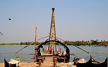
- Chinese fishing nets
- Fort Kochi Beach
- Dutch Cemetery
- Southern Naval Command Maritime Museum
- Cochin Thirumala Devaswom
- Sree Gopalakrishna Devaswom Temple (The Only Daivajna BrahminTemple in Kerala)
- Koonan Kurish Church, Mattancherry ( also known as Kuriachante Nada/ കുരിശിന്റെ നട / പ്രാന്തൻ കുരിയച്ഛന്റെ നട ) the church where Coonan Kurish Oath took place.
- St. Francis Church
- Santa Cruz Basilica
- Bishop's House
- Fort Emmanuel
- Jewish Synagogue
- Mattancherry Palace
- Jain Temple
- Our Lady of Hope Church
- Kochi-Muziris Biennale
- SREE JANARDHANA TEMPLE
References
- ^ "About Fort Cochin | Vasco House Fort Cochin | Homestay Fort Cochin | Heritage House". Archived from the original on 12 December 2019.
- ^ "THE MELTING POT OF CULTURES". Kimansion. Retrieved 25 June 2016.
- ^ "Here's where you should book a trip in 2020". Good Morning America.
- ^ The Portuguese, Indian Ocean and European Bridgeheads 1500–1800. Festschrift in Honour of Prof. K. S. Mathew (2001). Edited by: Pius Malekandathil and T. Jamal Mohammed. Fundacoa Oriente. Institute for Research in Social Sciences and Humanities of MESHAR (Kerala)
- ^ DC Books, Kottayam (2007), A. Sreedhara Menon, A Survey of Kerala History
- ^ "Diocese of Cochin". Academic Dictionaries and Encyclopedias. Retrieved 27 July 2022.
- ^ "Santa Cruz Cathedral Basilica Fort Kochi - History, Architecture". Trade Kerala. Retrieved 27 July 2022.
- ISBN 965-278-179-7.
- ^ "Cochin History". Cochin.org. Retrieved 25 June 2016.
- ^ "Fort Kochi". Travel India. Retrieved 25 June 2016.
- ^ "CHRONOLOGICAL LIST OF CENTRAL ACTS (Updated up to 17-10-2014)". Lawmin.nic.in. Retrieved 7 August 2016.
- ^ Lewis McIver, G. Stokes (1883). Imperial Census of 1881 Operations and Results in the Presidency of Madras ((Vol II) ed.). Madras: E.Keys at the Government Press. p. 444. Retrieved 5 December 2020.
- ^ Presidency, Madras (India (1915). Madras District Gazetteers, Statistical Appendix For Malabar District (Vol.2 ed.). Madras: The Superintendent, Government Press. p. 20. Retrieved 2 December 2020.
- ^ HENRY FROWDE, M.A., Imperial Gazetteer of India (1908–1909). Imperial Gazetteer of India (New ed.). Oxford: Clarendon Press. Retrieved 2 December 2020.
External links
- A short YouTube video visualizing areas to be visited in and around Fort Kochi
- The Great Fire of Cochin 1889 - Article by The Hindu
- Fort Kochi, Its History and Culture - Josbin Itty
This article needs additional citations for verification. (January 2017) |
