
Fort Mercer
| Fort Mercer | |
|---|---|
Earthwork | |
| Site history | |
| Built | 1777 |
| Built by |
|
| In use | 1777–1781 |
| Materials | earth, logs |
Red Bank Battlefield | |
| Location | 100 Hessian Ave., National Park, NJ 08063 |
| NRHP reference No. | 72000796[1] |
| NJRHP No. | 1405[2] |
| Significant dates | |
| Added to NRHP | October 31, 1972[1] |
| Designated NHL | November 28, 1972[3] |
| Designated NJRHP | August 16, 1979 |
| Battles/wars | American Revolutionary War |
| Garrison information | |
| Past commanders | Christopher Greene |
Fort Mercer was an earthen fort on the eastern shores of the
Fort Mercer was located in an area called Red Bank in what is now the borough of
The fort's site is now part of Red Bank Battlefield Historical Park, which includes a monument and museum. Several cannons attributed to British warships lost supporting the attack on the fort, and others found buried at the fort itself, are in the park.[4]
Background


Fort Mercer was built and
The fort could accommodate a garrison of 1,500 men, but only 600 were available, mostly Rhode Island troops of the Continental Army commanded by Colonel Christopher Greene, also a Rhode Islander. French officer Thomas Duplessis made the fort more defensible by the small garrison by having a wall built inside the river side of the fort.[5]
On October 22, 1777, in the
Fort Mifflin and the Pennsylvania Navy engaged the stranded ships the next morning, with cannons and fire rafts, respectively. HMS Augusta of 64 guns caught fire and within an hour the fire reached the magazine and the ship exploded, though the loss was attributed to accidental ignition by the British. One account states a British Marine accidentally fired his musket into a hammock, with the fire resulting from subsequent smoldering. HMS Merlin was also lost. After the later loss of Fort Mifflin, Fort Mercer was abandoned when Lord Charles Cornwallis landed 2,000 British troops nearby on November 18, 1777.
As British artillery breached the walls, the defenders of Fort Mercer blew up their magazine before abandoning the fort.[6][7][8]
The British abandoned Fort Mercer as they evacuated Philadelphia on June 18, 1778. The Patriots retook the site and rebuilt the fort, manning it until 1781, when the fighting moved to Yorktown, Virginia, culminating in an American victory and leading to the cessation of hostilities.[9][5]
Gallery
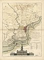
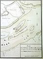
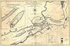
- During the Philadelphia Campaign, the British had several maps drafted of the Delaware River, Fort's Mifflin, and Fort Mercer, as they attempted to seize the revolutionary capital of Philadelphia.
-
-

-

-
-


See also
- Fort Billingsport
- Fort Mifflin
- List of coastal fortifications of the United States
- National Register of Historic Places listings in Gloucester County, New Jersey
- Seacoast defense in the United States
References
- ^ a b "National Register Information System". National Register of Historic Places. National Park Service. July 9, 2010.
- ^ "New Jersey and National Registers of Historic Places - Gloucester County" (PDF). New Jersey Department of Environmental Protection - Historic Preservation Office. April 1, 2010. p. 6. Archived from the original (PDF) on August 18, 2011. Retrieved September 28, 2010.
- ^ "Red Bank Battlefield". National Historic Landmark summary listing. National Park Service. June 23, 2008. Archived from the original on February 25, 2009.
- ^ a b "Fort Mercer". RevolutionaryWarNewJersey.com.
- ^ a b "Fort Mercer". FortWiki.com.
- ^ "Survey of Historic Sites and Buildings". National Park Service. Retrieved September 24, 2007.
- ISBN 0-02-926880-X.
- ^ "The story of the battle of Red Bank". friendsofredbank. Retrieved December 12, 2018.
- ^ "Fort Mercer". American Forts Network.
External links
- "Forts and Fortifications" at PhiladelphiaEncyclopedia.org