
Fort Pierce Inlet State Park
| Fort Pierce Inlet State Park | |
|---|---|
North Hutchinson Island, St. Lucie County, Florida, USA | |
| Nearest city | Fort Pierce, Florida |
| Coordinates | 27°28′59″N 80°18′22″W / 27.48306°N 80.30611°W |
| Area | 340 acres (1.4 km2) |
| Governing body | Florida Department of Environmental Protection |
Fort Pierce Inlet State Park, a 340-acre (1.4 km2) part of the
North Hutchinson Island, near Fort Pierce. It consists of beaches, dunes and a coastal hammock between the Atlantic Ocean and the waters of Tucker Cove, an indentation of the Indian River Lagoon.[1]
Recreational Activities
The primary use of the park is as a recreation area. Activities include
nature trail
, and a reef about 100 yards (91 m) from the beach.
Jack Island State Preserve
Jack Island State Preserve, located a mile north of Fort Pierce Inlet State Park on State Road A1A is under the same management as the state park. Jack Island features trails for hiking, biking, and studying nature. At the west end of its Marsh Rabbit Run Trail, there is an observation tower with views of the Indian River and of Jack Island itself.
Gallery
-
 Path leading to the beach
 -
 Picnic area
 -
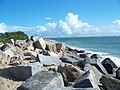 Jetty at the inlet


References
- ^ Map of Fort Pierce, etc, 1998, Fort Lauderdale: Dolph Map Co.
External links
![]() Media related to Fort Pierce Inlet State Park at Wikimedia Commons
Media related to Fort Pierce Inlet State Park at Wikimedia Commons
- Fort Pierce Inlet State Park at Florida State Parks
- Fort Pierce Inlet State Park at Wildernet
- Fort Pierce Inlet State Park at Absolutely Florida