
Fort Santiago
| Fort Santiago | |
|---|---|
Moóg ng Santiago | |
 The reconstructed main gate of Fort Santiago | |
 .svg) .svg) | |
| General information | |
| Type | Bastioned fort |
| Architectural style | Italian-Spanish school of fortification |
| Location | along the Pasig River |
| Town or city | Intramuros |
| Country | Philippines |
| Coordinates | 14°35′42″N 120°58′10″E / 14.59500°N 120.96944°E |
| Named for | Saint James the Great |
| Construction started | 1590 |
| Completed | 1593 |
| Renovated | 1733 |
| Dimensions | |
| Other dimensions | 2,030 feet (620 m) perimeter |
| Technical details | |
| Structural system | Masonry |
| Design and construction | |
| Architect(s) | Gómez Pérez Dasmariñas (1590) Fernándo Valdés y Tamon (1730s) |
| Structural engineer | Leonardo Iturriano[1] |
| Designations | National Historical Landmark |
| Website | |
| visitfortsantiago | |
Fort Santiago (Spanish: Fuerte de Santiago; Filipino: Kutà ng Santiago), built in 1571, is a citadel built by Spanish navigator and governor Miguel López de Legazpi for the newly established city of Manila in the Philippines. The defense fortress is located in Intramuros, the walled city of Manila.
The fort is one of the most important historical sites in Manila. Several people died in its prisons during the Spanish Empire and World War II. José Rizal, the Philippine national hero, was imprisoned here before his execution in 1896. The Rizal Shrine museum displays memorabilia of the hero in their collection and the fort features, embedded onto the ground in bronze, his footsteps representing his final walk from his cell to the location of the actual execution.
It is only a few meters away from the Manila Cathedral and the Palacio del Gobernador (lit. Governor's Palace, currently the office of the Commission on Elections).
Profile

_Pillars_of_Hercules_Variant.svg)
The fort was named after
]The fort has a
The 22-foot (6.7 m) high walls, with a thickness of 8 feet (2.4 m) are pierced for the necessary communications. The front gateway façade measures 40 feet (12 m) high being in the south wall and facing the city. The communication with the river and the sea was by an obscure postern gate - the Postigo de la Nuestra Señora del Soledad (Postern of Our Lady of Solitude). Inside the fort were guard stations, together with the barracks of the troops of the garrison and quarters of the warden and his subalterns. Also inside the fort were various storehouses, a chapel, the powder magazine, the sentry towers, the cisterns, etc.[4]
History

The location of Fort Santiago was once the site of a
The first fort was a structure of palm logs and earth. Most of it was destroyed when the city was invaded by Chinese pirates led by Limahong. Martin de Goiti was killed during the siege. After a fierce conflict, the Spaniards under the leadership of Juan de Salcedo, eventually drove the pirates out to Pangasinan province to the north, and eventually out of the country.[6]: 32–44
The construction of Fort Santiago with hard stone, together with the original fortified walls of Intramuros, commenced in 1590 and finished in 1593 during the term of Governor-General
During the leadership of Fernándo Valdés y Tamon in the 1730s, a large semicircular gun platform to the front called media naranja (half orange) and another of lesser dimensions to the river flank were added to the Bastion of Santa Barbara. The casemates were then filled in and embrasures closed. He also changed the curtain wall facing cityward to a bastioned front. A lower parapet, bordering the interior moat, connects the two bastions.[8]
British occupation
On September 24, 1762, British forces led by Brigadier-General William Draper and Rear-Admiral Samuel Cornish invaded and captured Manila, and along with it Fort Santiago. It was during this time that the fort served as a base of operations for the Royal Navy until April 1764 when they agreed to a ceasefire with the Spanish.[11]

American colonial period

On August 13, 1898, the American flag was raised in Fort Santiago signifying the start of the
World War II
During
The fort today
Today, the fort, its bastions, and the prison dungeons for criminals used by the Spanish officials, is now part of a historical park which also includes
Adaptive use of this famous historical landmark makes certain areas ideal for open air theater, picnics, and as a
Preservation
After its destruction during WWII, Fort Santiago was declared as a Shrine of Freedom in 1950. Its restoration by the Philippine government did not begin till 1953 under the hands of the National Parks Development Committee. The Intramuros Administration now manages the reconstruction, maintenance, and management of the fort since 1992.[13]
Gallery
-
 Fort Santiago in 1913
 -
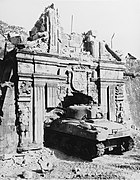 A U.S. Army M4 Sherman enters the fort during the Battle of Manila, 1945
 -
 Fort Santiago gate before its reconstruction and restoration
 -
 Fort Santiago gate after restoration
 -
 The entrance of Fort Santiago
 -
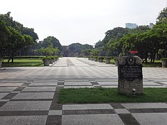
 The grounds of Fort Santiago with the Binondo skyline in the background
 -
 Fort Santiago in 2020
_(14753394646).jpg)


.jpg)
See also
- Fort of San Antonio Abad
References
- ^ Robb, Walter (1939). Filipinos. Manila: Carmelo & Bauermann. pp. 210–215.
- ^ John T. Pilot (October 22, 2009). "Fort Santiago Gate". Flickr. Retrieved on January 8, 2012.
- ^ John T. Pilot (October 22, 2009). "Fort Santiago Gate". Flickr. Retrieved on January 8, 2012.
- ^ a b Congressional Serial Set. U.S. Government Printing Office. 1903. p. 437.
 This article incorporates text from this source, which is in the public domain.
- ^ Congressional Serial Set. U.S. Government Printing Office. 1903. p. 435. This article incorporates text from this source, which is in the public domain.
- OCLC 769945703.
Explorations by early navigators, descriptions of the islands and their peoples, their history and records of the catholic missions, as related in contemporaneous books and manuscripts, showing the political, economic, commercial and religious conditions of those islands from their earliest relations with European nations to the beginning of the nineteenth century.
- ^ "Fort Santiago Marker". Wikimedia Commons. Retrieved on January 7, 2012.
- ^ a b Congressional Serial Set. U.S. Government Printing Office. 1903. p. 436. This article incorporates text from this source, which is in the public domain.
- ^ tzquita (2008-007-11). "At the gate of Fort Santiago". Flickr. Retrieved on January 17, 2012.
- ^ https://academic.oup.com/past/article/232/1/87/1752419 Convicts or Conquistadores? Spanish Soldiers in the Seventeenth-Century Pacific By Stephanie J. Mawson] AGI, México, leg. 25, núm. 62; AGI, Filipinas, leg. 8, ramo 3, núm. 50; leg. 10, ramo 1, núm. 6; leg. 22, ramo 1, núm. 1, fos. 408 r –428 v; núm. 21; leg. 32, núm. 30; leg. 285, núm. 1, fos. 30 r –41 v .
- ^ Robertson, J.A., and E.H. Blair. The Philippine Islands 1493-1898. Vol. Volume 4. Jeroen Hellingman and the Distributed Proofreaders Team, 2004. Print.
- ^ "Fort Santiago, Intramuros, Manila, Philippines". Flickr. Retrieved on January 9, 2012. One of the inmates who survived the torture and the War was Roy Anthony Cutaran Bennett.
- ^ tzquita (2008-007-11). "At the gate of Fort Santiago". Flickr. Retrieved on January 7, 2012.
- U.S. War Department (1903). "Annual Report of the War Department, 1903 Vol. III". Government Printing Office, Washington.
External links
 Media related to Fort Santiago (Manila) at Wikimedia Commons
- The gate of Fort Santiago in the 1920s from Flickr
Historic District of Manila | ||
| Buildings |  | |
| Fortifications | ||
| Parks, open spaces, and monuments | ||
| Museums | ||
| Education | ||
| Government | ||
| Destroyed | ||
| Administrators | ||
| Historical sites | | |
|---|---|---|
| Religious buildings |
| |
| Museums and galleries |
| |
| Integrated resorts | ||
| Amusement |
| |
| Parks and gardens | ||
| Shopping | ||
| Events and traditions | ||
| Event venues | ||
| By type | ||
| Government cultural agencies | ||
|---|---|---|
| Categories of cultural properties | ||
| Related | ||
| International | |
|---|---|
| National | |