
Ahmednagar Fort
| Ahmednagar fort | |
|---|---|
| Ahmednagar, Maharashtra | |
 | |
 Ahmednagar fort  Ahmednagar fort | |
| Coordinates | 19°05′41.3″N 74°45′19.7″E / 19.094806°N 74.755472°E |
| Type | Land fort |
| Site information | |
| Owner | Indian Military |
| Controlled by | Ahmadnagar Sultanate (1562-1600)
Sardar Patel |
The Ahmednagar Fort (Ahmadnagar Qilaa) is a fort located close to the Bhingar Nala near
Major features
In 1803, the Ahmednagar Fort was round in appearance, with twenty-four bastions, one large gate, and three small sally ports. It had a
A gunshot to the west of the fort was the Pettah of Ahmednagar. The main gate of the fort faced the pettah, and was defended by a small half-circular work, with one traverse and several little towers for men. There was a wooden bridge over the ditch, which could be taken away in time of war, but it was not a drawbridge. It was reported that an iron trough as large as the bridge, could be placed upon it, or on the supporters of it, and fill with charcoal or other combustibles, to which could be ignited as an enemy approached.[2] The fort is also called as Bhuikot Killa which means it is a land fort and is not constructed on any hill.[3] It should not be confused with other Bhuikot Killas in Maharashtra like Solapur Bhuikot Killa.
A small river came from the northward, round the west side of the pettah, and passed to the southward of the fort. A nullah also passed from the northward, between the fort and a town called Bhingar, about a gunshot to the eastward, and joined the river. A potential defensive weakness was a little hill or rising ground close to and east of Bhingar, from which shot from siege guns could reach the fort.[2]
Two nills or covered aqueducts came from the hills, a mile or more to the north, passed through and supplied the pettah and the town, and then went into the fort, either under or through the ditch, into which the wastewater fell.[2]
There were no passages across the ditch from the sally ports, and no part of the aqueducts appeared above the ditch. The nullah mentioned above had steep banks and passed within 60 yards of the fort; the aqueduct from Bhingar passed under it. There was no bridge or even a prominent crossing point at the nullah and hence no clearly defined route between the fort and the town of Bhingar.[2]
There were many small pagodas and mosques around the pettah and the fort, but none exactly between, or between the fort and Bhingar, or nearer to the fort than those towns.[2]
History
_pg339_AHMEDNUGGUR_-_DUMREE_MUSJID.jpg)
The fort was built by
In 1803, during the Second Anglo-Maratha War, Arthur Wellesley defeated the Maratha forces and the East India Company came into possession of the fort.[citation needed]
Modern era
The fort was known as Ahmednagar Fort and was used by the
During the same time, Odisha's first Chief-Minister and ex-Governor of undivided Bombay State, Harekrushna Mahatab also compiled three volumes of the History of Odisha in Odia. This has later been translated and published in English and Hindi.[citation needed]
Currently, the fort is under the administration of the Armoured Corps of the Indian Army.[11]
Gallery
-
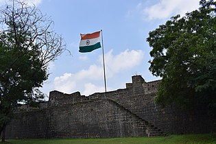 Ahmednagar Fort with the national flag
 -
 Ahmednagar Fort ramparts
 -
 Ahmednagar Fort interior
 -
 Inside view of Ahmednagar Fort's gate
 -
 Part of the moat around Ahmednagar Fort
 -
 Jawaharlal Nehru's room during his incarceration (1942–1945)


See also
References
- ^ In some older references Fort of Ahmednuggur
- ^ a b c d e f
 This article incorporates text from this source, which is in the public domain: Wellesley (Duke of Wellington), Arthur Richard (1859). "Memorandum of the Ahmednuggur Fort". In J. Murray (ed.). Supplementary despatches and memoranda of field marshal Arthur duke of Wellington 1797-1819 with a map of India. p. 100.
- ^ "Ahmednagar Fort (Bhuikot Fort) - Total Safari".
- ^ a b Gazetteer of the Bombay Presidency. Govt Central Press. 1896. p. 238. Retrieved 10 March 2009.
- ^ a b Cowley, Capt Cecil (1919). "IX". Tales of Ahmednagar. Bombay: Thacker and Company Ltd.
- ^ a b "Ahmednagar fort". Maharashtra Tourism Development Corporation. Retrieved 10 March 2009.
- ISBN 978-9-38060-734-4.
- OCLC 633709290.
- ^ Gazetteer of the Bombay Presidency. Govt. Central Press. 1884. p. 409. Retrieved 10 March 2009.
- ISBN 978-0-691-05732-3. Retrieved 10 March 2009.
- ^ a b c Gill, Himmat Singh (3 September 2006). "Where freedom held fort". The Sunday Tribune. Retrieved 10 March 2009.
- ^ "Tribute in the thick of toil". The Telegraph-Calcutta. 15 August 2004. Archived from the original on 4 February 2013. Retrieved 10 March 2009.