
Jones County, Mississippi
Jones County | |
|---|---|
 Jones County courthouse in Ellisville | |
|
UTC−5 (CDT) | |
| Congressional districts | 3rd, 4th |
| Website | jonescounty |
Jones County is in the southeastern portion of the
Jones County is part of the Laurel micropolitan area.
History
Less than a decade after Mississippi became the country's 20th state, settlers organized this area of 700 sq mi (1,800 km2) of pine forests and swamps for a new county in 1826. They named it Jones County after John Paul Jones, the early American Naval hero who rose from humble Scottish origin to military success during the American Revolution.[3]
Jones County was in an area of mostly yeomen farmers and lumbermen, as the pine forests, swamp and soil were not easily cultivated for cotton. In 1860, the majority of white residents were not slaveholders. Slaves made up only 12% of the total population in Jones County in 1860, the smallest percentage of any county in the state.[4]
Civil War years
Soon after the election of Abraham Lincoln as United States president in November 1860, slave-owning planters led Mississippi to join South Carolina and secede from the Union. These were the two states with the largest holdings of slaves. On November 29, 1860, the Mississippi state legislature called for a "Convention of the people of Mississippi" to be held to "adopt such measures for vindicating the sovereignty of the State as shall appear to them to be demanded."[5] The Convention convened on January 7, 1861, and the elected representatives from the various counties of Mississippi voted 83–15 to secede from the Union. Notably, included in the vote to secede was the representative from Jones County, Mr. John H. Powell. Other Southern states would follow suit.
As Mississippi debated the secession question, the inhabitants of Jones County voted overwhelmingly for the anti-secessionist John Hathorne Powell, Jr. In comparison to the pro-secessionist J.M. Bayliss, who received 24 votes, Powell received 374.[6] But, at the Secession Convention, Powell voted for secession. Legend has it that, for his vote, he was burned in effigy in Ellisville, the county seat.[6]
The reality is more complicated. The only choices possible at the Secession Convention were voting for immediate secession on the one hand, or for a more cautious, co-operative approach to secession among several Southern states on the other. Powell almost certainly voted for the more conservative approach to secession—the only position available to him that was consistent with the anti-secessionist views of his constituency.[6]
Mississippi's Declaration of Secession reflected planters' interests in its first sentence: "Our position is thoroughly identified with the institution of slavery…" Jones County had mostly yeoman farmers and cattle herders, who were not slaveholders and had little use for a war over slavery.
During the
Free State of Jones
On October 13, 1863, a band of deserters from Jones County and adjacent counties organized to protect the area from Confederate authorities and the crippling tax collections.[8] The company, led by Newton Knight, formed a separate government, with Unionist leanings, known as the "Free State of Jones",[9] and fought a recorded 14 skirmishes with Confederate forces. They also raided Paulding, capturing five wagonloads of corn that had been collected for tax from area farms, which they distributed back among the local population.[10] The company harassed Confederate officials. Deaths believed to be at their hands were reported in 1864 among numerous tax collectors, conscript officers, and other officials.[4]
The governor was informed by the Jones County court clerk that deserters had made tax collections in the county impossible.
Scholars have disputed whether the county truly seceded, with some concluding it did not fully secede. While there have been numerous attempts to study Knight and his followers, the lack of documentation during and after the war has made him an elusive figure. The rebellion in Jones County has been variously characterized as consisting of local skirmishes to being a full-fledged war of independence. It assumed legendary status among some county residents and Civil War historians, culminating in the release of a 2016 feature film, Free State of Jones.[13][14][15] The film is credited as "based on the books 'The Free State of Jones' by Victoria E. Bynum and 'The State of Jones' by Sally Jenkins and John Stauffer."[14]
The county changed its name to Davis County, after Confederate president Jefferson Davis, on November 30, 1865, and kept the name until four years later.[16]
Geography
According to the
Adjacent counties
- Jasper County (north)
- Wayne County (east)
- Perry County (southeast)
- Forrest County (southwest)
- Covington County (west)
- Smith County (northwest)
National protected area
- De Soto National Forest (part)
Demographics
| Census | Pop. | Note | %± |
|---|---|---|---|
| 1830 | 1,471 | — | |
| 1840 | 1,258 | −14.5% | |
| 1850 | 2,164 | 72.0% | |
| 1860 | 3,323 | 53.6% | |
| 1870 | 3,313 | −0.3% | |
| 1880 | 3,828 | 15.5% | |
| 1890 | 8,333 | 117.7% | |
| 1900 | 17,846 | 114.2% | |
| 1910 | 29,885 | 67.5% | |
| 1920 | 32,919 | 10.2% | |
| 1930 | 41,492 | 26.0% | |
| 1940 | 49,227 | 18.6% | |
| 1950 | 57,235 | 16.3% | |
| 1960 | 59,542 | 4.0% | |
| 1970 | 56,357 | −5.3% | |
| 1980 | 61,912 | 9.9% | |
| 1990 | 62,031 | 0.2% | |
| 2000 | 64,958 | 4.7% | |
| 2010 | 67,761 | 4.3% | |
| 2020 | 67,246 | −0.8% | |
| 2023 (est.) | 66,250 | [18] | −1.5% |
| U.S. Decennial Census[19] 1790-1960[20] 1900–1990[21] 1990-2000[22] 2010–2013[1] | |||
| Race | Num. | Perc. |
|---|---|---|
White (non-Hispanic)
|
41,676 | 61.98% |
Black or African American (non-Hispanic)
|
19,135 | 28.46% |
Native American
|
364 | 0.54% |
Asian
|
272 | 0.4% |
Pacific Islander
|
24 | 0.04% |
Other/Mixed
|
1,636 | 2.43% |
Latino
|
4,139 | 6.16% |
As of the 2020 United States census, there were 67,246 people, 24,178 households, and 16,729 families residing in the county.
Economy
The economy of Jones County is still primarily rural and based on resources – timber and agriculture.
According to the Economic Development Authority of Jones County, the top employers in the county are:[24]
| # | Employer | Employees |
|---|---|---|
| 1 | Howard Industries | 3,700 |
| 2 | South Central Regional Medical Center | 1,837 |
| 3 | Ellisville State School | 1,459 |
| 4 | Jones County School District | 1,162 |
| 5 | Sanderson Farms | 889 |
| 6 | Wayne Farms | 715 |
| 7 | Laurel School District | 600 |
| 8 | Walmart | 585 |
| 9 | Masonite | 556 |
| 10 | Jones County | 510 |
| 11 | Sawmill Square Mall | 450 |
| 12 | Jones County Junior College
|
427 |
| 13 | MS Industries for Individuals with Disabilities | 415 |
| 14 | Southern Hens | 390 |
| 15 | City of Laurel | 317 |
| 16 | Tanner Construction | 185 |
| 17 | Hudson's Salvage Center | 153 |
| 18 | Dunn Roadbuilders | 145 |
| 19 | Morgan Brothers Millwork | 137 |
| 20 | West Quality Food Service | 135 |
Government and infrastructure
The Mississippi Department of Mental Health South Mississippi State Hospital Crisis Intervention Center is in Laurel and in Jones County.[25]
Transportation
Major highways
- Interstate 59
 U.S. Highway 11
- U.S. Highway 84
 Mississippi Highway 15
 Mississippi Highway 28
 Mississippi Highway 29
Airport
Politics
| Year | Republican | Democratic | Third party | |||
|---|---|---|---|---|---|---|
| No. | % | No. | % | No. | % | |
| 2020 | 21,226 | 70.54% | 8,517 | 28.30% | 348 | 1.16% |
| 2016 | 20,133 | 71.01% | 7,791 | 27.48% | 428 | 1.51% |
| 2012 | 20,687 | 68.59% | 9,211 | 30.54% | 261 | 0.87% |
| 2008 | 20,157 | 68.86% | 8,846 | 30.22% | 270 | 0.92% |
| 2004 | 19,125 | 71.72% | 7,398 | 27.74% | 143 | 0.54% |
| 2000 | 16,341 | 67.14% | 7,713 | 31.69% | 286 | 1.18% |
| 1996 | 13,020 | 59.62% | 7,360 | 33.70% | 1,457 | 6.67% |
| 1992 | 13,824 | 56.59% | 8,035 | 32.89% | 2,571 | 10.52% |
| 1988 | 16,764 | 69.07% | 7,383 | 30.42% | 125 | 0.51% |
| 1984 | 17,586 | 70.47% | 7,298 | 29.25% | 70 | 0.28% |
| 1980 | 12,900 | 53.11% | 11,117 | 45.77% | 272 | 1.12% |
| 1976 | 11,098 | 51.49% | 10,139 | 47.04% | 315 | 1.46% |
| 1972 | 16,489 | 83.79% | 2,790 | 14.18% | 400 | 2.03% |
| 1968 | 3,242 | 18.02% | 2,476 | 13.76% | 12,276 | 68.22% |
| 1964 | 12,123 | 85.95% | 1,981 | 14.05% | 0 | 0.00% |
| 1960 | 2,729 | 25.92% | 4,871 | 46.27% | 2,928 | 27.81% |
| 1956 | 2,463 | 29.81% | 5,137 | 62.17% | 663 | 8.02% |
| 1952 | 4,039 | 40.70% | 5,884 | 59.30% | 0 | 0.00% |
| 1948 | 193 | 2.96% | 599 | 9.18% | 5,736 | 87.87% |
| 1944 | 337 | 6.58% | 4,782 | 93.42% | 0 | 0.00% |
| 1940 | 242 | 5.09% | 4,517 | 94.91% | 0 | 0.00% |
| 1936 | 185 | 3.94% | 4,461 | 95.02% | 49 | 1.04% |
| 1932 | 173 | 4.15% | 3,816 | 91.47% | 183 | 4.39% |
| 1928 | 1,804 | 44.13% | 2,284 | 55.87% | 0 | 0.00% |
| 1924 | 318 | 10.08% | 2,373 | 75.21% | 464 | 14.71% |
| 1920 | 419 | 30.08% | 734 | 52.69% | 240 | 17.23% |
| 1916 | 196 | 9.42% | 1,664 | 80.00% | 220 | 10.58% |
| 1912 | 34 | 2.37% | 1,058 | 73.88% | 340 | 23.74% |
Communities
Cities
Towns
Census-designated place
Unincorporated communities
Notable people
- Lance Bass, singer with NSYNC
- Ralph Boston, Olympic track and field medalist
- Jason Campbell, retired National Football League quarterback
- Mary Elizabeth Ellis-Day, actress
- Carroll Gartin, lieutenant governor of Mississippi
- US Marshaland a leading Republican figure in the Reconstruction of Mississippi
- Ira Clinton Welborn, Medal of Honor recipient in the Spanish–American War
- Jill Collen Jefferson, human rights lawyer
- Tom Lester, actor played Eb on Green Acres
- Amos McLemore, schoolteacher, Methodist pastor, businessman, and one-time opponent of Southern secession from the Union; commissioned as a Confederate officer at the rank of major; he was reputedly assassinated by Newton Knight
- Charles W. Pickering, retired Federal Circuit Judge who served on the United States Court of Appeals for the Fifth Circuit
- Parker Posey, actress
- Leontyne Price, operatic soprano
- James Street, author
- Ray Walston, actor My Favorite Martian
See also
References
- ^ a b "United States Census Bureau". United States Census Bureau. Retrieved December 12, 2021.
- ^ "Find a County". National Association of Counties. Archived from the original on May 31, 2011. Retrieved June 7, 2011.
- ^ "Jones County MS".
- ^ a b c d e f Kelly, James R. Jr. (April 2009). "Newton Knight and the Legend of the Free State of Jones". mshistorynow.mdah.ms.gov. Mississippi History Now. Mississippi Historical Society. Archived from the original on December 23, 2016. Retrieved February 3, 2019.
- ^ Power, J. L. (1861). Proceedings of the Mississippi State Convention, Held January 7th to 26th, A. D. 1861. Jackson, Miss.: Power and Cadwallader. p. 5. Retrieved June 8, 2022.
- ^ a b c Leverett, Rudy H., Legend of the Free State of Jones, University Press of Mississippi, 1984, pp. 38–41.
- Project MUSE book 28770.[page needed]
- ISBN 978-0-385-53032-3.
- ^ Evan Andrews (January 13, 2015). "6 Southern Unionist Strongholds During the Civil War". History Channel. Retrieved April 5, 2017.
- ^ Leverett (1984), Legend of the Free State of Jones, p. 64.
- ^ Leverett (1984), Legend of the Free State of Jones, p. 112
- ^ Leverett (1984), Legend of the Free State of Jones, pp. 17–29
- ^ Richard Grant, The True Story of the ‘Free State of Jones’, Smithsonian Magazine, March 2016
- ^ a b State of Jones (2016)[permanent dead link], History vs Hollywood (retrieved 26 August 2016)
- ^ Mick LaSalle, "Movies to look for (maybe) in 2016". San Francisco Chronicle, December 30, 2015.
- ^ "MS: Individual County Chronologies".
- ^ "2010 Census Gazetteer Files". United States Census Bureau. August 22, 2012. Archived from the original on September 28, 2013. Retrieved November 4, 2014.
- ^ "Annual Estimates of the Resident Population for Counties: April 1, 2020 to July 1, 2023". United States Census Bureau. Retrieved April 5, 2024.
- ^ "U.S. Decennial Census". United States Census Bureau. Retrieved November 4, 2014.
- ^ "Historical Census Browser". University of Virginia Library. Retrieved November 4, 2014.
- ^ "Population of Counties by Decennial Census: 1900 to 1990". United States Census Bureau. Retrieved November 4, 2014.
- ^ "Census 2000 PHC-T-4. Ranking Tables for Counties: 1990 and 2000" (PDF). United States Census Bureau. Archived (PDF) from the original on March 27, 2010. Retrieved November 4, 2014.
- ^ "Explore Census Data". data.census.gov. Retrieved December 16, 2021.
- ^ "Major Employers". Archived from the original on September 4, 2015. Retrieved September 15, 2013.
- ^ "Contact Us Archived 2012-03-14 at the Wayback Machine." South Mississippi State Hospital. Retrieved on November 1, 2010. "SMSH Crisis Intervention Center 934 West Drive Laurel, MS 39440."
- Hattiesburg-Laurel Regional Airport. Retrieved on July 15, 2011. "Our Address Airport Director, 1002 Terminal Dr. Moselle, MS 39459"
- U.S. Census Bureau. Retrieved on July 16, 2011.
- ^ Leip, David. "Dave Leip's Atlas of U.S. Presidential Elections". uselectionatlas.org. Retrieved March 3, 2018.
Further reading
- Ballard, Michael B. and Mark R. Cheathem, Of Times and Race: Essays Inspired by John F. Marszalek, Oxford, MS: University Press of Mississippi, 2013
- Bynum, Victoria E. (2002). The Free State of Jones: Mississippi's Longest Civil War. The University of North Carolina Press.
- Downing, David C. (2007). A South Divided: Portraits of Dissent in the Confederacy. Nashville: Cumberland House. ISBN 978-1-58182-587-9.
- Galloway, G. Norton., Historian Sixth Army Corps. (November 1886). "A Confederacy within a Confederacy," Magazine of American History 16.
- Jenkins, Sally, and John Stauffer (2009). The State of Jones: The Small Southern County that Seceded from the Confederacy, New York: Random House. ISBN 978-0-385-52593-0.
- Leverett, Rudy H. (1984, second printing 2009). Legend of the Free State of Jones. University Press of Mississippi. ISBN 978-0-87805-227-1.
- McLemore, Richard Aubrey. (1973) History of Mississippi (2 volumes), University & College Press of Mississippi.
External links
- Jones County Courthouse Pictures
- Jones County Sheriff's Office
 Media related to Jones County, Mississippi at Wikimedia Commons
Places adjacent to Jones County, Mississippi | ||||||||||||||||
|---|---|---|---|---|---|---|---|---|---|---|---|---|---|---|---|---|
| ||||||||||||||||
Municipalities and communities of Jones County, Mississippi, United States | ||
|---|---|---|
| Cities | 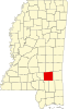 | |
| Towns | ||
| CDPs | ||
| Other communities | ||
| Indian reservation | ||
| Footnotes | ‡This populated place also has portions in an adjacent county or counties | |
| ||
| International | |
|---|---|
| National | |
| Other | |