
Freeport of Copenhagen

The Free Port of Copenhagen is a
History
Planning and construction

In the middle of the 19th century, Copenhagen's growth and the increasing
Management and use
The new free port was inaugurated on 9 November 1894. A private limited company, Københavns Frihavns-Aktieselskab (KFA), was given a concession on operating the port by the Ministry of Interior Affairs. All shares in the Free Port Company was taken over by Port Authority in 1951 and the company was dissolved and replaced by Københavns Frihavns- og Stevedoreselskab A/S in 1879.
Expansions
In 1915–15, the free port was expanded with a new basin, Jronløn Basin (Danish: Kronløbsbasinet), located to the north. It blocked the access to the Kalkbrænderihavnen dock, making it necessary to dig out a new access canal to it. The next expansion of the free port took place between 1919 and 1931, creating the harbour basin now known as Orient Basin.
Late history
The free port left its original grounds in 1885. An architectural competition was launched for the future use of the area. Among the entries were a proposal from Jørn Utzon which included a highrise and several other buildings on Langelinie Pier but none of the submissions were realized. The Amerika Plads area was redeveloped in the 2000s.
The free port is now located in
Layout and key figures

The original free port was designed by Holger Christian Valdemar Møller, who later served as managing director of the Free Port Company, based on an initial proposal drafted by the politician and engineer Holger Hammerich. It consists of a West Quay (now America Quay, a South Quay (now India Quay and an East Pier (now Langelinie), together forming an enclosed dock which was entered from the north. A shorter pier, Midtermolen (Rnglish: Middle Pier), extended north from South Quay, separating the harbour into an east and a west basin. Only the west side of East Pier was part of the free port. The east side of the pier was used for recreational purposes as a replacement of the promenade which had previously followed the coastline. The two sides were separated from each other by the Langelinie Promenade, a raised promenade constructed on top of a long row of low warehouses. The dock is to the north closed by the Marble Pier, leaving only a narrow entrance in the north-east.
In 1931, after the second expansion had been completed, the free port covered a total area of 82.5 hectares of which 49.1 hectares were land and 33.4 hectares were water. The total length of the quays was approximately 4,770 metres with water depth between 7.5 m to 9.5 m.
Buildings and features

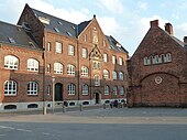
Custom Guard Building
The Custom Guard Building (Danish: Toldvagten) was built in 1894 to designs by Erik Schiødt. It was expanded in 1918 by J.C.M. Agerskov and again in 1932 with a three storey extension designed by John Dich. The complex was listed in 1988.[2]
Central Power Station
The Central Power Station (Danish:Frihavnens Elektriske Centralstation) was built in 1894-95 to designs by Vilhelm Dahlerup. A boilerhouse with a detached chimney designed by Frederik L. Levy was added in 1899. A workshop building designed by Henning Jørgensen is from 1913.[3]
Dahlerup's warehouses
Dahlerup also designed many other buildings in the original free port, including warehouses, guardhouses, quays and the fence which surrounded the area. Warehouse I on
Manufaktorhuset
Manufakturhuset at 8-10 Dampfærgevej was designed by Frederik L. Levy, and built in 1899. The architectural firm
Silo Warehouse
The Silo Warehouse was completed in 1903 to designs by Frederik L. Levy. It was listed in 1985.[4] It is colloquially known as the Cathedral of the Free Port due to its twin towers.[5] Adapted and expanded by Erik Møller Architects in 1993, it now houses Danish Regions.[6]
-
 The Central Power Station
 -
 Dahlerup Warehouse at Langelinie Pier
 -
 The former Head Office
 -
 The Silo Warehouse


References
- ^ "Badestranden ved Langelinie". Berlingske Tidende. Retrieved 2009-04-09.
- ^ "Sag: Toldvagten". Kulturstyrelsen. Retrieved 2012-12-06.
- ^ "Sag: Frihavnens Elektriske Centralstation (tidl.)" (in Danish). Kulturstyrelsen. Retrieved 2012-12-06.
- ^ "Sag: Silopakhuset" (in Danish). Kulturstyrelsen. Retrieved 2012-12-06.
- ^ ""Domkirken" i Frihavnen" (in Danish). Skov- og Naturstyrelsen. Retrieved 2011-12-12.
- ^ "Historiske bygninger på Amerika Plads" (in Danish). By & Havn. Retrieved 2011-12-12.