
Frescati (Stockholm)

Frescati is a park-like area on the northern outskirts of Stockholm, Sweden. It is situated in an area on Norra Djurgårdsstaden. Frescati is part of the Royal National City Park (Kungliga nationalstadsparken).
History
The name originated with
Bergian Garden, a botanical garden, and eventually Stockholm University. Frescati (including the campus area) is today a part of the Royal National City Park.[1][2]
[3]
Public transport
In the middle of the area the
narrow gauge railway Roslagsbanan
. In 2010, the present railway station replaced two earlier stations, Universitetet (situated somewhat further south) and Frescati (usually spelled Freskati; situated somewhat further north).
Gallery
-
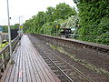 Frescati railway stop, while it was still in service
 -
 Villa Frescati. 2010


References
- ^ "Desprez, Jean-Louis". Svenskt biografiskt handlexikon. Retrieved August 1, 2019.
- ^ "Gustaf Mauritz Armfelt". Biografisket Lexikon of Finland. Archived from the original on June 6, 2010. Retrieved August 1, 2019.
- ^ "Villa Frescati". nationalstadsparken.se. Retrieved August 1, 2019.