
Frisia
Frisia | |
|---|---|
Frisian | |
| Integrated parts of Germany and the Netherlands with varying degrees of autonomy | |
| Area | |
• Narrow sense | 9,378.7 km2 (3,621.1 sq mi) |
• Broad sense | 13,482.7 km2 (5,205.7 sq mi) |
| Population | |
• Narrow sense | 1,475,380 (in 2,020) |
• Broad sense | 2,678,792 (in 2,020) |
| Time zone | UTC+1 (CET) |
• Summer (DST) | UTC+2 (CEST) |
Frisia[a] is a cross-border cultural region in Northwestern Europe. Stretching along the Wadden Sea, it encompasses the north of the Netherlands and parts of northwestern Germany. Wider definitions of ‘Frisia’ may include the island of Rem and the other Danish Wadden Sea Islands. The region is traditionally inhabited by the Frisians, a West Germanic ethnic group.
Etymology
The contemporary name for the region stems from
During the French occupation of the Netherlands, the name for the Frisian department was Frise. In English, both "Frisia" and "Friesland" may be interchangeably used to refer to the region.
Subdivisions
Frisia is commonly divided into three sections:
- Gronings, a Low Saxon dialect with a strong Frisian substrate. Rural Groningen originally belonged to the Frisian lands "east of the Lauwers" and is therefore more closely linked to East Frisia than to the west. In West Friesland, West Frisian Dutch – a Hollandic dialectwith strong Frisian influences – is spoken.
- East Frisia in Lower Saxony, Germany roughly corresponds to the historical regions of East Frisia (Aurich, Leer, Wittmund and Emden) and Oldenburger Friesland (Friesland and Wilhelmshaven), and the municipality of Saterland. In a broader sense, it also includes the Butjadingen peninsula (former Rüstringen) and Land Wursten. Usually, only the people from East Frisia proper (German: Ostfriesland) refer to themselves as East Frisians. The German name Ostfriesland distinguishes the historical region from Ost-Friesland, which refers to East Frisia as a whole.
- Nordfriesland and the archipelago of Heligoland. It includes the North Frisian Islands, where varieties of the North Frisian language are spoken. It stretches from the Eider River in the south to the border of Denmark in the north. Until the Second Schleswig War in 1864, the region belonged to the Danish Duchy of Schleswig.
| Section | Subdivision | Flag | Population (2020) | Area |
|---|---|---|---|---|
| North Frisia | Nordfriesland | 167,147 | 2,047 km2 (790 sq mi) | |
| Heligoland | 1,307 | 1.7 km2 (0.66 sq mi) | ||
East Frisia
|
Ostfriesland (Aurich, Emden, Leer, Wittmund) | 468,919 | 3,142 km2 (1,213 sq mi) | |
| Oldenburger Friesland (Friesland, Wilhelmshaven) | 174,160 | 715 km2 (276 sq mi) | ||
| Saterland | 13,903 | 124 km2 (48 sq mi) | ||
| Rüstringen (Butjadingen peninsula) | 45,538 | 423 km2 (163 sq mi) | ||
| Land Wursten | 17,101 | 182 km2 (70 sq mi) | ||
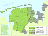
| West Frisia | Fryslân
|
649,944 | 3,349 km2 (1,293 sq mi) | |
| West Friesland | 554,464 | 1,174 km2 (453 sq mi) | ||
| Ommelanden (Groningen) | 586,309 | 2,325 km2 (898 sq mi) |
History
Roman era
The people, later to be known as
Early Middle Ages


Frisian presence during the Early Middle Ages has been documented from North-Western Flanders up to the Weser River Estuary. According to archaeological evidence, these Frisians were not the Frisians of Roman times, but the descendants of Anglo-Saxon immigrants from the
Distant authors seem to have made little distinction between Frisians and Saxons. The Byzantine
During the 7th and 8th centuries, Frankish chronologies mention the northern Low Countries as the kingdom of the Frisians. According to Medieval legends, this kingdom comprised the coastal seelande provinces of the Netherlands, from the Scheldt River to the Weser River and further East. Archaeological research does not confirm this idea, as the petty kingdoms appear to have been rather small and short-lived.
The earliest Frisian records name four social classes, the
The basic land-holding unit for assessment of taxes and military contributions was – according to Homans – the ploegg (cf. "plow") or teen (cf.
The 7th-century Frisian Realm (650–734) under the kings
During the 7th to 10th centuries, Frisian merchants and skippers played an important part in the international luxury trade, establishing commercial districts in distant cities as Sigtuna, Hedeby, Ribe, York, London, Duisburg, Cologne, Mainz, and Worms.
The establishment of the Frisian trade network played a significant role in maintaining regional peace during the late Middle Ages. While interpersonal violence was on the rise almost everywhere else in Europe, Northern Europe and especially Frisia managed to maintain low levels of violence due in part to its well-developed society and established rule of law, which were results of extensive trade.[7]
The Frisian coastal areas were partly occupied by
Upstalsboom League
During the 12th century Frisian noblemen and the city of
15th century

The 15th century saw the demise of Frisian republicanism. In
Modern age
In the early 16th century, the pirate and freedom fighter Pier Gerlofs Donia (Grutte Pier) challenged Saxon authority in Friesland during a prolonged guerrilla war, backed by the Duke of Guelders. He had several successes and was feared by Hollandic authorities, but he died as a farmer in 1520. According to the legend he was seven feet tall. A statue of Grutte Pier by Anne Woudwijk was erected in Kimswert in 1985.
In the 1560s many Frisans joined the revolt led by William of Orange against the Habsburg monarchy. In 1577 the province of Friesland became part of the nascent Dutch Republic, as its representatives signed the Union of Utrecht. The city of Groningen was conquered by the Dutch in 1594. Since then, membership of the Dutch Republic was perceived as a guarantee for the preservation of civil liberties. Actual power, however, was usurped by the landowning gentry. Protests against aristocratic rule led to a democratic movement in the 1780s.
Frisian territories
- When West Friesland was conquered by the County of Holland in 1289, this was the end of a series of wars between the county of Holland and Friesland that started at the end of the 11th century. The Dutch conquest occurred immediately after the disastrous St. Lucia's flood in which many Frisians in the area were killed. After the conquest the district of West Friesland, which also comprised the islands of Wieringen, Texel, and Vlieland, had its own seats in the Estates of Holland and West Friesland. When the province of Holland was split up in the constitutional reform of 1840, West-Friesland became a part of North Holland. The name of West Friesland has also been used by an intercommunal administrative board (samenwerkingsregio) and a water board.
- Frieslandbecame an independent member of the Dutch Republic in 1581. It is now a Dutch province, in 1996 renamed as Fryslân.
- The islands of Terschelling, Ameland, and Schiermonnikoog were independent seignories, which were integrated into the province of Friesland during the 19th and 20th centuries.
- Groningen, formerly Stad en Lande (the city of Groningen and its surroundings), became an independent member of the Dutch Republic in 1594. Now it is a Dutch province. As a rule, its inhabitants do not consider their province as a part of Frisia, though the area has many cultural ties with neighbouring East Frisia.
- Federal Republic of Germany.
- Harlingerland was a seignory, inherited by the count of East Frisia in 1600.
- Jever was a seignory, annexed by the County of Oldenburg in 1573 and, after a prolonged period of Saxony-Anhalt, Russian, Dutch and French rule, reunited with Oldenburg in 1814. It is now part of the district of Friesland within the federal state of Lower Saxony.
- Kniphausenwas a seignory, split off from the County of Oldenburg in 1667 and reunited with its surroundings in 1854 (effectively in 1813).
- Kingdom of Hannover.
- Butjadingen was a coastal republic, a remnant of the largely submerged district of Rüstringen. It was conquered by the Count of Oldenburg in 1514. After a period of Danish rule, it became part of the Duchy of Oldenburg in 1774, which remained a more or less independent state within the German Empire until 1918. Butjadingen is now part of the district of Wesermarsch within the federal state of Lower Saxony.
- Land Wursten was a coastal republic, conquered by the Prince-bishop of Bremen in 1525. It became part of the Duchy of Bremen-Verden. The latter was, after a period of Swedish rule, integrated into the Kingdom of Hanover in 1715. It is now part of the district of Cuxhaven within the federal state of Lower Saxony.
- Helgoland is part of the district of Pinneberg. North Frisia was never a part of the Holy Roman Empire.
Contemporary regionalism
During the late 19th and early 20th century, "Frisian freedom" became the slogan of a regionalist movement in Friesland, demanding equal rights for the Frisian language and culture within the Netherlands. The West Frisian language and its urban dialects are spoken by the majority of the inhabitants. In East Frisia, the idea of "Frisian freedom" became entangled with regional sentiments as well, though the East Frisian language had been replaced by Low German dialects as early as the 15th century. In Groningen, on the other hand, Frisian sentiments faded away at the end of the 16th century. In North Frisia, regional sentiments concentrate around the surviving North Frisian dialects, which are spoken by a sizeable minority of the population, though Lower German is far more widespread.
Regional political parties
| Political party | Active in | Representation | European affiliation | ||
|---|---|---|---|---|---|
| DF | Die Friesen De Freesen |
None | None | ||
| FNP | Frisian National Party Fryske Nasjonale Partij |
Friesland
|
EFA | ||
| SSW | South Schleswig Voters' Association Söödslaswiksche Wäälerferbånd |
EFA | |||
Languages
A half-million Frisians in the province of Friesland in the Netherlands speak
Maps
-
 Location of Frisia (dark orange) in Europe
 -
 Historical settlement areas of the Frisians, and areas where a Frisian language is spoken
 -
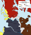
 The Frisian territories in Lower Saxony (East Frisia)
 -
 Frisian colonisation (yellow) of southwestern Jutland during the Viking Age
 -
 Difference between the historical region and present-day district of Nordfriesland


Flag


While the subdivisions of Frisia have their own regional flags, Frisia as a whole has not historically had a flag of its own. In September 2006, a flag for a united Frisia – known as the "Interfrisian Flag" – was designed by the
The design was not accepted by the Interfrisian Council.[9] Instead, the council adopted the idea of an Interfrisian flag and created a design of its own, containing elements of the flags of the council's three sections. Neither of the two flags is widely used.
See also
- Frisian Islands
- Frisian languages
- Frisian cuisine
- List of rulers of Frisia
- Eala Frya Fresena
- Stateless nation
- German Bight
- Wadden Sea
- Zuider Ee
Notes
- ^
- Dutch, German: Friesland
- Dutch Low Saxon: Fraislaand
- East Frisian Low Saxon: Fräisland
- North Frisian (Amrum, Föhr): Fresklun
- North Frisian (Bökingharde): Fraschlönj
- North Frisian (Goesharde): Freeschlon
- North Frisian (Halligen): Freesklöön
- North Frisian (Heligoland): Friislon
- North Frisian (Karrharde): Fräischlön
- North Frisian (Sylt): Friislön
- North Frisian (Wiedingharde): Freesklön
- Saterland Frisian: Fräislound [ˈfrɛi̯slɔu̯nd]
- West Frisian: Fryslân
- JSTOR 3292503.
- : 189
- ^ This is part of the evidence for a duodenary system, counting by multiples of twelve.[6] : 204 and passim
References
- ^ cf. Fort, Marron Curtis (1980): Saterfriesisches Wörterbuch. Hamburg, p.45.
- ISBN 9783484730489. Retrieved 2009-01-11.: 480
- ^ Tacitus. Annales IV (in Latin).
- ^ "Frisian language". Encyclopedia Britannica. Retrieved 2017-11-13.
- ^ Procopius (1914). The Wars. 8.20.11-46
- ^ JSTOR 2590857.
- ^ Baten, Joerg; Steckel, Richard H. (2019). "The History of Violence in Europe: Evidence from Cranial and Postcranial Bone Traumata". The Backbone of Europe: Health, Diet, Work and Violence over Two Millennia: 300–324.
- ^ "Interfrisian flag". Groep fan Auwerk. September 2006.
- ^ Press release from the Interfrisian Council
- Bibliography
- Thomas Steensen: 'Die Friesen. Menschen am Meer', Wachholtz Verlag, Kiel/Hamburg 2020, ((ISBN 978-3-529-05047-3)).
- Albert Bantelmann, Rolf Kuschert, Albert Panten, Thomas Steensen: Geschichte Nordfrieslands. 2., durchges. u. aktualisierte Aufl., Westholst. Verlagsanstalt Boyens, Heide in Holstein 1996 (= Nordfriisk Instituut, Nr. 136), ISBN 3-8042-0759-6.
- Thomas Steensen: Geschichte Nordfrieslands von 1918 bis in die Gegenwart. Neuausg., Nordfriisk Instituut, Bräist/Bredstedt 2006 (= Geschichte Nordfrieslands, Teil 5; Nordfriisk Instituut, Nr. 190), ISBN 3-88007-336-8.
- Stefan Kröger - Das Ostfriesland-Lexikon. Ein unterhaltsames Nachschlagewerk, Isensee Verlag, Oldenburg 2006
- Ostfriesland im Schutze des Deiches. Beiträge zur Kultur- und Wirtschaftsgeschichte des ostfriesischen Küstenlandes, hrsg. im Auftrag der Niederemsischen Deichacht, 12 Bände, Selbstverlag, Pewsum u. a. 1969
- Onno Klopp -, Geschichte Ostfrieslands, 3 Bde., Hannover 1854–1858
- Hajo van Lengen - Ostfriesland, Kultur und Landschaft, Ruhrspiegel-Verlag, Essen 1978
- Hajo van Lengen (Hrsg.) - Die Friesische Freiheit des Mittelalters – Leben und Legende, Verlag Ostfriesische Landschaft 2003, ISBN 3-932206-30-4
- ISBN 3-87829-082-9
- Karl Cramer - Die Geschichte Ostfrieslands. Ein Überblick, Isensee - Oldenburg
- Hermann Homann - Ostfriesland – Inseln, Watt und Küstenland, F. Coppenrath Verlag, Münster
- Manfred Scheuch - Historischer Atlas Deutschland, ISBN 3-8289-0358-4
- Karl-Ernst Behre / Hajo van Lengen - Ostfriesland. Geschichte und Gestalt einer Kulturlandschaft, Aurich 1995, ISBN 3-925365-85-0
- Tielke, Martin (ed.) - Biographisches Lexikon für Ostfriesland, Ostfries. Landschaftliche Verlag- u. Vertriebsges. Aurich, vol. 1 ISBN 3-932206-22-3(2001)
External links
- Profile at Eurominority.eu
- Official website of the Interfrisian Council
- Website of the Groep fan Auwerk