
Friuli-Venezia Giulia
Friuli-Venezia Giulia
Friûl Vignesie Julie ( Autonomous region | ||
|---|---|---|
|
ISO 3166 code IT-36 | | |
| HDI (2021) | 0.905[2] very high • 7th of 21 | |
| NUTS Region | ITD | |
| Website | www | |
Friuli-Venezia Giulia
Friuli-Venezia Giulia has an area of 7,924 square kilometres (3,059 sq mi) and about 1.2 million inhabitants. A natural opening to the sea for many central European countries, the region is traversed by the major transport routes between the east and west of Southern Europe. It encompasses the historical-geographical region of Friuli and a small portion of the historical region of Venezia Giulia – also known in English as the Julian March – each with its own distinct history, traditions and identity.
Name
Friuli comes from the Latin term Forum Julii ("Julius' forum"), a center for commerce in the Roman times, which today corresponds to the city of Cividale.[10] The denomination Venezia Giulia ("Julian Venetia", not referring to the city of Venice but to the Roman province of Venetia et Histria) was proposed by the Italian linguist Graziadio Isaia Ascoli, with the intention of marking the Italian cultural spirit of the area.[10]
History
This section needs additional citations for verification. (July 2021) |

In Roman times, modern Friuli-Venezia Giulia was located within
Following the
In 774 Charlemagne conquered Lombard Italy and absorbed it into Francia (the Frankish Empire from 800), with the Lombard Duke of Friuli replaced by a Frankish one. In 787 Charlemagne established a new patriarch at Aquileia. The duchy was dissolved in 828 and partitioned into smaller counties. In 843 the Empire was partitioned in the Treaty of Verdun placing Friuli at the frontier between Middle Francia (later the Kingdom of Italy) and East Francia (later the Kingdom of Germany) and in 846 the former duchy was reconstituted as the March of Friuli. In 961 Otto the Great of Germany took control of Italy and established the Holy Roman Empire. In 1077, the Holy Roman Emperor recognized the territorial powers of the Patriarchate of Aquileia that temporarily extended its rule to areas to the east; however, by the 12th century the County of Gorizia had become independent. Trieste developed into the Imperial Free City of Trieste. The coastal territory between Gorizia and Trieste was controlled by the March of Carniola (Duchy of Carniola from 1364).

Friuli became
With the 1797
In 1815, following the end of the Napoleonic Wars, the Congress of Vienna returned the area to Austria: Friuli was included in the Kingdom of Lombardy–Venetia, while Gorizia and Trieste were assigned to the Kingdom of Illyria (both crown lands of the Austrian Empire), with the boundary roughly following the former Imperial-Venetian border. In 1849 Illyria was abolished and Gorizia and Trieste both became part of the Austrian Littoral crown land, along with Istria and several islands in the Kvarner Gulf.
Under the enlightened government and policies set by the Austrian Empire and continued by the
During the First World War, the region was a prominent theatre for military operations and suffered serious damage and loss of lives. After the war, the former Littoral was annexed by Italy in the
The Second World War led to the creation of the
The region's name was Friuli-Venezia Giulia (hyphenated) until 2001, when the official spelling Friuli-Venezia Giulia (without hyphen) was adopted following the modification of Article No.116 of the Italian Constitution.[12][13][14] The term "Venezia Giulia" was coined by Graziadio Isaia Ascoli.
Geography
Friuli-Venezia Giulia is Italy's north-easternmost
The region spans a wide variety of climates and landscapes from the mild Oceanic in the south to Alpine continental in the north. The total area is subdivided into 42.5% mountainous-alpine terrain in the north, 19.3% is hilly, mostly to the southeast, while the remaining 38.2% comprises the central and coastal plains.

Morphologically the region can be subdivided into four main areas. The mountainous area in the north: this part of the region includes
The area is also known for its tourist destinations, especially during the winter season (Monte Zoncolan, Tarvisio, Sella Nevea, Forni di Sopra and Piancavallo). The hilly area is situated to the south of the mountains and along the central section of the border with Slovenia. The main product of agriculture in this area is wine, whose quality, especially the white, is known worldwide. The easternmost part of the hilly area is also known as Slavia Friulana, as it is mostly inhabited by ethnic Slovenes.
The central plains are characterized by poor, arid, and permeable soil. The soil has been made fertile with an extensive irrigation system and through the adoption of modern intensive farming techniques. In this part of the region, most of the agricultural activities are concentrated. The coastal area can be further subdivided into two, western-eastern, subsections separated by the river
To the west, the coast is shallow and sandy, with numerous tourist resorts and the lagoons of

The rivers of the region flow from the North and from Slovenia into the
The region Friuli-Venezia Giulia has a temperate climate. However, due to the terrain's diversity, it varies considerably from one area to another. Walled by the Alps on its northern flank, the region is exposed to air masses from the East and the West. The region receives also the southerly Sirocco from the Adriatic Sea, which brings in heavy rainfall. Along the coast, the climate is mild and pleasant.
Trieste records the smallest temperature differences between winter and summer and between day and night. The climate is
Economy
This section contains content that is written like an advertisement. (January 2020) |
The Gross domestic product (GDP) of the region was 38 billion euros in 2018, accounting for 2.2% of Italy's economic output. GDP per capita adjusted for purchasing power was 31,200 euros or 103% of the EU27 average in the same year. The GDP per employee was 106% of the EU average.[15]

The economy of Friuli-Venezia Giulia is one of Italy's most successful. Its core is based on small and middle-size enterprises (the so-called "North-East model"), on specialized farming and on high-quality tourism with a significant inclination towards exports.[16]
Agriculture and farming maintain an essential role in the economy of the region and employed in 2001 around 95,000 persons. Its products are exported not only within the country and Europe (fruit and vegetables, cheese) but have become known worldwide for their acclaimed quality (cured ham and wines, especially white ones). Noteworthy is also the production of soy (third producer in Italy with more than 37,000 hectares cultivated in 2000) and timber production in Carnia.[16]
The economy of the region is based on a widespread mosaic of small and medium-sized enterprises; of particular importance are the four industrial districts where a multitude of highly specialised enterprises are concentrated. These districts are centred around the towns of

In the services sector, the city of Trieste plays a leading role (with knock-on effects on the other provincial capitals); it is here that activities such as the regional government, large banking, and insurance companies are concentrated.
The unemployment rate stood at 5.7% in 2020.[17]
Transport
With its commercial Free Port, Trieste also plays an essential role in the trade sector: special custom regulations ensure exclusive financial conditions to operators. The Port of Trieste is today the most important centre worldwide for the trade of coffee and plays a strategic key role in trade with northern and eastern Europe.[16]

Although small in size, Friuli-Venezia Giulia has always been 'in the centre of Europe' and has played an important role in connecting Italy (and the Mediterranean) to Central and Eastern Europe. Its role will become even more strategic as a logistical platform with the imminent enlargement of the European Union. Hence the importance of the infrastructure network of the region, which can today be considered first-rate in quality and diversity. The motorway network consists of more than 200 km that runs from North to South and from West to East, connecting the region to Austria and Slovenia.[16]
The railway network consists of around 500 km of track, with the two twin-line 'backbones' Venice-Trieste and Trieste-Udine-Tarvisio-Austria. The motorway and railway networks are linked to the ports of Trieste, Monfalcone, and Porto Nogaro, the three most northerly ports of the Mediterranean. Trieste, in particular, has a free port for goods since 1719. It is the Italian port with the greatest capacity for covered storage, with a surface area of more than 2 million square meters and 70 km of rail tracks. Intermodality is guaranteed by the Cervignano terminal, in operation since 1988, to serve the increasing commercial traffic between Italy and Eastern European countries.[16]
The regional airport of Ronchi dei Legionari is situated 30 km from Trieste and 40 km from Udine and is closely connected to the motorway and railway networks. The airport offers regular national and international flights including destinations in Eastern Europe. The region is now placing much of its hopes for future economic development in the construction of a high-speed European Transport Corridor n° V connecting Lyon, Turin, Venice, Trieste, Ljubljana, Budapest, and Kiev, so as to improve the traffic of goods and services with new EU partners.[16]
Tourism
Friuli-Venezia Giulia has many small and picturesque villages, 13 of them have been selected by I Borghi più belli d'Italia (English: The most beautiful Villages of Italy),[18] a non-profit private association of small Italian towns of strong historical and artistic interest,[19] that was founded on the initiative of the Tourism Council of the National Association of Italian Municipalities.[20]
Demographics
| Year | Pop. | ±% |
|---|---|---|
| 1871 | 508,000 | — |
| 1881 | 530,000 | +4.3% |
| 1901 | 615,000 | +16.0% |
| 1911 | 728,000 | +18.4% |
| 1921 | 1,178,000 | +61.8% |
| 1931 | 1,176,000 | −0.2% |
| 1936 | 1,108,000 | −5.8% |
| 1951 | 1,227,674 | +10.8% |
| 1961 | 1,205,821 | −1.8% |
| 1971 | 1,214,946 | +0.8% |
| 1981 | 1,235,363 | +1.7% |
| 1991 | 1,199,039 | −2.9% |
| 2001 | 1,185,123 | −1.2% |
| 2011 | 1,220,291 | +3.0% |
| 2021 | 1,194,647 | −2.1% |
| Source: ISTAT 2001 | ||
Population density is lower than the national average: In 1978 there were in total only 1,224,611 inhabitants;[21] in 2008 it was 157.5 inhabitants per km2 (compared to 198.8 for Italy as a whole). However, density varies from a minimum of 106 inhabitants per km2 in the province of Udine to a maximum of 1,144 inhabitants per km2 in the province of Trieste.
The negative natural balance in the region is partly made up by the positive net migration. To some extent the migratory surplus has in fact offset the downward trend in the population since 1975. In 2008, the resident population with foreign nationality registered in the region accounted to 83,306 persons (6.7% of the total population).
Government and politics
This section needs additional citations for verification. (July 2021) |
.jpg)
A special Italian statute of 31 January 1963 effective 16 February 1963 constituted Friuli-Venezia Giulia as an
The
Administrative divisions
Like most of the rest of Italy, Friuli-Venezia Giulia was previously divided into four provinces: Gorizia, Pordenone, Trieste and Udine. They were abolished on 30 September 2017, with the first three immediately ceasing activity,[22] while the province of Udine remained active until 22 April 2018.[23] In 2019, they were all reactivated as "regional decentralization entities" (Italian: Enti di decentramento regionale, or EDR) beginning on 1 July 2020.[24]
In anticipation of this 2017 and 2018 abolition of the provinces in Friuli-Venezia Giulia, the
The Regional Council also passed a statute which allows, should it desire at some future point, for the establishment of the regional capital of Trieste – with smaller surrounding towns – as a metropolitan city administering wide area local development policies.
Intermunicipal Territorial Unions (UTI)

Regional decentralization entities


Until 2017–18, Friuli-Venezia Giulia was divided into four provinces. The Regional Council voted to abolish them effective 30 September 2017,[22] though the provincial council of the largest, Udine, carried on some administrative responsibilities until 22 April 2018.[23] They have again been active since 1 July 2020 under the administrative form of regional decentralization entities or EDRs.[24]
| EDR (listed west to east) |
Area (km2) |
Population | Density (inh./km2) |
|---|---|---|---|
| Pordenone | 2,273 | 311,931 | 137.2 |
| Udine | 4,905 | 539,224 | 109.9 |
| Gorizia | 466 | 142,392 | 305.5 |
| Trieste | 212 | 236,445 | 1,115.3 |
Culture
Language

The official languages of the region are Italian, Friulian, Slovene and German.[9]
Venetian is also spoken in western part of the Province of Pordenone, and in the city of Pordenone itself, due to its proximity with the Veneto region. Friulian and Venetian are more common in the countryside, while standard Italian is the predominant language in the larger towns (Udine, Pordenone, Gorizia). The region is also home to Italy's Slovene-speaking minority.[citation needed]
Historical flag
A very popular symbol among the Friulian community (mostly identified with the friulian-speaking population in the provinces of Udine, Pordenone and Gorizia and the numerous expat communities around the world) is the Friulian Historical Flag, to which the official regional flag is roughly inspired, being somehow a modern interpretation of it. The official, modern "Friuli-Venezia Giulia" flag logo was issued in 1967–1968[28] (and adopted in 2001) to represent the region which in 1963[29] took the administrative setup of today. The historical symbol of the eagle dates back to (at least) the 13th century, the time of the Patriarchate of Aquileia.[citation needed]
Gallery
-
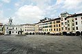 Piazza San Giacomo in Udine
 -
 The Miramare Castle in Trieste
 -
 The lake of Fusine in Valromana
 -
 The Devil's Bridge in Cividale del Friuli
 -
 Terrazza Mare in Lignano Sabbiadoro
 -
 The Grado lagoon
 -
 The bay of Sistiana
 -
 Piazza Unità d'Italia in Trieste
 -
 The sea in Trieste
 -
 Sanctuary in Mount Lussari, Tarvisio
 -
 The Tagliamento river near Pinzano
 -
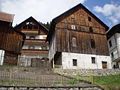 Typical houses in Carnia


.jpeg)
.jpg)


See also
Notes
- ^ Usage of the hyphen, even in official sources, is inconsistent. While it is present in the Constitution of Italy, the region is also referred to as Friuli Venezia Giulia in other sources.[3][4]
- ^ It may be pronounced /friˌuːli vɛˌnɛtsiə ˈdʒuːliə/ in British English, and /- veɪˌnɛtsiə ˈdʒuːljə/, /- vɛˌnɛtsjə ˈdʒuːljə/, or /ˌfriːəli vəˌniːtsiə ˈdʒuːljə/ in American English.[5][6][7][8]
- Austrian German: Friaul-Julisch Venetien.[9]
References
- ^ "Population on 1 January by age, sex and NUTS 2 region", www.ec.europa.eu
- ^ "Sub-national HDI - Area Database - Global Data Lab". hdi.globaldatalab.org. Retrieved 5 March 2023.
- ^ Londero, Hubert (6 May 2017). "Il mistero del trattino scomparso". IlFriuli.it (in Italian). Retrieved 18 August 2023.
- ^ "Friuli-Venezia Giulia". Italia.it (in Italian). Retrieved 27 December 2023.
- ^ "Friuli-Venezia Giulia". The American Heritage Dictionary of the English Language (5th ed.). HarperCollins. Retrieved 6 May 2019.
- ^ "Friuli-Venezia Giulia".[dead link]
- ^ "Friuli-Venezia Giulia". Lexico UK English Dictionary. Oxford University Press. Archived from the original on 23 August 2022.
- ^ "Friuli-Venezia Giulia". Merriam-Webster.com Dictionary. Retrieved 6 May 2019.
- ^ a b "Regione Autonoma Friuli-Venezia Giulia – Comunità linguistiche regionali". www.regione.fvg.it.
- ^ a b "Friuli-Venezia Giulia: l'origine del nome". UdineToday (in Italian). Retrieved 3 August 2023.
- ^ "Sito Ufficale della Regione Autonoma Friuli–Venezia Giulia – Versione Inglese". Regione.fvg.it. Retrieved 5 May 2009.
- ^ "Modifiche al titolo V della parte seconda della Costituzione". parlamento.it. 18 October 2001.
- ^ "Costituzione della Repubblica Italiana" (PDF) (in Italian). Archived from the original (PDF) on 20 June 2006. Retrieved 10 September 2014.
- ^ Sarti, Gianpaolo: La Lega lancia la regione "Friuli e Trieste", in: Il Piccolo, 9 September 2014, p. 14.
- ^ "Regional GDP per capita ranged from 30% to 263% of the EU average in 2018". Eurostat.
- ^ a b c d e f g "Eurostat". Circa.europa.eu. Archived from the original on 18 April 2010. Retrieved 5 May 2009.
- ^ "Unemployment NUTS 2 regions Eurostat".
- ^ "Friuli Venezia Giulia" (in Italian). Retrieved 31 July 2023.
- ^ "Borghi più belli d'Italia. Le 14 novità 2023, dal Trentino alla Calabria" (in Italian). Retrieved 28 July 2023.
- ^ "I Borghi più belli d'Italia, la guida online ai piccoli centri dell'Italia nascosta" (in Italian). Retrieved 3 May 2018.
- ^ Prost, Brigitte: Le Frioul.Région d#affrontements, Géneve 1973.
- ^ a b "Soppressione delle Province del Friuli-Venezia Giulia" [Suppression of the Provinces of Friuli-Venezia Giulia]. Consiglio regionale del Friuli-Venezia Giulia (in Italian). 14 December 2016. Archived from the original on 23 October 2017. Retrieved 24 December 2021.
- ^ a b "Nomina del commissario liquidatore" [Appointment of the liquidator commissioner]. Provincia di Udine (in Italian). 16 May 2018. Retrieved 20 April 2019.
- ^ a b "Focus sugli Enti di decentramento regionale". IlFriuli.it (in Italian). 22 September 2020. Retrieved 18 August 2023.
- ^ "Enti locali: Approvata la proposta del piano di riordino territoriale del FV" [Local authorities: Approved the proposal of the territorial reorganization plan of the FV] (in Italian). 4 February 2015. Retrieved 20 April 2019.
- ^ "Local development challenges and the role of "wide areas" in strategic planning. The case of inter-municipal territorial unions of Friuli-Venezia Giulia (Italy)". iris.unibocconi.it. Retrieved 18 February 2021.
- ^ "Unioni Territoriali intercomunali (UTI)" (PDF). Archived from the original (PDF) on 24 December 2016. Retrieved 23 April 2017.
- ^ "pending" (PDF). Archived from the original on 4 March 2016. Retrieved 31 October 2020.
- ^ "pending". Archived from the original on 22 January 2020. Retrieved 31 October 2020.
External links
- "The official website for tourism of Friuli-Venezia Giulia. Welcome". Friuli-Venezia Giulia.
- "Metro.fvg: Regione Autonoma Friuli-Venezia Giulia". OSMER: Osservatorio Meteorologico Reginale.
| Provinces and places | | |
|---|---|---|
| History | ||
| Politics and government | ||
| Education and culture | ||