
Furness

Furness (
The Furness Peninsula, also known as Low Furness, is an area of villages, agricultural land and low-lying moorland, with the industrial town of Barrow-in-Furness at its head. The peninsula is bordered by the estuaries of the River Duddon to the west and the River Leven in Morecambe Bay to the east. The wider region of Furness consists of the peninsula and the area known as High Furness, which is a relatively mountainous and sparsely populated part of England, extending inland into the Lake District and containing the Furness Fells.[2] The inland boundary of the region is formed by the rivers Leven, Brathay and Duddon, and the lake of Windermere. Off the southern tip of Furness is Walney Island, 11 miles (18 kilometres) long, as well as several smaller islands.
The Borough of Barrow-in-Furness, which developed when the Furness iron industry flourished in the 19th century, is the region's largest settlement, with a population of over 91,000.[3] The remainder of Furness is predominantly rural, with Ulverston the only other settlement with more than 10,000 people. Much of High Furness consists of moorland, mountain or woodland environments.
Etymology
The name, which is first recorded in 1150 as Fuththernessa, is interpreted as "headland by the rump-shaped island," from Old Norse futh (genitive futhar), meaning rump, and nes, meaning headland.[4] The island in question may be Piel Island, with the name originally referring to the headland immediately opposite (where Rampside is), before being extended to the entire region.[5] Alternatively it could be Walney Island: though it little resembles a rump today, erosion could have altered its shape over time.[6]
Geography

Furness's border follows the River Duddon up to Wrynose Pass, and then the Brathay until it flows into Windermere. The mere forms most of the eastern boundary, with the rest being made up of the Leven, from its source at Windermere's southern tip to its mouth at Morecambe Bay.[5] In total Furness has an area of about 250 square miles (650 square kilometres).[7]
The Furness Fells are formed of
The human geography of the area is dominated by the town of
The A590 is the main road into the region from the
History

Furness seems to have been scantly populated in ancient times.[5] A handful of Brittonic placenames survive around Barrow, suggesting this part was settled earliest.[5] Anglo-Saxons arrived in Low Furness in the 7th century, but do not seem to have spread to High Furness, which remained almost empty until it was populated by incoming Scandinavians in the 10th century.[5] It has been suggested that they had a small mountain kingdom there, centred on Coniston (which means "king's town").[5] The prevalence of names with the element "thwaite" in High Furness (from Norse thveit, "clearing"), and the absence thereof in Low Furness, suggests that the latter had already been deforested by the time the Scandinavians arrived.[5] Scandinavians probably formed the majority of the Furness population, and Old Norse remained a living language in the region until at least the late 12th century.[5]
Before the Conquest, Furness, assessed to contain 82
In the 14th century Dalton Castle and Piel Castle were built by the abbots of Furness to defend the market town of Dalton and the port of Barrow respectively. The area had been raided by Scots in 1316 and again in 1322,[9] though in the latter year the abbot paid Robert the Bruce a ransom to stop his men harrying Low Furness.[13]
The pretender Lambert Simnel landed with his army at Piel Island in 1487. A few locals joined him, including Sir Thomas Broughton of Broughton Tower, who would be killed at the disastrous Battle of Stoke Field.[14]
The abbey was closed in 1536 after the monks lent their support to the Pilgrimage of Grace, and the abbot's lands were seized by the crown, becoming part of the royal duchy of Lancaster.[7] Later they were granted to the dukes of Buccleuch[9] and Devonshire.[7]
In May 1643, Furness was occupied and plundered by a large Royalist force commanded by Richard Viscount Molyneux. Later that year they prepared to march to the relief of Thurland Castle in South Lonsdale, then besieged by Colonel Rigby, but Rigby took some of his men over the sands and met the Royalists at Lindal, where they were routed. The Parliamentarians looted the Dalton neighbourhood before retreating to Cartmel the same night. In 1644 the Royalists remained in control of Furness, though the country folk were hostile to them, and Parliament ships landed at Piel Island to aid in a rising. After a fight at Hawcoat the resistance was quashed, and the Parliament ships left for Liverpool. After collecting the king's rents, the Royalists left for Cartmel. After the Restoration of the monarchy, one Furness landowner, Colonel Sawry, attempted a rising.[9]

Iron had been mined in Furness since prehistory, and by the late 18th century ore was being exported from Barrow. The
Tourism in High Furness was promoted by the writings of
Shipbuilding later replaced iron and steel as Low Furness's main industry, and Barrow's shipyards became the largest in England. In particular, submarine development became a specialty of the town, with the Royal Navy's first submarines built there. During the wars this allowed Furness to escape many of the economic problems that other areas suffered, due to the constant work provided by the military.
After World War II demand for ships and submarines remained high, while the development of the Lake District National Park further fostered tourism. Attractions such as the Lakeside and Haverthwaite Railway, steamers on Windermere and Coniston Water, and fell walking, caused parts of Furness to become dependent on the tourist trade.
In the early 1990s, the decline of shipbuilding led to mass redundancies in the area. The shipyard's employment figures fell from 20,000 to 3,000 in a 20-year period. However, the shipyard at Barrow remains England's busiest and the only
Transport has become an increasingly controversial issue, with conservation groups and local business clashing over the need for improvements to the
Administration

Furness formed the greater part of the North Lonsdale exclave of the historic county of Lancashire, which bordered Cumberland to the northwest and Westmorland to the northeast (the point where the three counties met is marked by the Three Shire Stone at the head of the Duddon). North Lonsdale is also called "Lancashire North of the Sands".
In 1974, North Lonsdale – along with Cumberland, Westmorland, and part of the West Riding of Yorkshire (around Sedbergh) – became part of the new administrative county of Cumbria.
At the district level, it now consists of the borough of Barrow and part of South Lakeland.
From April 2023, Furness will form part of the new unitary council area of Westmorland and Furness, which will replace Cumbria County Council and the districts of Barrow and South Lakeland, all of which will be abolished.
Low Furness and the western part of High Furness are in the
Notable people
- Stan Laurel
- Emlyn Hughes
- Myles Burton Kennedy
- Christine McVie
- Dave Myers (presenter)
- Ben Palmer
- Henry Robinson Hall
- George Romney
- Miles Romney
- Georgia Stanway
Gallery
-
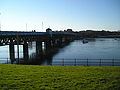 Jubilee Bridge, linking Barrow Island and Walney Island
 -
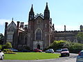 Conishead Priory, near Ulverston
 -
 Piel island and castle
 -
 Scenery near Broughton in the winter
 -
 The Old Man of Coniston from Coniston village
 -
 Coniston Water
 -
 View of Windermere from Latterbarrow


_-_geograph.org.uk_-_1540675.jpg)


References
- ISBN 978-0-521-15255-6.
- ^ "Furness area". Furness Family History Society.
- ^ Population data for northwest England, from the 2011 census, Furness being defined as the borough of Barrow and the South Lakeland output areas 007A, 008, 012, and 014.
- ^ Mills, David (2011). A Dictionary of British Place-Names. Oxford University Press.
- ^ a b c d e f g h Rajala, Heikki (2009–2010). "English Place-Names" (PDF). Innervate. 2. Nottingham University.
- ISBN 9780091940430.
- ^ a b c Chisholm, Hugh, ed. (1911). . Encyclopædia Britannica. Vol. 11 (11th ed.). Cambridge University Press. pp. 362–363.
- ^ ISBN 9781848021556.
- ^ a b c d e f g Farrer, William; Brownbill, John, eds. (1914). "The Parish of Furness". A History of the County of Lancaster. Vol. 8. Victoria County History.
- ^ Nugent, Helen (16 July 2012). "Census shows Barrow-in-Furness suffered steepest decline in population". The Guardian. Retrieved 24 November 2017.
- ^ Roberts, E. (1977). Working-class women in the North West. Oral History, 5(2), 7-30.
- ^ "Low Furness and Ulverston, Local Area Partnership" (PDF). South Lakeland. Retrieved 24 November 2017.
- ^ "The Great Raid of 1322". Barrow History Society.
- ^ "Lambert Simnel's Landing on Piel Island". Barrow History Society. Archived from the original on 4 March 2016. Retrieved 16 October 2016.
- ^ Chisholm, Hugh, ed. (1911). . Encyclopædia Britannica. Vol. 03 (11th ed.). Cambridge University Press. p. 443.
External links
 Media related to Furness at Wikimedia Commons