
The Fylde
The Fylde (
Geography
It is a flat, alluvial plain, parts of which have deposits of and were once dug for peat. The River Wyre meanders across the Fylde from Garstang on the eastern edge, westwards towards Poulton and then northwards to the sea at Fleetwood. The area north and east of the tidal Wyre, known as Over Wyre, is the more rural side of the river. The Fylde is roughly trisected by the M55 motorway and A586 road.
The west coast is almost entirely urban, containing the towns of
Geology
The Fylde is underlain by
The Quaternary cover consists of glacial
Governance
 The Borough of Fylde |
 FY postcode area |
The
The
Gallery
-
 Ribble estuary, looking west, separating the West Lancashire Coastal Plain (left) from the Fylde (right)
 -
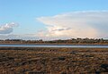 Countryside near the Wyre Estuary
 -
 Fylde coast, aerial photograph


See also
- Public transport in the Fylde
- Fylde Rugby Club
- Fylde (UK Parliament constituency) (1983 to date)
- Blackpool & Fylde Aero Club v Blackpool Borough Council[1990] EWCA Civ 13 is a leading English contract law case on the issue of offer and acceptance in relation to Call for Bids such as in tendering.
References
- ISBN 9789401064569
- ^ "British Geological Survey 1:50000 Series, England and Wales sheet 74 Southport, Solid and Drift geology". Maps Portal. British Geological Survey. Retrieved 5 July 2020.
- ^ "GeoIndex Onshore". British Geological Survey. Retrieved 5 July 2020.
- ^ "Geological Survey of Great Britain (England and Wales), Blackpool, Sheet 66, 1:50000 Series, Solid and Drift Edition with Bouguer anomalies". Maps Portal. British Geological Survey. Retrieved 5 July 2020.
| International | |
|---|---|
| National | |