
Galdhøpiggen
| Galdhøpiggen | |
|---|---|
Ultra | |
| Coordinates | 61°38′11″N 8°18′45″E / 61.63644°N 8.31248°E[4] |
| Naming | |
| Pronunciation | [ˈɡɑ̀ɫhøːˌpɪɡn̩] |
| Geography | |
 Galdhøpiggen Location of the mountain  Galdhøpiggen Galdhøpiggen (Norway) | |
| Location | Innlandet, Norway |
| Parent range | Jotunheimen |
| Topo map | 1518 II Galdhøpiggen |
| Climbing | |
| First ascent | 1850 (Steinar Sulheim, S. Flaatten and L. Arnesen) |
| Easiest route | Hiking |
Galdhøpiggen (Norwegian pronunciation:
Etymology
Galdhøpiggen means "the peak/spike (piggen) of the mountain Galdhø." The first element in the name of the mountain is gald (m.) which means "steep mountain road". The last element is hø (f.) which means "(big and) rounded mountain." An old road between Gudbrandsdalen and Sogn passes beneath the mountain.
History


Geologically, Galdhøpiggen belongs to the
For many years, geologists did not know that Galdhøpiggen was in fact the highest summit in Norway. That distinction was instead granted to Snøhetta in the Dovrefjell range, visible on the Oslo-Trondheim land route. Hence no attempts were made to climb the peak, while Snøhetta was visited for the first time in 1798 as part of a scientific trip to the area. In 1844 the geologist and mountaineer, Baltazar Mathias Keilhau, made two unsuccessful attempts to reach the summit. On one of these he reached a summit, which was later named Keilhaus topp (at 2,355 m above sea level very close to Galdhøpiggen), but the terrible weather forced him to return.[citation needed]
In 1850 three men from Lom reached the summit; the guide Steinar Sulheim, the local teacher Lars Arnesen and the church warden Ingebrigt Flotten.[citation needed]
Access and modern tourism
There are two possible routes to reach the summit. One starts at Juvasshytta and the other at Spiterstulen.
The easiest route starts from Juvasshytta (1,850 metres above sea level, 5 km from the summit) it takes about three hours up (including about 45 minutes to prepare for crossing the Styggebreen glacier), an hour at the top and about two hours back. Some days in the summer, a few hundred people reach the summit each day. Guides are needed to cross the glacier, but are available every summer morning. This route can only be used from April/May to September, as the road to Juvasshytta is closed for the rest of the year. During the skiing months of April and May the glacier is covered in snow and may be crossed without a guide when conditions allow it.
The second route to reach the summit of Galdhøpiggen starts from Spiterstulen basecamp in Visdalen, with a technically easier climb, but still much more exhausting and longer climb of 1,300 metres (4,300 ft). It takes four hours to ascend and two hours to descend. From Spiterstulen, hikers do not have to cross the Styggebreen glacier, and hence a guide is not required. Ardent peak-baggers may count three summits on the route from Spiterstulen: Svellnose, Keilhaus topp and the summit itself. During the main season guided trips take one to the summit from Spiterstulen via the well known blue ice fall on Svellnosbreen.
The main season for hiking to Galdhøpiggen is between June and August.[5] The season is determined by the melting and first appearance of snow, so it does not follow a set date. The peak is a common destination for backcountry skiers in the months of April and May.
At Juvasshytta there is an alpine ski resort with lift on a glacier, reaching an elevation of 2,200 metres (7,200 ft) above sea level, the highest in Scandinavia. It is called Galdhøpiggen Summer Ski Centre and is open from June and all the summer when the road is open.[6]
Summit
Galdhøpiggen had earlier been challenged for the title as the highest mountain in Norway by Glittertind, as some measurements showed Glittertind was slightly higher including the glacier at its peak.
This glacier has, however,
At the summit a small cabin has been built. In the summer soft drinks, chocolate bars, postcards and other items are sold here.
On sunny days in the later part of July and August, the summit is visited by hundreds of people.
Media gallery

-
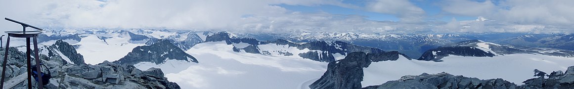 View from the top to west
 -
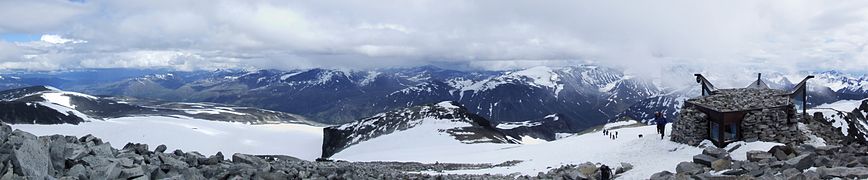 View from the top to east


See also
- List of mountains in Norway by height
- Extreme points of Norway
- List of mountain peaks by prominence
- List of European ultra-prominent peaks
- Scandinavian mountain range
References
Notes
- ^ a b c d "Galdhøpiggen". PeakVisor.com. Retrieved 8 May 2022.
- ^ a b "Europe Ultra Prominences". Peaklist.org. Retrieved 17 February 2013.
- ^ "Top 100 Mountains in Scandinavia ranked by primary factor".
- ^ "Galdhøpiggen, Lom" (in Norwegian). yr.no. Retrieved 8 May 2022.
- ^ a b "Galdhøpiggen Hiking Guide (Multiple Hiking Options + Tips) - The Norway Guide". 18 July 2022. Retrieved 19 August 2022.
- ^ "Galdhøpiggen Summer Ski Centre". Archived from the original on 27 April 2009.
Sources
- Dyer, Anthony; Baddeley, John; Robertson, Ian H. (2006). Walks and Scrambles in Norway. Rockbuy Limited. ISBN 9781904466253.
- Pollmann, Bernhard (2000). Norway South: Rother Walking Guide. Bergverlag Rudolf Rother. ISBN 9783763348077.
External links
 Media related to Galdhøpiggen at Wikimedia Commons
- Galdhøpiggen
- "Galdhøpiggen, Norway" on Peakbagger
- Galdhøpiggen
- Droner i naturen skaper reaksjoner: – Mange driter i at det er forbud (18 June 2021) NRK
- Juvasshytta (in Norwegian)
- Computer generated summit panoramas North South Index
| International | |
|---|---|
| National | |