Gamigaya Petroglyphs
Gəmiqaya petroqlifləri | |
| . | |
| Beginning date | 4th-1st millennia BC |
|---|---|
Gamigaya rock carvings (

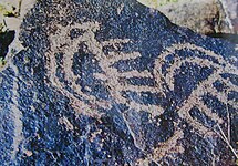
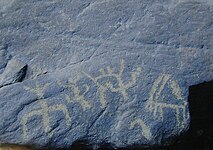
Gamigaya (stone ship) – is the name of Gapyjiq summit (3906) - one of the summits of the Lesser Caucasus, where according to a local legend during a flood myth Noah's Ark pulled in to and turned to a stone in due course. There have been found about 1500 punched out and carved rock images of deer, goats, bulls, dogs, snakes, birds, fantastic beings, and also people, carriages and various symbols. Chaotically drawn images of dancing people can be also met among the images.[3]
Many of these images were fixed not far from springs, in the territory of Garangush plateau. Images of people were carved schematically. Single, pair and group images can also be found there. A person's image near a horse is considered one of the unique ones.[4]
Images of goats pointing to that, goats took a main place in cattle-breeding life of local population. On one of the rocks a painter portrayed a stressed leopard. Realistic drawings of deer are also very interesting.[5]
Beside the Garangush flat, there are rock carvings in Nabiyurdy and Jamishoglan territories.
Topographical positions of drawings are complicated.[7] Drawings that are in group shape are mainly located near the water resources. Such drawings are observed in the northeast of Dali bulag. Far from these sources, drawings are observed less.[8]
A collection of Gamigaya petroglyphs, especially the ones nearby Bibgatal worship place, proves that they do not only illustrate people's semi-nomadic lifestyle, but also the beliefs of ancient humans.[8] For instance, there are pictures of a person and moon and sun above him shows the astrological beliefs and religious-ideological views of ancient people. Those pictures date back to IV-I millenniums B.C.[11]
Beside the pictures of animals, dancing people, and hunting people, there were found pictographic signs such as circles, triangles, rectangles, and fortune symbols. Those sings were found in I Kultapa, on the surface of clay plaque, which belongs to Bronze Age.[12][13]
History
Due to tough climate and heavy rains, approximately 150 settlements were buried under water in Kura-Aras lowlands. For that reason, people who lived in that territory moved to the mountains in west, where they put the foundation of Gamigaya rock art culture.[14]
Expeditions
The investigation of Gamigaya petroglyphs started in 1968.[15] During 1970–1987, 2001–2002, and afterwards, A. Seyidov, N. Museyibli, V. Aliyev, and V. Bakhshaliyev conducted archaeological expeditions.[11] On 26 April 2001, Supreme Council of Nakhchivan Autonomous Republic passed an order on “Research of Gamigaya monument in Ordubad district”. After the order, the number of archaeological expeditions increased.[12] [16] New Gamigaya petroglyphs were found in 2008.[11]
Gallery
See also
References
- ^ "Наскальная живопись Гямигая" (PDF). irs-az.com.
- ^ CULTURE OF AZERBAIJAN. Administrative Department of the President of the Republic of Azerbaijan.
- ^ "Nakhchivan has made valuable gifts to world world civilization".
- ^ "Гямигая". Archived from the original on 2013-02-09.
- ^ "Topography of Gamigaya drawings and a legend of NUH". Archived from the original on 2016-03-03. Retrieved 2012-03-05.
- ^ "City and regions". imp.nakhchivan.az. Retrieved 2018-09-13.
- ^ a b Prehistórico, Caminos de Arte Rupestre. "GAMI-GAYA ROCK OF NAKHCHIVAN". www.prehistour.eu. Retrieved 2018-09-13.
- ^ a b c "Gemigaia Rock-Art, Ordubad region, AZERBAIJAN - Med-O-Med". Med-O-Med. Retrieved 2018-09-13.
- ^ Karimov, Emil. (2014). Nakhchivan - an Ethnographic Phenomenon.
- ^ "The subject,essence and content of a course «Service Economy»". Archived from the original on 2018-09-13. Retrieved 2018-09-13.
- ^ a b c Khalilov, Togrul (2017). GAMİKAYA ÇEVRESİNDEN BULUNMUŞ YENİ KAYAÜSTÜ RESİMLERİN BAZILARI HAKKINDA. Archived 2017-10-30 at the Wayback Machine (in Turkish) AVRASYA Uluslararası Araştırmalar Dergisi.
- ^ ISBN 5-8066-1468-9.
- ^ The Encyclopedia of Nakhchivan Monuments[permanent dead link] (2008). National Academy of Sciences of Azerbaijan Nakhchivan Branch.
- ^ Imat, Fatih; Bababeyli, Nazim; Ozdemir, Mustafa; Yaung, Myungga (2012). "ABOUT SIMILAR FEATURES AND MOTIVES OF KARS-KAĞIZMAN (TURKEY), GEMİKAYA (AZERBAIJAN), ULSAN (SOUTH KOREA) AND ALTA (NORWAY) ROCK PETROGLIFES". Journal of World of Turks. 4.
- ^ "Azerbaijan: Discovering Archeological Monuments Of Nakhchivan – OpEd". Eurasia Review. 2015-08-11. Archived from the original on 2018-09-14. Retrieved 2018-09-14.
- ISBN 1365015793.


