
Gauḍa (city)
Rajshahi division (in Bangladesh) | |
| Coordinates | 24°52′0″N 88°8′0″E / 24.86667°N 88.13333°E |
|---|---|
| Type | Settlement |
| Length | 7 1/8 km |
| Width | 1–2 km |
| History | |
| Founded | 7th century |
| Abandoned | 16th century |
Gauḍa (also known as Gaur, Gour,
For a period of 112 years, between 1453 and 1565, Gauda was the capital of the Bengal Sultanate. In 1500, Gauda was the fifth-most populous city in the world, with a population of 200,000,[4][5] as well as one of the most densely populated cities in the Indian subcontinent. The Portuguese left detailed accounts of the city. The Sultans built a citadel, many mosques, a royal palace, canals and bridges. Buildings featured glazed tiles.
The city thrived until the collapse of the Bengal Sultanate in the 16th century, when the Mughal Empire took control of the region. When the Mughal Emperor Humayun invaded the region, he renamed the city Jannatabad ("heavenly city"). Most of the surviving structures in Gauda are from the period of the Bengal Sultanate. The city was sacked by Sher Shah Suri. An outbreak of the plague contributed to the city's downfall. The course of the Ganges was once located near the city, but a change in the river's course caused Gauda to lose its strategic importance. A new Mughal capital developed later in Rajmahal and then in Dhaka.
Gauda was one of the most prominent capitals in the
Geography


5miles
River
River
checkpoint
Suzapur
M: municipal town, CT: census town, R: rural/ urban centre, F: Facility, H: historical centre
Owing to space constraints in the small map, the actual locations in a larger map may vary slightly
Location
Gauḍa is located at 24°52′N 88°08′E / 24.867°N 88.133°E. It straddles the
History
Kingdom of Gauda
After the fall of the Gupta Empire, western Bengal was ruled by the Gauda Kingdom and eastern Bengal by the Samatata Kingdom. Gauda was founded by Shashanka, one of the pioneering Bengal kings in history.[7] Shashanka's reign falls approximately between 590 and 625.
Pala Empire

The
Sena kingdom
Gauda became known as Lakhnauti during the Sena dynasty. The name was in honour of the Sena ruler Lakhsman Sena.[10]
Sultanate period
Delhi Sultanate
On a
Independent Lakhnauti
In 1281,
Bengal Sultanate


Gauda was widely known as Gaur during the Bengal Sultanate. The founder of the sultanate, Shamsuddin Ilyas Shah, was Delhi's governor in Satgaon. Ilyas Shah rebelled and overthrew Gaur's governor Alauddin Ali Shah in 1342. Ilyas Shah united the Bengal region into a separate independent state from Delhi in 1352. Pandua became the first capital of the sultanate. In 1450, Sultan Mahmud Shah of Bengal announced the transfer of Bengal's capital from Pandua to Gaur. The transfer was completed by 1453. Gaur served as the Bengali sultanate's capital for over one hundred years until 1565.
Gaur was one of the most densely populated cities in the Indian subcontinent, with a population rivalling that of
The Portuguese historian Castenhada de Lopez described the houses of Gaur. Most buildings were one-storeyed with ornamental floor tiles,
In the 16th-century, Gaur was occupied by the Mughal emperor Humayun who sought to name it as Jannatabad (heavenly city).[11] The city was looted and plundered during Sher Shah Suri's invasion. After 1565, Sultan Sulaiman Khan Karrani shifted the capital to Tandah. In 1575, Gaur was conquered by a Mughal contingent led by Munim Khan. The Bengal Sultanate ended during the Battle of Rajmahal in 1576.
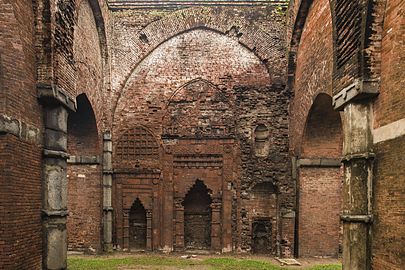
- Structures and ruins of the Bengal Sultanate
-
 Ruins at the ancient city of Gour, 1795
 -
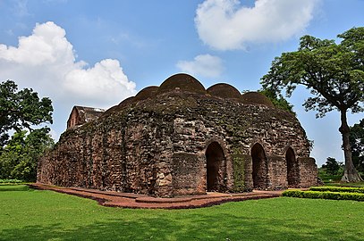
 Darasbari Mosque
 -
 Chamkan Mosque
 -
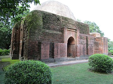
 Khania Dighi Mosque
 -
 Dhani Chowk Mosque
 -
 Tantipara Mosque
 -
 Arabesque and terracotta
 -
 Gunmant Mosque
 -
 Chamkati Mosque
 -
 Do-chala tomb
 -
 Fading enamelled bricks on Gumti Gate
 -
 Gravestones resembling theTomb of Cyrus
 -
 Baisgazi Wall (city wall)


Mughal period
The Mughals built several structures in Gaur. The two-storeyed Mughal Tahakhana complex was a resting place for viceroys. The tahkhana in Persian means a building with a cool environment.[12] The name indicates that the complex had an indoor ventilation system to moderate humid temperatures. The complex was also used as a Sufi khanqah.[12] The Lukochori Darwaza (hide and seek gate) was erected on the road that led to the complex. The construction of these structures can be traced to the reign of viceroy Shah Shuja.[11] An outbreak of the plague and a change in the course of the Ganges caused the city to be abandoned. Since then the area has been a heap of ruins in the wilderness and almost overgrown with jungle.[13]
Abandonment
The great river of Ganges was conventionally linked with the Baghirhati-Hooghly river, but after the late 16th century the river linked up with Padma as its primary channel and abandoned its channels in the south-western portion of the Bengal Delta. Venetian traveller Cesare Federici observed that ships were unable to sail north of Saptagram for this very reason.
Around the same time the Ganges silted up and abandoned its channels above Gauda, the city only recently having been captured by Mughal forces suffered a devastating epidemic and was consequentially abandoned.[14]
- Mughal structures of Gaur
-
 Hide and Seek Doorway
 -

-
 Mughal viceregal lodge
 -
 Mughal Sufi shrine


Historical measurements and statistics
_(BM).JPG)
_(BM).JPG)
The city in its prime measured 7+1⁄8 km (4.4 mi). from north to south, with a breadth of 1 to 2 km (0.62 to 1.24 mi). With suburbs it covered an area of 20 to 30 km (12 to 19 mi), and in the 16th century the Portuguese historian
Fergusson in his History of Eastern Architecture thus describes the general architectural style of Gauḍa:
It is neither like that of Delhi nor Jaunpur, nor any other style, but one purely local and not without considerable merit in itself; its principal characteristic being heavy short pillars of stone supporting pointed arches and vaults in brick whereas at Jaunpore, for instance, light pillars carried horizontal architraves and flat ceilings. Owing to the lightness of the small, thin bricks, which were chiefly used in the making of Gauḍa, its buildings have not well withstood the ravages of time and the weather; while much of its enamelled work has been removed for the ornamentation of the surrounding cities of more modern origin. Moreover, the ruins long served as a quarry for the builders of neighbouring towns and villages, till in 1900 steps were taken for their preservation by the government. The finest ruin in Gauḍa is that of the Great Golden Mosque, also called Bara Darwaza, or twelve doored (1526). An arched corridor running along the whole front of the original building is the principal portion now standing. There are eleven arches on either side of the corridor and one at each end of it, from which the mosque probably obtained its name. These arches are surmounted by eleven domes in fair preservation; the mosque had originally thirty-three.[16]
Notable structures

According to
Preservation
.jpg)
The Archaeological Survey of India and the Department of Archaeology in Bangladesh are responsible for preserving heritage structures in the area. The Bangladeshi Archaeology Department has carried out several projects in both the Bangladeshi and Indian sides of Gauda.[11]
The Indian archaeological survey is also carrying out excavations of a mound about a kilometre from the Chikha building within the Baisgaji Wall where remains of a palace are turning up. A permanent artefact and photographic exhibition highlighting the major monuments of Gour and the restoration work is undertaken by the ASI is being held at the Metcalfe Hall, Kolkata. Among the exhibits are also some fine specimens of brick moulding and glazed tiles from Gour.[citation needed]
Transport
Bus and rail transport are available from Kolkata to Malda town. The nearest railway station is Gour Malda. Although, it is desirable to visit Gauda via Malda Town railway station. Gauda can be accessed through the Sonamosjid checkpoint on the Bangladesh-India border. The checkpoint is located near the Choto Sona Mosque in Chapai Nawabganj district, Bangladesh.[17]
Notes
- ^ "Baynes, T. S.; Smith, W. R., eds. (1880). . Encyclopædia Britannica. Vol. 11 (9th ed.). New York: Charles Scribner's Sons. p. 113.
- ISBN 978-81-208-0690-0.
Thus Gauda flourished as an important city of Eastern India for a considerable period of time before the establishment of Muslim rule, and pre-Muslim rulers of the country often built new cities named after them in the vicinity of the site.
- S2CID 41787985.)
{{cite journal}}: CS1 maint: multiple names: authors list (link - ^ "Bar chart race: the most populous cities through time". Archived from the original on 21 December 2021 – via www.youtube.com.
- ^ Kapadia, Aparna. "Gujarat's medieval cities were once the biggest in the world – as a viral video reminds us". Scroll.in.
- ^ Safvi, Rana (2 March 2019). "Once upon a fort: Gaur's Firoz Minar is still an imposing sight". The Hindu – via www.thehindu.com.
- ^ "Shashanka". Banglapedia.
- ISBN 978-81-208-1250-5.
- ^ "gaudiya -- the Bengalis". Sanskrit Dictionary.
- ^ "Lakhnauti". Banglapedia.
- ^ a b c d e "Gaur, City". Banglapedia.
- ^ a b "Tahkhana Complex". Banglapedia.
- ^ Chisholm 1911, pp. 534–535.
- ISBN 9780520205079.
- ^ "frieze | British Museum". The British Museum.
- ^ a b Chisholm 1911, p. 535.
- ^ "Land Ports in a Brief" (DOC). Bangladesh Trade Portal.
References
- This article incorporates text from a publication now in the public domain: Chisholm, Hugh, ed. (1911). "Gaur". Encyclopædia Britannica. Vol. 11 (11th ed.). Cambridge University Press. pp. 534–535. endnotes:
- M. Martin (Buchanan Hamilton), Eastern India, vol. iii. (1831);
- G. H. Ravenshaw, Gaur (1878);
- James Fergusson, History of Indian and Eastern Architecture (1876);
- Reports of the Archaeological Surveyor, Bengal Circle (1900–1904).
External links
- Gaur at Banglapedia
 Gour-Pandua travel guide from Wikivoyage
- Gaud travel guide from Wikivoyage
| Part of a series on the |
| Bengal Sultanate |
|---|
 |
Cities, towns and locations in Malda district, Malda division | ||||||
|---|---|---|---|---|---|---|
| Cities, municipal and census towns |
|  | ||||
| Locations other than cities and towns |
| |||||
| Neighbourhood | ||||||
| Related topics | ||||||