Gavdos
Gavdos
Γαύδος | |
|---|---|
UTC+3 (EEST) | |
| Postal code | 730 01 |
| Area code(s) | 28230 |
| Vehicle registration | ΧΝ |
Gavdos (
Name
Gavdos has been known by a wide variety of names. For example, it appears in the biblical account of Paul's journey to Rome in Acts 27 as "Clauda" (Κλαῦδα) or "Cauda" (Καῦδα). The island was also referred to as "Cauda" by Roman geographer Pomponius Mela, and as "Gaudos" by Pliny. Ptolemy called Gavdos "Claudos" (Κλαῦδος).[2] The Venetians called it "Gotzo", perhaps in imitation of the Maltese island "Gozo".[3] From the 17th to the 19th centuries, the island was known as "Gondzo". A Turkish name of Godzo was "Bougadoz".

Geography
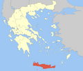
The island is 26 nautical miles (48 km) south of
Environment
There is an islet called

Climate
Gavdos is the southernmost island in
| Climate data for Gavdos 25 m a.s.l. (2016–2024) | |||||||||||||
|---|---|---|---|---|---|---|---|---|---|---|---|---|---|
| Month | Jan | Feb | Mar | Apr | May | Jun | Jul | Aug | Sep | Oct | Nov | Dec | Year |
| Record high °C (°F) | 20.2 (68.4) |
19.8 (67.6) |
22.2 (72.0) |
27.2 (81.0) |
36.3 (97.3) |
41.5 (106.7) |
43.2 (109.8) |
39.8 (103.6) |
34.9 (94.8) |
32.3 (90.1) |
27.1 (80.8) |
22.1 (71.8) |
43.2 (109.8) |
| Mean daily maximum °C (°F) | 15.9 (60.6) |
16.3 (61.3) |
17.9 (64.2) |
19.5 (67.1) |
24.1 (75.4) |
28.5 (83.3) |
32.2 (90.0) |
32.5 (90.5) |
29.1 (84.4) |
25.1 (77.2) |
21.2 (70.2) |
17.8 (64.0) |
23.3 (74.0) |
| Daily mean °C (°F) | 13.6 (56.5) |
14.0 (57.2) |
15.3 (59.5) |
16.7 (62.1) |
20.9 (69.6) |
24.8 (76.6) |
28.2 (82.8) |
28.7 (83.7) |
25.9 (78.6) |
22.4 (72.3) |
19.1 (66.4) |
15.5 (59.9) |
20.4 (68.8) |
| Mean daily minimum °C (°F) | 11.3 (52.3) |
11.6 (52.9) |
12.6 (54.7) |
14.0 (57.2) |
17.6 (63.7) |
21.1 (70.0) |
24.2 (75.6) |
24.9 (76.8) |
22.7 (72.9) |
19.7 (67.5) |
17.0 (62.6) |
13.2 (55.8) |
17.5 (63.5) |
| Record low °C (°F) | 3.9 (39.0) |
7.3 (45.1) |
7.7 (45.9) |
8.7 (47.7) |
13.1 (55.6) |
16.6 (61.9) |
21.6 (70.9) |
21.7 (71.1) |
19.2 (66.6) |
14.7 (58.5) |
10.0 (50.0) |
6.4 (43.5) |
3.9 (39.0) |
| Average rainfall mm (inches) | 79.2 (3.12) |
42.2 (1.66) |
50.2 (1.98) |
14.4 (0.57) |
5.9 (0.23) |
10.5 (0.41) |
0.0 (0.0) |
0.04 (0.00) |
22.2 (0.87) |
58.3 (2.30) |
46.8 (1.84) |
64.4 (2.54) |
394.14 (15.52) |
| Source: Creta Weather Davis station (Sep 2016 – Feb 2024)[11] | |||||||||||||
Demographics
There are only a small number of year-round residents of Gavdos and services for tourists are basic. As of 2021[update], the resident population of Gavdos was 142.[1] In the summer the total people on the island can reach over 3,500, most of whom are campers and tourists. The largest man-made harbour is at Karave. The island's capital is Kastri. The southernmost populated village is Vatsiana, with a total permanent population of 31 people. Fokia (with Korfos beach area), Ampelos and the area around Sarakiniko beach are the other main populated places.
History

Gavdos has supported a permanent population since Neolithic times and the Bronze Age.[12]
Gavdos has been identified as a possible site of the mythical
Gavdos, under the name of Cauda, was briefly referenced in the Bible's New Testament in the book of Acts. In chapter 27 whilst Paul is a prisoner being transported to Rome by ship they encounter a storm, in verse 16 it reads "As we passed to the lee of a small island called Cauda, we were hardly able to make the lifeboat secure...". (NIV Version) They eventually shipwrecked in Malta.
Gavdos had approximately 8,000 inhabitants by 900 AD. During the
In the 1930s the island was used as a place of exile of
Later on, the general phase of
Economy
There are many abandoned terraces on Gavdos where farmers used to grow crops on the hillsides. There still is some agriculture on Gavdos. During the summer, the population of the island swells to a few thousand because of tourists, although there are few facilities for tourists. There is one year-round cafe in Carave (Karabe) on Gavdos run by Evangelina Tsigonakis.

Transport
. There is a heliport in the northern part of the island. Bus services connect the island's main locations. The island's road network is a mixture of paved, unsurfaced and dirt roads.Politics
Following years of isolation, in 1996 the island came to media prominence. In a NATO exercise Gavdos was the focal point of a confrontation between Greece and Turkey. Following that, Prime Minister Costas Simitis visited Gavdos and announced a five-year, €1.5 million plan for the island's development.
In 2001,
In 2002, the island was in the news again, due to the arrests of members of the extremist
For the first time, a military outpost was established on the Island of Gavdos by the Greek defence ministry on 30 November 2020. The ministry announced plans of doing the same at the Othonoi island, the westernmost point of the country, following the establishment at the southernmost point of Greece. A total of 9 soldiers were deployed at the outpost in Gavdos at the Cape Tripiti. The decision followed the announcement made by the ministry of expanding Greek territorial waters to 12 nautical miles in the Ionian Sea.[16]
Gavdos in literature

Gavdos is featured in
See also
- List of communities of Chania
- List of islands of Greece
- Geography of the Levantine Sea
References
- ^ a b "Αποτελέσματα Απογραφής Πληθυσμού - Κατοικιών 2021, Μόνιμος Πληθυσμός κατά οικισμό" [Results of the 2021 Population - Housing Census, Permanent population by settlement] (in Greek). Hellenic Statistical Authority. 29 March 2024.
- ^ Acts 27:16, Biblos.com parallel bible
- ^ The island of Gavdos, Crete Travel Guide
- ^ "Population & housing census 2001 (incl. area and average elevation)" (PDF) (in Greek). National Statistical Service of Greece. Archived from the original (PDF) on 2015-09-21.
- ^ "Gavdos: The island of the immortals", The World Weekly, 23 October 2014 Archived 11 June 2022 at the Wayback Machine. Retrieved 11 August 2021
- ^ European populations of migratory birds Archived 2011-07-11 at the Wayback Machine, Natural History Museum of Crete of the University of Crete, Flora and Fauna on Gavdos, Gavdos Online Service Archived 2010-03-10 at the Wayback Machine, March 1, 2008.
- ^ "Gavdos and Gavdopoula islands, Crete". BirdLife Data Zone. BirdLife International. 2021. Retrieved 27 February 2021.
- ^ GR181 Gavdos and Gavdopoula islands, Important Areas for the Birds of Greece, Hellenic Ornithological Society, 2007
- ^ "Gavdos, Greece". Tourist Maker. Retrieved 2018-08-29.
- ^ "Solar Sun Hours | Average Daily Solar Insolation | Europe". www.hotspotenergy.com. Retrieved 2018-08-29.
- ^ "Gavdos Creta Weather Davis station". Creta Weather. Retrieved 10 February 2024.
- ^ Kopaka, Katérina (2015). "The Gavdos project. An island culture on the Cretan and Aegean fringe". The European Archaeologist. 46: 62–67.
- ^ "Nazis Pound Crete Allies". Los Angeles Times. June 1, 1941. Retrieved 2007-09-27.
- ^ a b c The Med's 'forgotten' island: It is hard to imagine a more spectacular edge of a continent, John Pickford, BBC News, January 24, 2008.
- ^ Gavdosfm homepage
- ^ "Greece Establishes Military Outposts at the Most Remote Edges of its Territory". Greek Reporter. Retrieved 30 November 2020.
External links
- Gavdos portal – travel guide
- Gavdos harbour-Story (in German)
- The Med's 'forgotten' island (BBC) (in English)

