
Gazipaşa
This article needs additional citations for verification. (June 2010) |
Gazipaşa | |
|---|---|
District and municipality | |
 Map showing Gazipaşa District in Antalya Province | |
 Gazipaşa Location in Turkey | |
| Coordinates: 36°16′22″N 32°18′47″E / 36.27278°N 32.31306°E | |
| Country | Turkey |
| Province | Antalya |
| Government | |
| • Mayor | Mehmet Ali Yılmaz (CHP) |
| Area | 1,111 km2 (429 sq mi) |
| Population (2022)[1] | 53,702 |
| • Density | 48/km2 (130/sq mi) |
| Time zone | UTC+3 (TRT) |
| Postal code | 07900 |
| Area code | 0242 |
| Website | www |
Gazipaşa (Turkish pronunciation:
Geography
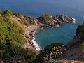
The district of Gazipaşa stands on a narrow strip of coast between the Mediterranean Sea and the high Taurus Mountains rising steeply behind (highest point the 2253m "Deliktaş". Prehistoric animal remains (shelled sea animals) can be found at many locations in the mountains. Before these were the Taurus Mountains (Paleozoic Age) these peaks were below the sea. The coast road is winding Alanya, but good with four lanes in places making Gazipaşa easy to access from Antalya and Alanya. From Gazipaşa east the road is two lanes but in the process of being improved to four. It is 80 km to the next town Anamur which takes two hours to drive). The remote rocky hillsides are home to snakes, scorpions and other wildlife such as deer, rabbits, wild boar, wild sheep and badgers. There is 50 km of coastline, half of which is sandy beach and rocky stretches with small coves that can be used for swimming. The beaches of Gazipaşa are used as nesting grounds by loggerhead sea turtles. Construction is forbidden in these sea turtle areas.
The local economy depends on agriculture and the land of the coastal strip is used for growing fruits and vegetables, especially citrus fruits and bananas. The mountainous areas have many fruit orchards and in recent years a large number of glasshouses have been built to produce crops such as cucumbers, strawberries and artichokes all year round in both locations. Some grain is grown and there is also much animal husbandry animals in the summer these animals are grazed higher in the mountains. Gazipasa has a dam (Gökçeler Barajı). There is also some forestry and fishing but only small industry. Its current mayor is Mehmet Ali Yılmaz.
Gazipaşa has not experienced the tourist boom of neighbouring Alanya but there are now[when?] efforts being made to attract tourists to the district by building a yacht marina and an international airport. Tourist attractions include some sites from antiquity, caves, beaches, the opportunity to appreciate the marvellous Taurus Mountain scenery with mountain walking or motor touring.
The
.Climate
Finike has a
with very hot, dry summers, and mild winters with heavy rain.| Climate data for Gazipaşa (1991–2020) | |||||||||||||
|---|---|---|---|---|---|---|---|---|---|---|---|---|---|
| Month | Jan | Feb | Mar | Apr | May | Jun | Jul | Aug | Sep | Oct | Nov | Dec | Year |
| Mean daily maximum °C (°F) | 16.1 (61.0) |
16.5 (61.7) |
18.5 (65.3) |
21.4 (70.5) |
25.3 (77.5) |
29.6 (85.3) |
32.4 (90.3) |
32.8 (91.0) |
30.5 (86.9) |
27.1 (80.8) |
22.1 (71.8) |
17.8 (64.0) |
24.2 (75.6) |
| Daily mean °C (°F) | 11.0 (51.8) |
11.4 (52.5) |
13.4 (56.1) |
16.3 (61.3) |
20.3 (68.5) |
24.6 (76.3) |
27.6 (81.7) |
28.0 (82.4) |
25.2 (77.4) |
21.0 (69.8) |
16.1 (61.0) |
12.5 (54.5) |
19.0 (66.2) |
| Mean daily minimum °C (°F) | 7.1 (44.8) |
7.1 (44.8) |
8.6 (47.5) |
11.2 (52.2) |
15.1 (59.2) |
19.1 (66.4) |
22.2 (72.0) |
22.8 (73.0) |
19.8 (67.6) |
15.7 (60.3) |
11.4 (52.5) |
8.6 (47.5) |
14.1 (57.4) |
| Average precipitation mm (inches) | 176.11 (6.93) |
109.94 (4.33) |
83.54 (3.29) |
40.97 (1.61) |
30.65 (1.21) |
4.12 (0.16) |
1.12 (0.04) |
3.08 (0.12) |
23.33 (0.92) |
83.12 (3.27) |
117.75 (4.64) |
194.59 (7.66) |
868.32 (34.19) |
| Average precipitation days (≥ 1.0 mm) | 11.4 | 8.8 | 7.2 | 4.4 | 3.3 | 2.0 | 1 | 1.2 | 2.3 | 5.1 | 6.5 | 11.0 | 64.2 |
| Average relative humidity (%)
|
64.7 | 64.1 | 66.3 | 68.6 | 68.4 | 64.0 | 62.3 | 63.5 | 62.0 | 61.8 | 62.9 | 66.3 | 64.6 |
| Source: NOAA[5] | |||||||||||||
Composition
There are 53
- Akoluk
- Aydın
- Aydıncık
- Bakılar
- Beyobası
- Beyrebucak
- Çakmak
- Çalıpınar
- Çamlıca
- Çığlık
- Çile
- Çimenbağ
- Çobanlar
- Çörüş
- Cumhuriyet
- Doğanca
- Ekmel
- Esenpınar
- Esentepe
- Gazi
- Göçük
- Gökçebelen
- Gökçesaray
- Güneyköy
- Gürçam
- Hasdere
- Ilıcaköy
- İnalköy
- İnceğiz
- İstiklal
- Kahyalar
- Karaçukur
- Karalar
- Karatepe
- Kırahmetler
- Kızılgüney
- Koru
- Korubaşı
- Küçüklü
- Macarköy
- Muzkent
- Öznurtepe
- Pazarcı
- Şahinler
- Sarıağaç
- Sugözü
- Üçkonak
- Yakacık
- Yeni
- Yenigüney
- Yeniköy
- Yeşilyurt
- Zeytinada
History
This is a part of the world with a long history, and there is evidence of
The later Roman Empire (
Archaeological research continues and in 2004 a team from Florida State University found a small bronze statue of Pegasus dating back to 300 BC in the waters off Gazipaşa; it is now in the Museum of Alanya.
We can list the castles in Gazipaşa as
International relations
Gazipaşa is
Gallery of various scenes
-
 Ruins
Ruins -
 More ruins
 -
 Even more ruins
 -
 Yet more ruins
 -
 Roman aqueduct ruins
 -
 Roman graves
 -
 Emerald Lagoon
 -
-
 A coastal restaurant
 -
 Nationalist Movement Party office
.jpg)
.jpg)


.jpg)


References
- ^ TÜİK. Retrieved 22 May 2023.
- ^ Büyükşehir İlçe Belediyesi, Turkey Civil Administration Departments Inventory. Retrieved 8 June 2023.
- ^ "İl ve İlçe Yüz ölçümleri". General Directorate of Mapping. Retrieved 22 May 2023.
- ^ "Table 1 Overview of the Köppen-Geiger climate classes including the defining criteria". Nature: Scientific Data.
- ^ "World Meteorological Organization Climate Normals for 1991-2020 — Gazipaşa". National Oceanic and Atmospheric Administration. Retrieved January 15, 2024.
- ^ Mahalle, Turkey Civil Administration Departments Inventory. Retrieved 22 May 2023.
External links
- Gazipasa municipality's official website (in Turkish)
- Panorama image
- Investigation of the construction history of the supposed cenotaph of Emperor Trajan (Deutsches Archäologisches Institut)
- Antiochia ad Cragum (University of Nebraska)
- Mitchell, S., R. Talbert, T. Elliott, S. Gillies. "Places: 648772 (Selinous/Traianopolis)". Pleiades. Retrieved March 8, 2012.
{{cite web}}: CS1 maint: multiple names: authors list (link) - Selinos coins
- Gazipaşa news