
Geography of Canada
| Continent | North America |
|---|---|
| Region | Northern America |
| Coordinates | 60°00′N 95°00′W / 60.000°N 95.000°W |
| Area | forest fires |
| Environmental issues | air and water pollution, acid rains |
| Exclusive economic zone | 5,599,077 km2 (2,161,816 sq mi) |
Canada is home to the world's northernmost settlement,
Canada can be divided into seven physiographic regions: the
Canada is geologically active, having many earthquakes and potentially active volcanoes, notably the Mount Meager massif, Mount Garibaldi, Mount Cayley, and the Mount Edziza volcanic complex.[19] Average winter and summer high temperatures across Canada range from Arctic weather in the north, to hot summers in the southern regions, with four distinct seasons.
Physiography
Canada covers 9,984,670 km2 (3,855,100 sq mi) and a panoply of various geoclimatic regions, of which there are seven main regions.
The National Topographic System is used by Natural Resources Canada for providing general purpose topographic maps of the country. The maps provide details on landforms and terrain, lakes and rivers, forested areas, administrative zones, populated areas, roads and railways, as well as other man-made features.[22] These maps are used by all levels of government and industry for forest fire and flood control (as well as other environmental issues), depiction of crop areas, right-of-way, real estate planning, development of natural resources and highway planning.[22]
Appalachian Mountains
The Appalachian mountain range extends from Alabama in southern United States through the Gaspé Peninsula and the Atlantic Provinces, creating rolling hills indented by river valleys.[23] It also runs through parts of southern Quebec.[23]
The Appalachian Mountains (more specifically the
Great Lakes and St. Lawrence Lowlands

The
The St. Lawrence Lowlands is one of the most densely populated, prosperous and productive regions in
Canadian Shield

The northeastern part of
The Shield cannot support intensive agriculture, although there is subsistence agriculture and small dairy farms in many of the river valleys and around the abundant lakes, particularly in the southern regions.
The Canadian Shield is known for its vast mineral reserves such as emeralds, diamonds and copper, and is there also called the "mineral house".[27]
Canadian Interior Plains
The
Canadian Arctic
While the largest part of the Canadian Arctic is composed of seemingly endless
The Arctic, when defined as everything north of the tree line, covers most of Nunavut and the northernmost parts of Northwest Territories, Yukon, Manitoba, Ontario, Quebec and Labrador. The archipelago consists of 36,563 islands, of which 94 are classified as major islands, being larger than 130 km2 (50 sq mi), and cover a total area of 1,400,000 km2 (540,000 sq mi).[36]
Western Cordillera

The Coast Mountains in British Columbia run from the lower Fraser River and the Fraser Canyon northwestward, separating the Interior Plateau from the Pacific Ocean.[37] Its southeastern end is separated from the North Cascades by the Fraser Lowland, where nearly a third of Western Canada's population reside.
The coastal flank of the Coast Mountains is characterized by an intense network of
The terrain of the main spine of the Coast Mountains is typified by heavy
The Coast Mountains are made of
The Insular Mountains extend from Vancouver Island in the south to the Haida Gwaii in the north on the British Columbia Coast. It contains two main mountain ranges, the Vancouver Island Ranges on Vancouver Island and the Queen Charlotte Mountains on Haida Gwaii.[39]
Hudson Bay Lowlands

The
Extreme points

The northernmost point of land within the boundaries of Canada is
The westernmost point is
The Canadian pole of inaccessibility is allegedly near Jackfish River, Alberta (59°2′N 112°49′W).[49] The furthest straight-line distance that can be travelled to Canadian points of land is between the southwest tip of Kluane National Park and Reserve (next to Mount Saint Elias) and Cripple Cove, Newfoundland (near Cape Race) at a distance of 3,005.60 nautical miles (5,566.37 km; 3,458.78 mi).
Climatology

Climate varies widely from region to region. Winters can be harsh in many parts of the country, particularly in the interior and Prairie provinces, which experience a continental climate, where daily average temperatures are near −15 °C (5 °F), but can drop below −40 °C (−40 °F) with severe wind chills.[50] In non-coastal regions, snow can cover the ground for almost six months of the year, while in parts of the north snow can persist year-round. Coastal British Columbia has a temperate climate, with a mild and rainy winter. On the east and west coasts, average high temperatures are generally in the low 20s °C (70s °F), while between the coasts, the average summer high temperature ranges from 25 to 30 °C (77 to 86 °F), with temperatures in some interior locations occasionally exceeding 40 °C (104 °F).[51]
Much of Northern Canada is covered by ice and permafrost; however, the future of the permafrost is uncertain because the Arctic has been warming at three times the global average as a result of climate change in Canada.[52] Canada's annual average temperature over land has warmed by 1.7 °C (3.1 °F), with changes ranging from 1.1 to 2.3 °C (2.0 to 4.1 °F) in various regions, since 1948.[53] The rate of warming has been higher across the North and in the Prairies.[53] In the southern regions of Canada, air pollution from both Canada and the United States—caused by metal smelting, burning coal to power utilities, and vehicle emissions—has resulted in acid rain, which has severely impacted waterways, forest growth and agricultural productivity in Canada.[54]
Biogeography

Canada's major biomes are the
Over half of Canada's landscape is intact and relatively free of human development.
Approximately 12.1 percent of the nation's landmass and freshwater are conservation areas, including 11.4 percent designated as protected areas.[18] Approximately 13.8 percent of its territorial waters are conserved, including 8.9 percent designated as protected areas.[18]
Palaeogeography

Volcanic activity is a major part of the geology of Canada and is characterized by many types of volcanic landform, including lava flows, volcanic plateaus, lava domes, cinder cones, stratovolcanoes, shield volcanoes, submarine volcanoes, calderas, diatremes, and maars, along with less common volcanic forms such as tuyas and subglacial mounds.
Though
Hydrography

Canada holds vast reserves of water: its rivers discharge nearly 7% of the world's renewable water supply,
The Atlantic watershed drains the entirety of the

The
The
The northern parts of Alberta, Manitoba, and British Columbia, most of Northwest Territories and Nunavut, and parts of Yukon are drained by the Arctic watershed. This watershed has been little used for hydroelectricity, with the exception of the Mackenzie River. The
The southernmost part of Alberta drains into the Gulf of Mexico through the Milk River and its tributaries. The Milk River originates in the Rocky Mountains of Montana, then flows into Alberta, then returns into the United States, where it is drained by the Missouri River. A small area of southwestern Saskatchewan is drained by Battle Creek, which empties into the Milk River.[70]
Natural resources
Canada's abundance of natural resources is reflected in their continued importance in the economy of Canada. Major resource-based industries are fisheries, forestry, agriculture, petroleum products and mining.[71]
The fisheries industry has historically been one of Canada's strongest. Unmatched
Five per cent of Canada's land area is arable, none of which is for permanent crops. Three per cent of Canada's land area is covered by permanent pastures. Canada has 7,200 square kilometres (2,800 sq mi) of irrigated land (1993 estimate). Agricultural regions in Canada include the Canadian Prairies, the

Fossil fuels are a more recently developed resource in Canada, with
Canada's mineral resources are diverse and extensive. Across the Canadian Shield and in the north there are large iron, nickel, zinc, copper, gold, lead, molybdenum, and uranium reserves. Large diamond concentrations have been recently developed in the Arctic, making Canada one of the world's largest producers. Throughout the Shield there are many mining towns extracting these minerals. The largest, and best known, is Sudbury, Ontario. Sudbury is an exception to the normal process of forming minerals in the Shield since there is significant evidence that the Sudbury Basin is an ancient meteorite impact crater. The nearby, but less known Temagami Magnetic Anomaly has striking similarities to the Sudbury Basin. Its magnetic anomalies are very similar to the Sudbury Basin, and so it could be a second metal-rich impact crater.[72] The Shield is also covered by vast boreal forests that support an important logging industry.
Canada's many rivers have afforded extensive development of hydroelectric power. Extensively developed in British Columbia, Ontario, Quebec and Labrador, the many dams have long provided a clean, dependable source of energy.
Environmental issues

Air pollution and resulting acid rain severely affects lakes and damages forests.[54] Metal smelting, coal-burning utilities, and vehicle emissions impact agricultural and forest productivity. Ocean waters are also becoming contaminated by agricultural, industrial, mining, and forestry activities.[54]
Global climate change and the warming of the polar region will likely cause significant changes to the environment, including loss of the polar bear,[73] the exploration for resource then the extraction of these resources and an alternative transport route to the Panama Canal through the Northwest Passage.
Canada is currently warming at twice the global average, and this is effectively irreversible.[74]
Political geography
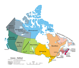
Canada is divided into ten provinces and three territories. According to Statistics Canada, 72.0 percent of the population is concentrated within 150 kilometres (93 mi) of the nation's southern border with the United States, 70.0% live south of the 49th parallel, and over 60 percent of the population lives along the Great Lakes and St. Lawrence River between Windsor, Ontario, and Quebec City. This leaves the vast majority of Canada's territory as sparsely populated wilderness; Canada's population density is 3.5 people per square kilometre (9.1 people/sq mi), among the lowest in the world. Despite this, 79.7 percent of Canada's population resides in urban areas, where population densities are increasing.[75]
Canada shares with the U.S. the world's
Canada's geographic proximity to the United States has historically bound the two countries together in the political world as well. Canada's position between the
See also

- Atlas of Canada
- Canadian Geographic
- Canadian Rockies
- Extreme points of North America
- List of highest points of Canadian provinces and territories
- National Parks of Canada
- List of Ultras of Canada
- Mountain peaks of Canada
- Temperature in Canada
 Canada portal
References
- ^ "Canada". The World Factbook (2024 ed.). Central Intelligence Agency. Retrieved 23 May 2011. (Archived 2011 edition.)
- ISBN 978-1-317-48718-0. Archivedfrom the original on 20 March 2018.
- ISBN 978-1-4269-3393-6. Archivedfrom the original on 12 April 2016.
- ^ Canadian Geographic. Royal Canadian Geographical Society. 2008. p. 20.
- ISSN 0261-3077. Retrieved 2 July 2019.
- ^ "Geography". statcan.gc.ca. Archived from the original on 7 March 2016. Retrieved 4 March 2016.
- ^ "The Boundary". International Boundary Commission. 1985. Archived from the original on 1 August 2008. Retrieved 17 May 2012.
- ^ "Canada Facts: 25 Interesting and Fun Facts – not only for Kids". Retrieved 27 June 2018.
- ^ a b Government of Canada, Natural Resources Canada (12 September 2016). "Natural Resources Canada. The Atlas of Canada. Physiographic Regions of Canada". atlas.gc.ca.
- ^ a b Government of Canada, Statistics Canada (10 January 2018). "Introduction to the Ecological Land Classification (ELC) 2017". www.statcan.gc.ca. Retrieved 9 November 2020.
- ^ "COSEWIC Annual Report". Species at Risk Public Registry. 2019.
- ISBN 978-0-7705-1198-2.
- ISBN 978-0-7748-2069-1.
- ISBN 978-0-7735-1672-4. Archivedfrom the original on 12 April 2016.
- ^ "The Atlas of Canada – Physical Components of Watersheds". 5 December 2012. Archived from the original on 5 December 2012. Retrieved 4 March 2016.
- ISBN 978-1-927330-20-3. Archivedfrom the original on 3 July 2017.
- S2CID 56481043.
- ^ a b c "Canada's conserved areas". Environment and Climate Canada. 2020.
- ISBN 978-1-4020-1179-5.
- ^ "Geography". www.statcan.gc.ca. Retrieved 4 March 2016.
- ISBN 978-0-8160-5786-3. Retrieved 22 November 2011.
- ^ a b "National Topographic System Maps". www.nrcan.gc.ca. 29 May 2007.
- ^ ISBN 978-0-7614-7289-6. Retrieved 22 November 2011.
- ISBN 978-0-12-397806-6.
- ^ a b c d e f "Physiographic Regions". Natural Resources Canada. 12 September 2016. Retrieved 28 May 2020.
- ^ Encyclopædia Britannica. "Canadian Shield". Archived from the original on 24 June 2015. Retrieved 10 February 2009.
- ^ ISBN 978-0-19-521920-3.
- ISBN 9780968932148.
- ^ McCullough, J.J. "The Prairies". The Canada Guide. Retrieved 8 April 2019.
- ^ "Prairies Ecozone". www.ecozones.ca.
- ^ Chepkemoi, Joyce (25 April 2017). "Facts About the Canadian Prairie Provinces". WorldAtlas. Retrieved 8 April 2019.
- .
- ^ "Prairies Ecozone". Ecological Framework of Canada. Government of Canada. Archived from the original on 2 June 2016.
- ^ "Wide open spaces, but for how long?". The Royal Canadian Geographical Society. The Royal Canadian Geographical Society. 16 October 2014. Archived from the original on 3 April 2016.
- .
- ^ The Canadian Encyclopedia. Toronto: Hurtig Publishers.
- ^ a b c Wilson, Robert J. Geology and Economic Minerals of Canada, p. 26 (Geological Survey of Canada, Department of Energy, Mines and Resources, 1976).
- ^ Rogers, John. A History of the Earth, p. 281 (CUP Archive, November 18, 1993).
- ^ Solski, Ruth. Canadian Provinces & Territories Gr. 4-6, p. 91 (S&S Learning Materials 2003).
- ^ Canadian Encyclopedia - Hudson Bay
- ^ a b Abraham, K.F. and C.J. Keddy. The Hudson Bay Lowland. Pages 118–148 in L.H. Fraser and P.A. Keddy (eds.). 2005. The World's Largest Wetlands: Ecology and Conservation. Cambridge University Press, Cambridge, UK. 488 p.
- ^ Coastal Hudson Bay Lowland ecozone profile
- ^ Hudson Bay Lowland ecozone profile
- ^ James Bay Lowland ecozone profile
- ^ Riley, John L. 2003. Flora of the Hudson Bay Lowland and its Postglacial Origins. NRC Research Press, Ottawa, Canada. 236 p.
- ^ a b c d e f g "Toporama". Atlas of Canada. Natural Resources Canada. 12 September 2016.
- ^ "Canada". The World Factbook (2024 ed.). Central Intelligence Agency. 21 June 2022. (Archived 2022 edition.)
- ^ "141st Meridian Boundary Points". International Boundary Commission. Retrieved 20 December 2010.
- ^ "Jackfish River, Alberta". Natural Resources Canada. Atlas of Canada. Archived from the original on 24 September 2014. Retrieved 10 November 2016.
- ^ "Statistics, Regina SK". The Weather Network. Archived from the original on 5 January 2009. Retrieved 18 January 2010.
- Environment Canada. 25 September 2013. Archivedfrom the original on 18 May 2015. Retrieved 12 May 2015.
- ^ Bush, E; Lemmen, D.S. (2019). "Canada's Changing Climate Report" (PDF). Government of Canada. p. 84. Archived (PDF) from the original on 22 April 2019.
- ^ a b Zhang, X.; Flato, G.; Kirchmeier-Young, M.; et al. (2019). Bush, E.; Lemmen, D.S. (eds.). "Changes in Temperature and Precipitation Across Canada]; Chapter 4" (PDF). Canada's Changing Climate Report. Government of Canada. pp. 112–193. Archived (PDF) from the original on 22 April 2019.
- ^ ISBN 978-0-7748-4063-7.
- ^ "Wild Species 2015: The General Status of Species in Canada" (PDF). National General Status Working Group: 1. Canadian Endangered Species Conservation Council. 2016. p. 2. Archived (PDF) from the original on 9 October 2022.
- ^ Government of Canada, Environment Canada (30 September 2014). "Species at Risk Public Registry - COSEWIC Annual Report 2013-2014". www.sararegistry.gc.ca.
- ISBN 978-0-08-045418-4.
- ^ "State of Canada's Biodiversity Highlighted in New Government Report". 22 October 2010.
- ^ "Total forest coverage by country". The Guardian. 2 September 2009. Retrieved 23 September 2018.
- ISBN 978-0-470-94570-4.
- ISBN 978-0-7710-2099-5.
- ^ "Large Igneous Provinces in Canada Through Time and Their Metallogogenic Potential Appendix 2". Mineral Deposits of Canada. Geological Survey of Canada. 24 September 2008. Archived from the original on 4 June 2011. Retrieved 21 January 2009.
- ^ "Volcanoes". Natural Resources Canada. 5 September 2007. Archived from the original on 17 February 2009. Retrieved 22 January 2009.
- ^ ISBN 0-521-43811-X.
- ^ a b "Regional Metallogeny Large Igneous Provinces in Canada Through Time and Their Metallogenic Potential". Mineral Deposits of Canada. Geological Survey of Canada. 25 September 2008. Archived from the original on 20 April 2010. Retrieved 19 January 2009.
- ^ Atlas of Canada (February 2004). "Distribution of Freshwater". Retrieved 1 February 2007.
- ISBN 92-807-2398-7.
- ISBN 978-0-17-675682-6.
- Environment Canada. 22 July 2013. Retrieved 28 December 2014.
- ^ a b c d e "Drainage Basin". thecanadianencyclopedia. Archived from the original on 8 June 2011. Retrieved 21 February 2008.
- ^ "The Daily — Canada's natural resource wealth, 2021 (preliminary data)". Statistics Canada. 14 November 2022. Retrieved 29 April 2023.
- ^ "3-D Magnetic Imaging using Conjugate Gradients: Temagami anomaly". Geological Survey of Canada. Natural Resources Canada. Archived from the original on 11 July 2009. Retrieved 13 March 2008.
- ^ "The Committee on the Status of Endangered Wildlife in Canada". Government of Canada. Archived from the original on 21 July 2011. Retrieved 7 November 2008.
- ^ "Canada warming up twice as fast as rest of the world, and it's 'irreversible': report". Global News. Retrieved 24 September 2020.
- ^ Canada, Government of Canada, Statistics (15 January 2001). "Population, urban and rural, by province and territory (Canada)". www.statcan.gc.ca. Retrieved 30 January 2018.
{{cite web}}: CS1 maint: multiple names: authors list (link) - ^ Sarkar, Alisha Rahaman (14 June 2022). "That's how to solve an international row: Canada and Denmark agree to split disputed Arctic island". MSN. Retrieved 14 June 2022.
- ^ "Satellite imagery moves Hans Island boundary: report". CBC News. The Canadian Press. 2 July 2007. Retrieved 27 February 2011.
Further reading
- Bailey, William G; Oke, TR; Rouse, Wayne R (1997). The surface climates of Canada. McGill-Queen's University Press. ISBN 0-7735-1672-7.
- Drushka, Ken (2003). Canada's forests: a history. McGill-Queen's University Press. ISBN 0-7735-2660-9.
- Etkin, David; Haque, CE; Brooks, Gregory R (2003). An Assessment of Natural Hazards and Disasters in Canada. Springer. ISBN 978-1-4020-1179-5.
- Feldhamer, George A; Thompson, Bruce Carlyle; Chapman, Joseph A. (2003). Wild mammals of North America (2nd ed.). Johns Hopkins University Press. ISBN 0801874165.
- Fick, Steven (2004). The Canadian atlas: our nation, environment and people. Douglas & McIntyre. ISBN 0888507704.
- French, Hugh M; Slaymaker, Olav (1993). Canada's Cold Environments. McGill-Queen's University Press. ISBN 0-7735-0925-9.
- Hudson, John C (2002). Across this land: a regional geography of the United States and Canada. Johns Hopkins University Press. ISBN 0-8018-6567-0.
- Nils, John Macoun; Kindberg, Conrad (1883). "Catalogue of Canadian plants". Geological Survey of Canada.
{{cite journal}}: Cite journal requires|journal=(help)
External links
- Government of Canada – The Atlas of Canada
- Canadian Geographic – The Canadian Atlas Online
- Cartography of Canada – The Canadian Map Online
- Canada. The World Factbook. Central Intelligence Agency.
| |||||||||||||||||||||
