
Geography of China
 | |
| Continent | Asia |
|---|---|
| Region | East/Southeast Asia |
| Coordinates | 35°0′N 105°0′E / 35.000°N 105.000°E[1] |
| Area | Ranked 4 |
| • Total | 9,596,960[1] km2 (3,705,410 sq mi) |
| • Land | 97.2[1]% |
| • Water | 2.8[1]% |
| Coastline | 14,500[1] km (9,000 mi) |
| Borders | Afghanistan, Bhutan, Burma, India, North Korea, Kazakhstan, Kyrgyzstan, Laos, Mongolia, Nepal, Pakistan, Russia, Tajikistan, Vietnam |
| Highest point | Mount Everest, 8,848 m (29,029 ft)[2] |
| Lowest point | Turpan Pendi, −154 m (−505 ft)[1] |
| Longest river | Yangtze River[3] |
| Largest lake | Qinghai Lake[citation needed] |
| Climate | diverse; ranges from tropical in south to subarctic in north[1] |
| Terrain | mostly mountains, high plateaus, deserts in west and plains, deltas and hills in east[1] |
| Natural resources | coal, iron ore, petroleum, natural gas, mercury, tin, tungsten, antimony, manganese, molybdenum, vanadium, magnetite, aluminum, lead, zinc, rare earth elements, uranium, hydropower potential, arable land[1] |
| Natural hazards | typhoons; damaging floods; tsunamis; earthquakes; droughts; land subsidence[1] |
| Environmental issues | air pollution; water shortages; water pollution; deforestation; soil erosion; desertification; trade in endangered species[1] |

Traditionally, the Chinese population centered on the
The People's Republic of China has an area of about 9,600,000 km2 (3,700,000 sq mi). The exact land area is sometimes challenged by border disputes, most notably about
Physical geography
Generalities

The
Eastern China
- Northeast Plain
Northeast of Shanhaiguan a narrow sliver of flat coastal land opens up into the vast Northeast China Plain. The plains extend north to the crown of the "Chinese rooster", near where the Greater and Lesser Hinggan ranges converge. The Changbai Mountains to the east divide China from the Korean peninsula.
- North plain
The Taihang Mountains form the western side of the triangular North China Plain. The other two sides are the Pacific coast to the east and the Yangtze River to the southwest. The vertices of this triangle are Beijing to the north, Shanghai to the southeast, and Yichang to the southwest. This alluvial plain, fed by the Yellow and Yangtze Rivers, is one of the most heavily populated regions of China. The only mountains in the plain are the Taishan in Shandong and Dabie Mountains of Anhui.
Beijing, at the north tip of the North China Plain, is shielded by the intersection of the Taihang and Yan Mountains. Further north are the drier grasslands of the Inner Mongolian Plateau, traditionally home to pastoralists. To the south are agricultural regions, traditionally home to sedentary populations. The Great Wall of China was built across the mountains that mark the southern edge of the Inner Mongolian Plateau. The Ming-era walls run over 2,000 km (1,200 mi) east to west from Shanhaiguan on the Bohai coast to the Hexi Corridor in Gansu.
- South (hills)
East of the
South of the Yangtze, the landscape is more rugged. Like Shanxi Province to the north, Hunan and Jiangxi each have a provincial core in a river basin that is surrounded by mountains. The Wuling range separates Guizhou from Hunan. The Luoxiao and Jinggang divide Hunan from Jiangxi, which is separated from Fujian by the Wuyi Mountains. The southeast coastal provinces, Zhejiang, Fujian and Guangdong, have rugged coasts, with pockets of lowland and mountainous interior. The Nanling, an east–west mountain range across northern Guangdong, seals off Hunan and Jiangxi from Guangdong.
Xinjiang-Mongolia
Northwest of the Tibetan Plateau, between the northern slope of Kunlun and southern slope of Tian Shan, is the vast
Northeast of the Tibetan Plateau, the
Between the Qinling and the Inner Mongolian Plateau is Loess Plateau, the largest of its kind in the world, covering 650,000 km2 (250,000 sq mi) in Shaanxi, parts of Gansu and Shanxi provinces, and some of Ningxia-Hui Autonomous Region. The plateau is 1,000–1,500m in elevation and is filled with loess, a yellowish, loose soil that travels easily in the wind. Eroded loess silt gives the Yellow River its color and name. The Loess Plateau is bound to the east by the Luliang Mountain of Shanxi, which has a narrow basin running north to south along the Fen River. Further east are the Taihang Mountains of Hebei, the dominant topographical feature of North China.

- Highlands
The
North of the Himalayas and east of the Karakorum/Pamirs is the vast Tibetan Plateau. It is the largest and highest plateau in the world, and for this reason is also informally known as the "Roof of the World". Its average elevation is 4000 meters above sea level. Its area is 2.5 million square kilometers which is just over a quarter of China's total area. In the north, the plateau is hemmed in by the Kunlun Mountains, which extends eastward from the intersection of the Pamirs, Karakorum and Tian Shan.
- Tallest mountain peaks
Besides Mt. Everest and K2, the other 9 of the world's 17 tallest peaks on China's western borders are:
Outside the Himalayas and Karakorum, China's tallest peaks are
Southwestern regions
This section needs expansion. You can help by adding to it. (September 2023) |
Southwestern China is a transition between eastern plains and the high Tibetan plateau; the region is largely mountainous.[5][verification needed]
Rivers

China originally had an estimated number of 50,000 rivers. However, due to statistical discrepancies, water and soil loss, and climate change, there are currently only an estimated 22,000 rivers remaining.

Inland drainage involving upland basins in the north and northeast accounts for 40 percent of the country's total drainage area. Many rivers and streams flow into lakes or diminish in the desert. Some are used for irrigation.
China's territorial waters are principally marginal seas of the western Pacific Ocean. These waters lie on the indented
- Northern plain
There is a steep drop in the river level in the North China Plain, where the river continues across the delta, it transports a heavy load of sand and mud which is deposited on the flat plain. The flow is aided by manmade embankments. As a result, the river flows on a raised ridge fifty meters above the plain. Waterlogging, floods, and course changes have recurred over the centuries. Traditionally, rulers were judged by their concern for or indifference to preservation of the embankments.[citation needed] In the modern era, China has undertaken extensive flood control and conservation measures.
Flowing from its source in the Qingzang highlands, the Yellow River courses toward the sea through the North China Plain, the historic center of Chinese expansion and influence.
Like other densely populated areas of China, the plain is subject to floods and earthquakes. The mining and industrial center of Tangshan, 165 km (103 mi) east of Beijing, was leveled by an earthquake in July 1976, it was believed to be the largest earthquake of the 20th century by death toll.
The
- East and Yangtze
The
The country's longest and most important waterway, the Yangtze River, is navigable for the majority of its length and has a vast
The
Geology and natural resources
China has substantial
potential is the largest in the world.Land use
Based on 2005 estimates, 14.86% (about 1,400,000 km2 (540,000 sq mi)) of China's total land area is
.Deserts
Nearly 20 percent of China (about 1,900,000 km2) is desert:
- Gobi Desert and Hami Desert - 1,295,000 km2 (with Mongolia)
- Dzungaria - 777,000 km2
- Taklamakan Desert - 337,000 km2
- Ordos Desert - 215,952 km2
- Lop Desert - 50,000 km2
- Gurbantünggüt Desert - 50,000 km2
- Mu Us Desert - 48,288 km2
- Badain Jaran Desert - 49,000 km2
- Tengger Desert - 36,700 km2
- Kubuqi Desert - 18,600 km2
- Shapotou, Zhongwei - 5,380 km2
- Kumtag Desert - 2,600 km2
Wildlife
China lies in two of the world's major
Human geography
History

Chinese history is often explained in terms of several strategic areas, defined by particular topographic limits. Starting from the
Demographic geography

The demographic occupation follows the topography and availability of former arable lands. The
Administrative geography
Agriculture
As the country continues to industrialize, the share of agriculture as a part of China's GDP has lowered to 11% in recent years. Of the enormous labor force in China, 27.7% work in agriculture.[9] China's primary agricultural import is wheat from Argentina, Australia, Canada, and France. They import about four to five million metric tons of wheat per year and they are able to buy the wheat for about $700 per ton, making wheat China's most important agricultural import. On the other hand, China's most important agricultural export is rice. China exports about 750,000 metric tons of rice per year for about $1200 per ton.[10] Other significant agricultural exports from China are potatoes, corn, tobacco, peanuts, tea, apples, cotton, pork, mutton, eggs, fish, and shrimp.[9]
According to the World Bank, as of 2015, China's total arable land was estimated at 119,000,000 hectares.[11] Since 2005, arable land in China has been on the decline and the total arable land per citizen has reached .2 acres.[12] As a percentage, agricultural land makes up about 54.7% of land. The climate of the country is difficult to describe because it varies so much depending on the region of China. The southernmost parts of the country are almost tropical, while the northernmost part is subarctic.[13]


Territory and boundary disputes
The territory of China has been defined as a homeland for many different ethnic and racial groups in the country. However, the way that the territory has been defined varies between ethnic groups. In relation to the Han Chinese, the homeland has been defined by national borders which are more or less accepted internationally. This is because the Han Chinese are the largest population and have most influence politically than any other ethnic population in China. To the Han Chinese population, the territory of the country is defined by the regions of Tibet, inner Mongolia, Manchuria, and the Xinjiang Province which is the most western land of China. The Chinese territory is the second largest in land area and also has the longest combined land border in the world. However, there are many other ethnic groups in China that have their own definitions of what concerns the territory of China.
One group of people in China are the Tibetans. Tibetans and the land of Tibet are considered by the Han Chinese government to be part of China and that the territory of Tibet is also part of the country. However, many Tibetans disagree and are protesting as well as rallying for freedom in present day. To this ethnic population, the territory of Tibet is not considered part of China and so is not defined as a Chinese territory. However, the Chinese government still consider Tibet as a territory of China which reflects the dispute in definition of Chinese territory between two ethnic groups.
Another group of people which have a dispute in definition of territory are the Taiwanese. The Taiwanese people inhabit the island of Taiwan and are markedly politically different as the people of Taiwan have a free market capitalist based economy while the mainland Chinese government employ a communistic state run economy. There are disputes in the definition of territory between Taiwan and China as the Chinese government claims ownership over Taiwan while some Taiwanese people maintain that they are a sovereign state completely independent from the mainland Chinese government. These disputes have led to international controversy as many countries such as the United States of America have not officially recognized the sovereignty of Taiwan.[14]
Central Asia
China's borders have more than 20,000 km (12,000 mi) of land frontier shared with nearly all the nations of mainland
Southern border
Eastward from Bhutan and north of the Brahmaputra River (Yarlung Zangbo Jiang) lies a large area controlled and administered by India but claimed by the Chinese. The area was demarcated by the British McMahon Line, drawn along the Himalayas in 1914 as the Sino-Indian border; India accepts and China rejects this boundary. In June 1980 China made its first move in twenty years to settle the border disputes with India, proposing that India cede the Aksai Chin area in Jammu and Kashmir to China in return for China's recognition of the McMahon Line; India did not accept the offer, however, preferring a sector-by-sector approach to the problem. In July 1986 China and India held their seventh round of border talks, but they made little headway toward resolving the dispute. Each side, but primarily India, continued to make allegations of incursions into its territory by the other. Most of the mountainous and militarized boundary with India is still in dispute, but Beijing and New Delhi have committed to begin resolution with discussions on the least disputed middle sector. India does not recognize Pakistan's ceding lands to China in a 1964 boundary agreement.
The China-Burma border issue was settled 1 October 1960, by the signing of the Sino-Burmese Boundary Treaty. The first joint inspection of the border was completed successfully in June 1986.
India: On 15 May 2015, Mr. Li from China and Mr. Modi from India held talks at the Great Hall of the people during Modi's China tour. The two leaders held talks on border disputes that began in 1914 when the British still controlled India and signed an agreement with Tibet to make the McMahon line the de facto boundary between India and China, even though China had rejected this agreement. Both countries had various claims to disputed territories such as the South Tibetan region of Zangnan which is considered to be part of the Arunachal Pradesh state in India. So far there have been only talks and no solutions and tensions continue to rise as each country continues to increase regional influences.[15]
Seas
China is involved in a complex dispute with
South China Sea: On 16 June 2011, the Chinese government sent out one of its largest patrol ships known as the Haixun-31 which the Chinese government describe as routine. The ship will pass the Paracel and Spratly Islands and make its way up from the Malaysian to Filipino coast. Vietnam, China, the Philippines, Taiwan, Brunei and Malaysia all have competing claims to the Spratlys Islands while Beijing and Hanoi are in dispute over the Paracel islands. Hanoi has proposed a multilateral solution between the Asian countries but China says that it prefers to negotiate with individual states separately.[16]
Border security
The security and strength of the Chinese borders vary depending on the location of the section of the border in question. This is due to the nature of the borders as well as the physical geography of the country. China has a large territory, about the same size as the United States, but the actual distribution of population is highly disproportionate. Sixty percent of the population live on the east coast of China which is only 22 percent of its territory while the other 78 percent lying inland is sparsely populated with ethnic minorities such as Tibetans, Kazakhs, Uighurs, and other Chinese Muslim groups. Many of these groups have little to no loyalty to the central government of China further adding to the strained security of China's borders. The regions of Xinjiang and Tibet in particular harbor strong separatist movements[14]
Tibet: Many Tibetans protest and actively support the Dalai Lama who lives in exile in what he calls "autonomous Tibet". The Chinese authorities charge him of promoting Tibetan independence and will not allow him to come back into the country or he will face arrest. In May 2018, a Tibetan activist known as Tashi Wangchuk was sentenced to prison for 5 years as he voiced his concerns over that Tibetan culture was being destroyed by the Chinese government. Amnesty International denounced this sentencing to be "beyond absurd" but his release is still dated to be in 2021.[17]
Xinjiang: In the region of Xinjiang, Uighur separatists have engaged in acts of violence to promote independence. These Chinese Muslims have garnered support from neighboring areas in central Asia and Turkey both politically and economically. However, many of these efforts have been shut down by Chinese officials. The Xinjiang region is facing large scale immigration of Han Chinese people but the Uighurs still make up 8 out of the 19 million inhabitants. In August 2018, a UN human rights panel cited "creditable reports" that more than one million people in the region were being held in counter extremism centers in Xinjiang but Chinese officials claimed that only "religious extremist" Uighurs were undergoing re-education and resettlement.[18]
China-Russia Relations: China and the Soviet Union signed an alliance in 1950 building on their communist relations that dated back to the 1920s. In the wake of the 1960s Sino-Soviet split, and for 25 years after the split, the border between China and Russia was one of the most unfriendly borders in the world. At one point over "one and a half million troops armed with nuclear weapons" were installed along the two sides of the border. Relations improved in the mid-1980s but this is due to Russia's decrease in power and threat to the Chinese government.[14]
Due to China's ancient history and central location in the geography of Asia, it is surrounded by potential enemies and many complicated rivalries. The government plays the fine line between domination and cooperation in order to preserve their national identity and borders. However, due to the nature of their political geography, the borders are very much volatile and disputes continue to exist in different areas of the border.
Tajikistan: On 13 January 2011, the country of Tajikistan agrees to cede land to the Chinese government. The Tajik parliament voted to ratify a 1999 deal to cede 1000 square kilometers of land in the remote Pamir Mountain range which the Chinese claim thoroughly resolved the century long border dispute. China is the largest investor in the Tajik economy especially in the energy and infrastructure sectors.[19]
Climate and environment
Climate
Owing to tremendous differences in latitude, longitude, and altitude, the
The northern extremities of both
Annual sunshine duration ranges from less than 1,100 hours in parts of Sichuan and Chongqing to over 3,400 hours in northwestern Qinghai. Seasonal patterns in sunshine vary considerably by region, but overall, the north and the Tibetan Plateau are sunnier than the south of the country.
-

-

-
 Snow encircling the area around the Bo Hai
 -
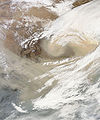 The first day of spring 2010 brought a massive sandstorm blowing from Inner Mongolia
 -
 On November 11, 2010, a wall of sand blew across northern China, covering much of the North China Plain and Shandong Peninsula.
 -
 Smog from Eastern China spread over neighboring areas in February 2004.
 -

-
 Natural color satellite image of a smog event in the heart of northern China
 -
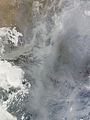 Dense smog settled over the North China Plain on February 20, 2011.
.png)


Environment
China is a party to the
See also
- History of human geography in China
- Environment of China
- List of islands of China
- List of rivers in China
- List of mountains in China
- Lakes in China
- North China Plain
- Geography of Hong Kong
- Geography of Macau
- Geographic information systems in China
- Zomia (geography)
Notes and references
- ^ a b c d e f g h i j k l "China". The World Factbook. CIA. Retrieved 31 December 2015.
- ^ Based on the 1999 and 2005 surveys of elevation of snow cap, not rock head. For more details, see Surveys.
- ^ "Yangtze River". University of Washington. Retrieved 31 December 2015.
- ^ CIA (October 1967), Communist China Map Folio, U.S. Central Intelligence Agency
- ISBN 9787503141782.
- ^ Hsu, Angel; Miao, William (29 April 2013). "28,000 Rivers Disappeared in China: What Happened?". The Atlantic. Retrieved 14 September 2018.
- ^ "The State of Religion in China". Council on Foreign Relations. Retrieved 13 October 2018.
- ^ "This fascinating map shows the new religious breakdown in China". Business Insider. Retrieved 13 October 2018.
- ^ a b "East Asia/Southeast Asia :: China — The World Factbook - Central Intelligence Agency". www.cia.gov. Retrieved 21 November 2018.
- S2CID 153871544.
- ^ "Arable land (hectares) | Data". data.worldbank.org. Retrieved 2 November 2018.
- ^ "Farming the World: China's Epic Race to Avoid a Food Crisis". Bloomberg. 22 May 2017. Retrieved 29 September 2022.
- ^ "East Asia/Southeast Asia :: China — The World Factbook - Central Intelligence Agency". www.cia.gov. Retrieved 17 November 2018.
- ^ ISBN 9780231176200.
- ^ "India and China 'to resolve dispute'". BBC News. 15 May 2015. Retrieved 26 November 2018.
- ^ "China sends ship to disputed sea". BBC News. 16 June 2011. Retrieved 26 November 2018.
- ^ "Tibet activist jailed after NYT video". BBC News. 22 May 2018. Retrieved 26 November 2018.
- ^ "Xinjiang profile". BBC News. 12 October 2018. Retrieved 26 November 2018.
- ^ "Tajikistan cedes land to China". BBC News. 2011. Retrieved 26 November 2018.
- Fitzpatrick, John. 1992. "The Middle Kingdom, the Middle Sea, and the Geographical Pivot of History". Review (fernand Braudel Center) 15 (3). Research Foundation of SUNY: 477–521. https://www.jstor.org/stable/40241233.
External links
- Chinese Academy of Sciences Institute of Geographical Sciences and Natural Resources
- Chinese Ecosystem Research Network (CERN)
- Illustrations of Famous Mountains from 1368 to 1644
| Sovereign states |
|
|---|---|
| States with limited recognition |
|
| Dependencies and other territories |
|