
Geography of Iceland
| Lowest point |
|
|---|---|
| Longest river |
|
| Largest lake | |
| Climate | Subpolar oceanic climate, Tundra |
| Terrain | Plateau interspersed with mountain peaks, volcanic peaks, icefields and a coast deeply indented by bays and fjords |
| Natural resources | Marine life, diatomite, hydrothermal power |
| Natural hazards | Volcanism, earthquakes, avalanches, and glacial lake outburst flooding |
| Environmental issues | Air pollution, climate change, desertification, hazardous wastes, marine dumping |
| Exclusive economic zone | 751,345 km2 (290,096 sq mi) |
Statistics

Iceland is an island country in Northern Europe, straddling the Eurasian and North American plates between the Greenland Sea and the North Atlantic Ocean, northwest of the British Isles.
Extent (locations outside mainland in parentheses)
- North: Rifstangi, 66°32′3" N (Kolbeinsey, 67°08,9 N)
- South: Kötlutangi, 63°23′6" N (Surtsey, 63°17,7 N)
- West: Bjargtangar, 24°32′1" W
- East: Gerpir, 13°29′6" W (Hvalbakur, 13°16,6 W)
Area:
- Total: 103,125 km2 (39,817 sq mi)
- Land: 100,329 km2
- Water: 2,796 km2
- Coastline
- Iceland has a coastline of 4,970 km.
Maritime claims:
- Territorial sea: 12 nmi (22.2 km; 13.8 mi)
- Exclusive economic zone: 751,345 km2 (290,096 sq mi) with 200 nmi (370.4 km; 230.2 mi)
- Continental shelf: 200 nmi (370.4 km; 230.2 mi) or to the edge of the continental margin
Elevation extremes:
- Lowest point: Atlantic Ocean 0 m
- Highest point: Hvannadalshnúkur2,110 m
Natural resources:
- diatomite, hydropower, geothermal power
Land use
- Arable land: 1.21%
- Permanent crops: 0%
- Other: 98.79% (2012)
- Total renewable water resources
- 170 km3 (2011)
- Freshwater withdrawal (domestic/industrial/agricultural)
- Total: 0.17 km3/yr (49%/8%/42%)
- Per capita: 539.2 m3/yr (2005)
- Natural hazards
- Volcanism, earthquakes, avalanches, and glacial lake outburst flooding (or jökulhlaups)
- Environment—current issues
- Water pollution from fertilizer runoff; inadequate wastewater treatment
Physical geography
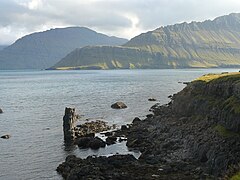
Iceland consists of eight geographical regions, Capital Region, Southern Peninsula, West, Westfjords, Northwest, Northeast, East and South.[1] Twenty per cent of the land is used for grazing, while only one per cent is cultivated. Iceland has lost most of the woodland that previously covered large areas of the country, but an ambitious reforestation program is currently underway.[2] Fossilized tree pollen and descriptions by the early settlers indicate that prior to human settlement, now thought to have occurred from around AD 800 onwards,[3][4] trees covered between thirty and forty per cent of the island. Today, however, there are only small patches of the original birch forests left, the most prominent being Hallormsstaðaskógur and Vaglaskógur. The country of Iceland contains 36 islands. The longest river on the island is Þjórsá at 230 kilometres (143 miles). Iceland has three national parks: Vatnajökull National Park, Snæfellsjökull National Park, and Þingvellir National Park.[5] The inhabited areas are on the coast, particularly in the southwest, while the central highlands are all but uninhabited. The island's terrain is mostly plateau interspersed with mountain peaks, icefields and a coast deeply indented by bays and fjords.
Highlands

The Highlands make up about half of Iceland's land area, which is of recent volcanic origin and consists of a mountainous lava desert (highest elevation 2,110 m (6,923 ft) above sea level) and other wastelands. The area is mostly uninhabited and uninhabitable.
Westfjords
The Westfjords region is composed of a large, mountainous peninsula on Iceland's northwestern coast. The coastline is marked by numerous fjords as its name suggests. The peninsula contains Iceland's northernmost glacier, Drangajökull.
Southern Peninsula
The
Capital Region
Home to Iceland's capital, Reykjavík, the Capital Region is the most densely populated area in Iceland. It is located on the southwest coast of the island near the Southern Peninsula. The majority of Reykjavík is located on the Seltjarnarnes peninsula. Mount Esja, at 914 metres (2,999 ft), is the highest mountain in the vicinity of Reykjavík. Several natural harbours exist and provide good fishing grounds.[6]
West
Located in the western portion of the island and north of the Capital Region. In Hvalfjörður fjord rests the second-tallest waterfall in Iceland, Glymur. West is also home to Borgarfjörður, a fjord with volcanic activity such as Deildartunguhver, a powerful hotspring. The 804-metre (2,638 ft) Hafnarfjall Mountain rises over the landscape.[7]
South
The southern portion of Iceland contains some of its most notable volcanoes such as Hekla, Eldgjá, and Katla. Alongside the volcanoes exist numerous glaciers such as Vatnajökull, Mýrdalsjökull, and Eyjafjallajökull. Basalt columns and black sand beaches are examples of the volcanic activity of the area. The area also contains mountain ranges and Iceland's highest peak, Hvannadalshnjúkur, as well as the Vestmannaeyjar (Westman Islands) archipelago.
East
East Iceland contains the majority of the island's vegetation and birch forests.
Glaciers

Around 10.2 per cent of the total land area is covered by
- Hofsjökull (827 km2)
- Langjökull (868 km2)
- Mýrdalsjökull (542 km2)
- Vatnajökull (7,764 km2)
Other notable glaciers include:
.jpg)
- Drangajökull (145 km2)
- Eiríksjökull (21 km2)
- Eyjafjallajökull (70 km2)
- Snæfellsjökull (10 km2).
- Tindfjallajökull (11 km2)
- Torfajökull (10 km2)
- Tungnafellsjökull (33 km2)
- Þórisjökull (25 km2)
- Þrándarjökull (16 km2)
Climate

Because of the moderating influence of the North Atlantic Current, the climate is temperate and characterized by damp, cool summers and relatively mild but windy winters. Reykjavík has an average temperature of 12 °C (53.6 °F) in July and 1 °C (34 °F) in January[9] It has a Köppen Climate Classification of Subpolar oceanic climate (Cfc) with most of the island classified as Tundra (ET).
Geology
Iceland has extensive
Geological activity

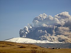
A geologically young land, Iceland is located on both the Iceland hotspot and the Mid-Atlantic Ridge, which runs right through it. This location means that the island is highly geologically active with earthquakes and volcanoes, notably Hekla, Eldgjá, Herðubreið and Eldfell. Eyjafjallajökull (1,666 m) erupted in 2010, disrupting European air traffic.[11] To demonstrate the geothermal activity, the Icelandic Meteorological Office said that during a single week in February 2021, around 17,000 earthquakes have hit the southwestern region of Reykjanes.[12]
Iceland has many
Environment—international agreements
Party to:
Signed, but not ratified:
- Marine Life Conservation
Images
-
 True colour satellite image of Iceland in winter
 -
 Three typical Icelandic landscapes
 -
 Iceland is rich in sulfur deposits.
 -
-
-
 Landscape as seen from Laugavegur hiking trail
 -


Maps
-
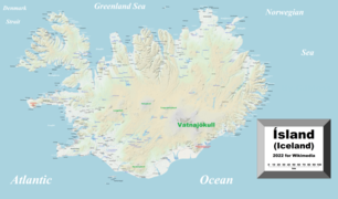
 Map of Iceland showing major towns and geographical features
 -
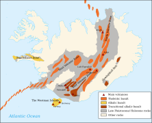 Active volcanic areas and systems in Iceland
 -
 Map showing the Mid-Atlantic Ridge splitting Iceland and separating the North American and Eurasian Plates
 -
 Topographic map of Iceland
 -
 Comprehensive map of Iceland


See also
- Extreme points of Europe
- Highlands of Iceland
- Iceland hotspot
- Iceland plume
- List of earthquakes in Iceland
- List of extreme points of Iceland
- List of fjords of Iceland
- List of islands of Iceland
- List of lakes of Iceland
- List of national parks of Iceland
- List of rivers of Iceland
- List of valleys of Iceland
- List of waterfalls of Iceland
References
- ^ "Iceland Regions - Iceland on the Web". www.icelandontheweb.com (in Icelandic). Retrieved 1 October 2018.
- ^ "Forestry in a treeless land". Iceland Forest Service. Archived from the original on 15 August 2016. Retrieved 12 October 2015.
- ^ "RAE 2008 : Submissions : RA1, RA2 and RA5c". www.rae.ac.uk. Archived from the original on 25 June 2018. Retrieved 12 November 2015.
- ^ "New View on the Origin of First Settlers in Iceland". Iceland Review Online. 4 June 2011. Archived from the original on 5 June 2011. Retrieved 12 October 2015.
- ^ "National parks in Iceland". Inspired By Iceland. Retrieved 20 September 2018.
- ^ "Iceland | Culture, History, & People". Encyclopedia Britannica. Retrieved 2 October 2018.
- ^ "the-classic-circle | Visit West Iceland". Visit West Iceland. Retrieved 2 October 2018.
- ^ "Heildarstærð jökla á Íslandi 2014 ("Total surface area of Icelandic glaciers 2014")" (PDF) (in Icelandic). Loftmyndir ehf. Archived from the original (PDF) on 17 March 2015. Retrieved 12 October 2015.
- ^ "Mánaðarmeðaltöl fyrir stöð 1 – Reykjavík ("Monthly data for station No 1 – Reykjavík")" (in Icelandic). Retrieved 12 October 2015.
- ^ "Plate boundaries, rifts and transforms in Iceland" (PDF). Jökull No. 58, 2008. Institute of Earth Sciences, University of Iceland. Retrieved 19 March 2014.
- ^ "The World Factbook – Central Intelligence Agency". www.cia.gov. Retrieved 17 September 2018.
- ^ Siad, Arnaud (3 March 2021). "17,000 earthquakes hit Iceland in the past week. An eruption could be imminent". CNN. Retrieved 4 March 2021.
- .
External links
- Iceland at the CIA World Factbook
 Media related to Geography of Iceland at Wikimedia Commons
![]() This article incorporates public domain material from The World Factbook.
This article incorporates public domain material from The World Factbook.